
| Memorials | : | 1 |
| Location | : | Genoa, Nance County, USA |
| Coordinate | : | 41.4471700, -97.7218400 |
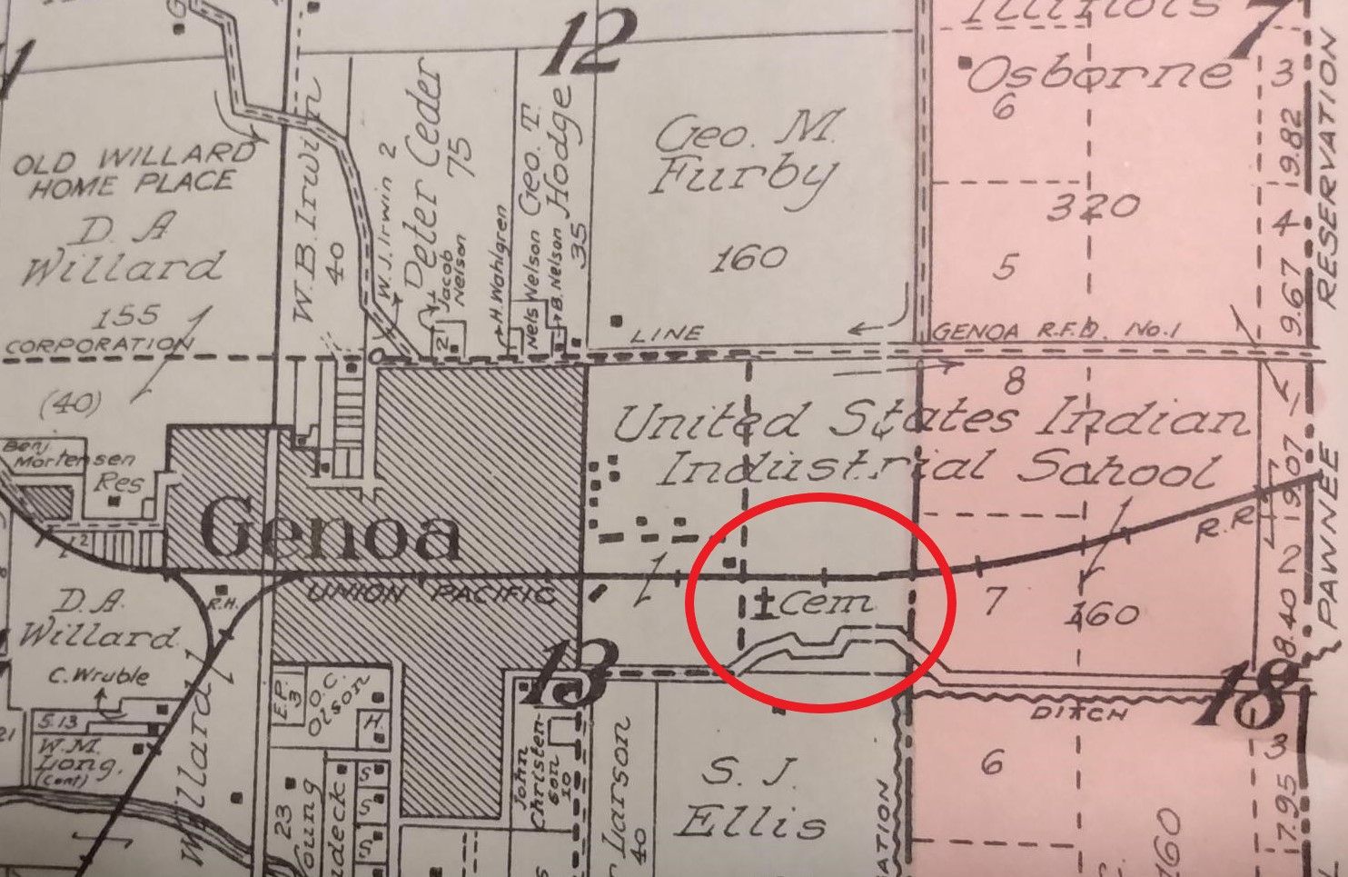
| Description | : | Established as a federal boarding school for Native American children, the Genoa Indian Industrial School operated from 1884 to 1934. The cemetery's exact location is unknown but old maps indicate it was located on the school grounds. |
frequently asked questions (FAQ):
-
Where is Genoa Indian Industrial School Cemetery?
Genoa Indian Industrial School Cemetery is located at Genoa, Nance County ,Nebraska ,USA.
-
Genoa Indian Industrial School Cemetery cemetery's updated grave count on graveviews.com?
1 memorials
-
Where are the coordinates of the Genoa Indian Industrial School Cemetery?
Latitude: 41.4471700
Longitude: -97.7218400
Nearby Cemetories:
1. Valley View Cemetery
Genoa, Nance County, USA
Coordinate: 41.4317017, -97.7319031
2. Friends Cemetery
Oconee, Platte County, USA
Coordinate: 41.4775009, -97.6941986
3. Saints Peter and Paul Cemetery
Krakow, Nance County, USA
Coordinate: 41.3908157, -97.7522888
4. Gruetli Cemetery
Monroe, Platte County, USA
Coordinate: 41.4290000, -97.5810000
5. New Hope Cemetery
Monroe, Platte County, USA
Coordinate: 41.5413000, -97.6520000
6. Lingle Cemetery
Genoa, Nance County, USA
Coordinate: 41.5108000, -97.8384000
7. West Hill Cemetery
Platte County, USA
Coordinate: 41.5558014, -97.7161026
8. Sunnyside Cemetery
Nance County, USA
Coordinate: 41.4016991, -97.8692017
9. Saint Paul Evangelical Lutheran Cemetery
Monroe, Platte County, USA
Coordinate: 41.5651140, -97.6740360
10. Silver Creek Cemetery
Silver Creek, Merrick County, USA
Coordinate: 41.3222008, -97.6830978
11. Skeedee Cemetery
Nance County, USA
Coordinate: 41.5038986, -97.8850021
12. Evergreen Cemetery
Saint Edward, Boone County, USA
Coordinate: 41.5677986, -97.8411026
13. Saint Edward Catholic Cemetery
Saint Edward, Boone County, USA
Coordinate: 41.5684800, -97.8424800
14. Palestine Cemetery
Rosenborg, Platte County, USA
Coordinate: 41.5980000, -97.7057000
15. Saint Lawrence Cemetery
Silver Creek, Merrick County, USA
Coordinate: 41.2942009, -97.7052994
16. Zion Lutheran Grand Prairie Cemetery
Platte Center, Platte County, USA
Coordinate: 41.5546989, -97.5702972
17. German Lutheran Martens Cemetery
Platte Center, Platte County, USA
Coordinate: 41.5550200, -97.5707000
18. Greenwood Cemetery
Platte Center, Platte County, USA
Coordinate: 41.5708008, -97.5802994
19. Postville Cemetery
Platte County, USA
Coordinate: 41.5924644, -97.6203079
20. Fairview Cemetery
Silver Creek, Merrick County, USA
Coordinate: 41.2920000, -97.8006000
21. Saint Johns Lutheran Church Cemetery
Polk County, USA
Coordinate: 41.3427940, -97.5421140
22. Bethany Lutheran Cemetery
Platte County, USA
Coordinate: 41.6232700, -97.7177200
23. Saint Stanislaus Catholic Cemetery
Duncan, Platte County, USA
Coordinate: 41.3926000, -97.4962000
24. Burrows Cemetery
Platte County, USA
Coordinate: 41.5983009, -97.5813980