
| Memorials | : | 0 |
| Location | : | Clay County, USA |
| Coordinate | : | 29.9410900, -81.9472530 |
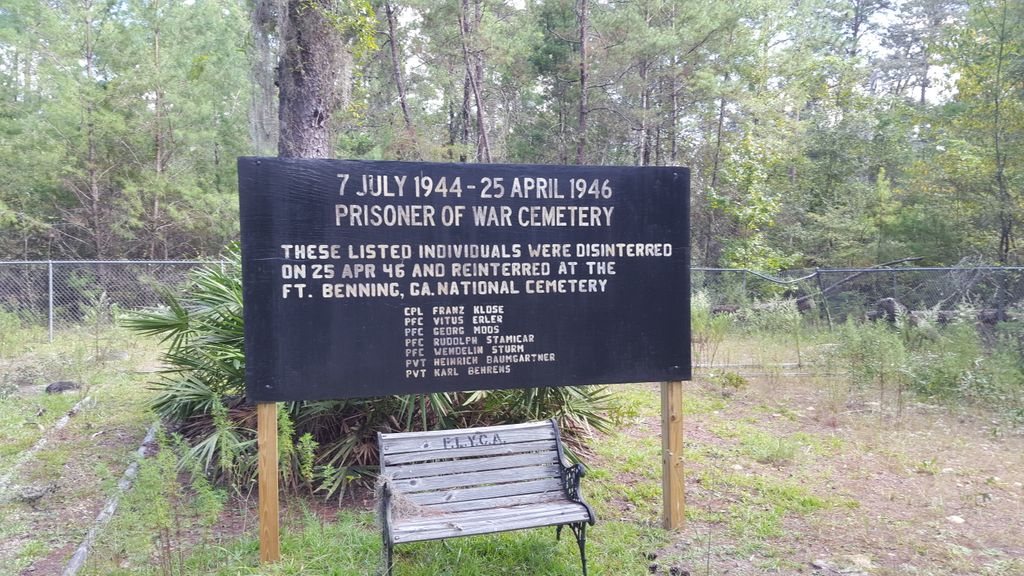
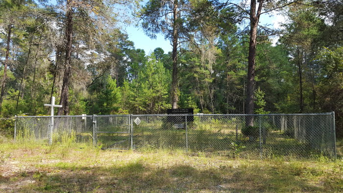
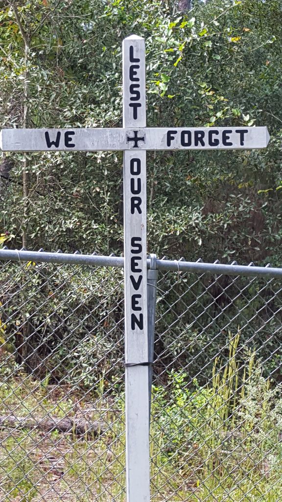
| Description | : | Located on Camp Blanding Joint Training Center, Clay County during WWII, it was the cemetery in which German POWs were interred during the war. All of the prisoners were disinterred on 25 April 196 and reinterred at the Ft. Benning, GA National Cemetery. All grave markers still remain. |
frequently asked questions (FAQ):
-
Where is German POW Camp Cemetery?
German POW Camp Cemetery is located at Clay County ,Florida ,USA.
-
German POW Camp Cemetery cemetery's updated grave count on graveviews.com?
0 memorials
-
Where are the coordinates of the German POW Camp Cemetery?
Latitude: 29.9410900
Longitude: -81.9472530

Nearby Cemetories:
1. Beulah Cemetery
Kingsley, Clay County, USA
Coordinate: 29.9421997, -81.9186020
2. Old Conway Cemetery
Middleburg, Clay County, USA
Coordinate: 29.9827995, -81.9499969
3. John James Conway Cemetery
Kingsley, Clay County, USA
Coordinate: 29.9847083, -81.9499893
4. Beulah Missionary Baptist Church Cemetery
Green Cove Springs, Clay County, USA
Coordinate: 29.9427376, -81.8963776
5. Evergreen Cemetery
Belmore, Clay County, USA
Coordinate: 29.8994045, -81.8950958
6. Kingsley Lake Cemetery
Clay County, USA
Coordinate: 29.9686070, -82.0158140
7. Oak Grove Cemetery
Clay County, USA
Coordinate: 30.0121994, -81.9555969
8. Oak Grove Baptist Church Cemetery
Middleburg, Clay County, USA
Coordinate: 30.0117702, -81.9307556
9. Fowler Cemetery
Middleburg, Clay County, USA
Coordinate: 30.0286007, -81.9005966
10. Black Creek Baptist Church Cemetery
Penney Farms, Clay County, USA
Coordinate: 29.9823590, -81.8441100
11. Lee Cemetery
Clay County, USA
Coordinate: 29.8568993, -82.0175018
12. Blue Pond Cemetery
Clay County, USA
Coordinate: 29.8558006, -82.0327988
13. Griffis Family Cemetery
Starke, Bradford County, USA
Coordinate: 29.9107826, -82.0797910
14. Budington Cemetery
Middleburg, Clay County, USA
Coordinate: 30.0521202, -81.8781815
15. Salem Cemetery
Clay County, USA
Coordinate: 29.9071999, -81.8056030
16. Gadara Cemetery
Keystone Heights, Clay County, USA
Coordinate: 29.8085995, -81.9175034
17. Saint Marks Episcopal Church Cemetery
Starke, Bradford County, USA
Coordinate: 29.9445190, -82.1065280
18. Peetsville Cemetery
Lawtey, Bradford County, USA
Coordinate: 30.0257030, -82.0816250
19. Middleburg Methodist Church Cemetery
Middleburg, Clay County, USA
Coordinate: 30.0676480, -81.8619340
20. Hope Baptist Cemetery
Starke, Bradford County, USA
Coordinate: 29.8381004, -82.0682983
21. Penney Memorial Cemetery
Penney Farms, Clay County, USA
Coordinate: 29.9838430, -81.7847050
22. Fort Heileman Cemetery
Middleburg, Clay County, USA
Coordinate: 30.0732666, -81.8546002
23. Branning Cemetery
Middleburg, Clay County, USA
Coordinate: 30.0773521, -81.8479440
24. Odd Fellows Cemetery
Starke, Bradford County, USA
Coordinate: 29.9006700, -82.1273090