
| Memorials | : | 0 |
| Location | : | Gainesville, Hall County, USA |
| Coordinate | : | 34.3860560, -83.9668800 |
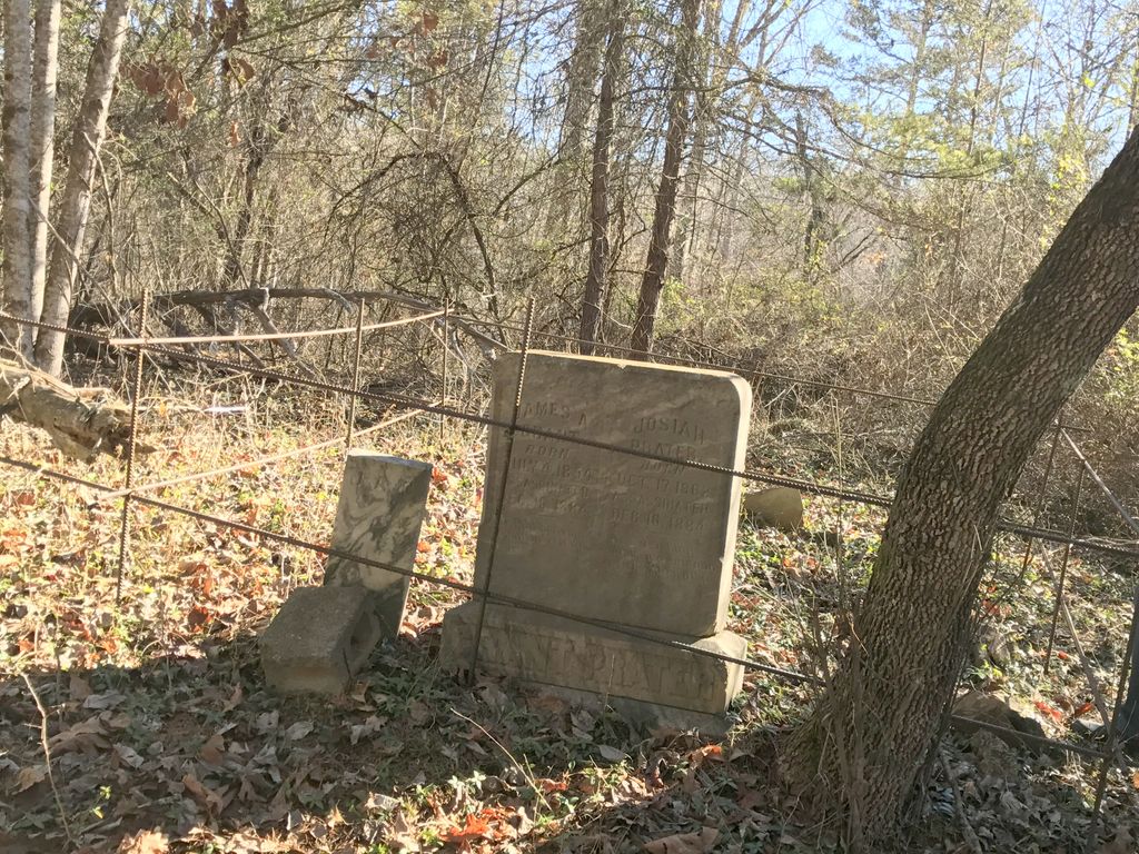
| Description | : | Grant - Prater Cemetery: Abstracted By: Sybil McRay on April 22, 1968 Grant Ford Road, off Cool Springs Road, across the road from WOW Camp (description written in 1968) Additional Comments: Tradition says these two men had a still on the property. Government men came and a gunfight between several men insued. It was on and off several hours. The two men killed were buried where they died. One headstone has both names. The locals felt the men were assassinated. In fact, 'assassinated' is inscribed after each name on the marker. The government men were not charged. |
frequently asked questions (FAQ):
-
Where is Grant - Prater Cemetery?
Grant - Prater Cemetery is located at 6033 Grant Ford Rd Gainesville, Hall County ,Georgia , 30506USA.
-
Grant - Prater Cemetery cemetery's updated grave count on graveviews.com?
0 memorials
-
Where are the coordinates of the Grant - Prater Cemetery?
Latitude: 34.3860560
Longitude: -83.9668800
Nearby Cemetories:
1. Rev. Humphrey Grant Cemetery
Gainesville, Hall County, USA
Coordinate: 34.3806150, -83.9709140
2. Grant Family Cemetery
Hall County, USA
Coordinate: 34.3665420, -83.9751720
3. Cool Springs Baptist Church Cemetery
Gainesville, Hall County, USA
Coordinate: 34.3819008, -83.9375000
4. Prospect Baptist Church Cemetery
Gainesville, Hall County, USA
Coordinate: 34.3602982, -83.9606018
5. Pleasant Hill Full Gospel Church Cemetery
Dawsonville, Dawson County, USA
Coordinate: 34.4014851, -84.0007420
6. Moss Memorial Gardens
Dawsonville, Dawson County, USA
Coordinate: 34.3926140, -84.0109670
7. Harmony Baptist Church Cemetery
Dawsonville, Dawson County, USA
Coordinate: 34.3935700, -84.0113900
8. Chestatee Baptist Church Cemetery
Gainesville, Hall County, USA
Coordinate: 34.3405991, -83.9518967
9. Palmour Cemetery
Dawson County, USA
Coordinate: 34.4194440, -84.0116670
10. Liberty Baptist Church Cemetery
Dawsonville, Dawson County, USA
Coordinate: 34.3491180, -84.0109390
11. Etowah Baptist Church Cemetery
Dahlonega, Lumpkin County, USA
Coordinate: 34.4299620, -84.0027930
12. Living Waters Outreach Church Cemetery
Murrayville, Hall County, USA
Coordinate: 34.4126010, -83.9105970
13. Peter Elrod Family Cemetery
Gainesville, Hall County, USA
Coordinate: 34.3946230, -83.9006500
14. Yellow Creek Baptist Church Cemetery
Murrayville, Hall County, USA
Coordinate: 34.4314003, -83.9281006
15. Adams Garden Family Cemetery
Dahlonega, Lumpkin County, USA
Coordinate: 34.4425400, -83.9689900
16. Rock Hill Cemetery
Gainesville, Hall County, USA
Coordinate: 34.3772011, -83.8989029
17. Word of Life Pentecostal Deliverance Center
Dahlonega, Lumpkin County, USA
Coordinate: 34.4412370, -83.9848640
18. Elrod Family Cemetery
Gainesville, Hall County, USA
Coordinate: 34.4006210, -83.8992210
19. Hendrix Family Cemetery
Dawsonville, Dawson County, USA
Coordinate: 34.3531500, -84.0249000
20. Murrayville Congregational Holiness Church Cemeter
Murrayville, Hall County, USA
Coordinate: 34.4243640, -83.9098790
21. Murrayville Baptist Church Cemetery
Murrayville, Hall County, USA
Coordinate: 34.4159140, -83.8990630
22. Bethel United Methodist Church Cemetery
Dawsonville, Dawson County, USA
Coordinate: 34.3658820, -84.0431540
23. Bethel Tabernacle Cemetery
Gainesville, Hall County, USA
Coordinate: 34.3564040, -83.8948420
24. Hopewell United Methodist Church Cemetery
Gainesville, Hall County, USA
Coordinate: 34.4029700, -83.8882400