
| Memorials | : | 0 |
| Location | : | Homedale, Owyhee County, USA |
| Coordinate | : | 43.5744990, -117.0176340 |
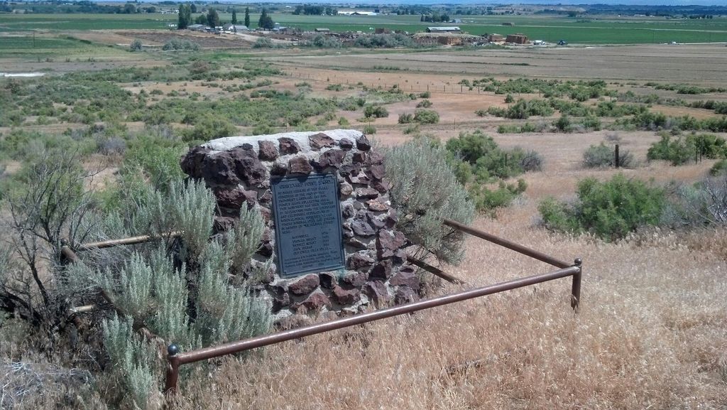
| Description | : | The "cemetery" is located 4 miles west of Homedale off highway 201, on the Oregon, Idaho border in a rich mineral laden area of the Owyhee's called Graveyard Point. Originally called Round Hill Cemtery, the old burial ground is located at the end of Graveyard Point Road, with a short hike up the hill. The location was originally chosen in a high place, safe from washouts and floods. Unfortunately, a canal was built behind it some years later, and after an unfortunate breakage, the cemetery was completely flooded, destroying markings of graves. A standing monument was built in the early... Read More |
frequently asked questions (FAQ):
-
Where is Graveyard Point Cemetery?
Graveyard Point Cemetery is located at Graveyard Point Road Homedale, Owyhee County ,Idaho , 83628USA.
-
Graveyard Point Cemetery cemetery's updated grave count on graveviews.com?
0 memorials
-
Where are the coordinates of the Graveyard Point Cemetery?
Latitude: 43.5744990
Longitude: -117.0176340
Nearby Cemetories:
1. Nielsen Farm Cemetery
Homedale, Owyhee County, USA
Coordinate: 43.5600120, -117.0042790
2. Marsing-Homedale Cemetery
Marsing, Owyhee County, USA
Coordinate: 43.5457993, -116.8910980
3. Fargo Cemetery
Wilder, Canyon County, USA
Coordinate: 43.6500015, -116.9313965
4. Wilder Cemetery
Wilder, Canyon County, USA
Coordinate: 43.6683006, -116.9222031
5. Roswell Cemetery
Roswell, Canyon County, USA
Coordinate: 43.7435989, -116.9702988
6. Greenleaf Cemetery
Greenleaf, Canyon County, USA
Coordinate: 43.6693720, -116.8151310
7. Pleasant Ridge Cemetery
Caldwell, Canyon County, USA
Coordinate: 43.6549988, -116.7833023
8. Peaceful Valley Cemetery
Knowlton Heights, Canyon County, USA
Coordinate: 43.5382996, -116.7584991
9. Owyhee Pioneer Cemetery
Owyhee, Malheur County, USA
Coordinate: 43.7762500, -117.0787700
10. Lower Boise Cemetery
Parma, Canyon County, USA
Coordinate: 43.7599983, -116.8833008
11. Owyhee River Cemetery
Owyhee, Malheur County, USA
Coordinate: 43.7956800, -117.0516300
12. Parma Cemetery
Parma, Canyon County, USA
Coordinate: 43.7919006, -116.9511032
13. Owyhee Cemetery
Nyssa, Malheur County, USA
Coordinate: 43.7957993, -117.0847015
14. Saint Davids Episcopal Church Memorial Garden
Caldwell, Canyon County, USA
Coordinate: 43.6538960, -116.6958430
15. McBride Road Cemetery
Rockville, Malheur County, USA
Coordinate: 43.3283005, -117.0625916
16. Rockville Cemetery
Malheur County, USA
Coordinate: 43.3272018, -117.0658035
17. Hillcrest Memorial Gardens
Caldwell, Canyon County, USA
Coordinate: 43.6042540, -116.6694670
18. Manley Family Cemetery
Givens Hot Springs, Owyhee County, USA
Coordinate: 43.4151490, -116.7188100
19. Canyon Hill Cemetery
Caldwell, Canyon County, USA
Coordinate: 43.6893997, -116.6753006
20. Givens Springs Pioneer Cemetery
Givens Hot Springs, Owyhee County, USA
Coordinate: 43.4086100, -116.7024400
21. Antioch Cemetery
Nampa, Canyon County, USA
Coordinate: 43.5895500, -116.5961100
22. Hilltop Memorial Cemetery
Nyssa, Malheur County, USA
Coordinate: 43.8834010, -117.0481340
23. Middleton Cemetery
Middleton, Canyon County, USA
Coordinate: 43.7168080, -116.6325860
24. Ward Family Massacre Memorial Burial Site
Middleton, Canyon County, USA
Coordinate: 43.6768960, -116.6086260