
| Memorials | : | 1 |
| Location | : | Monroe, Green County, USA |
| Coordinate | : | 42.6243640, -89.6555190 |
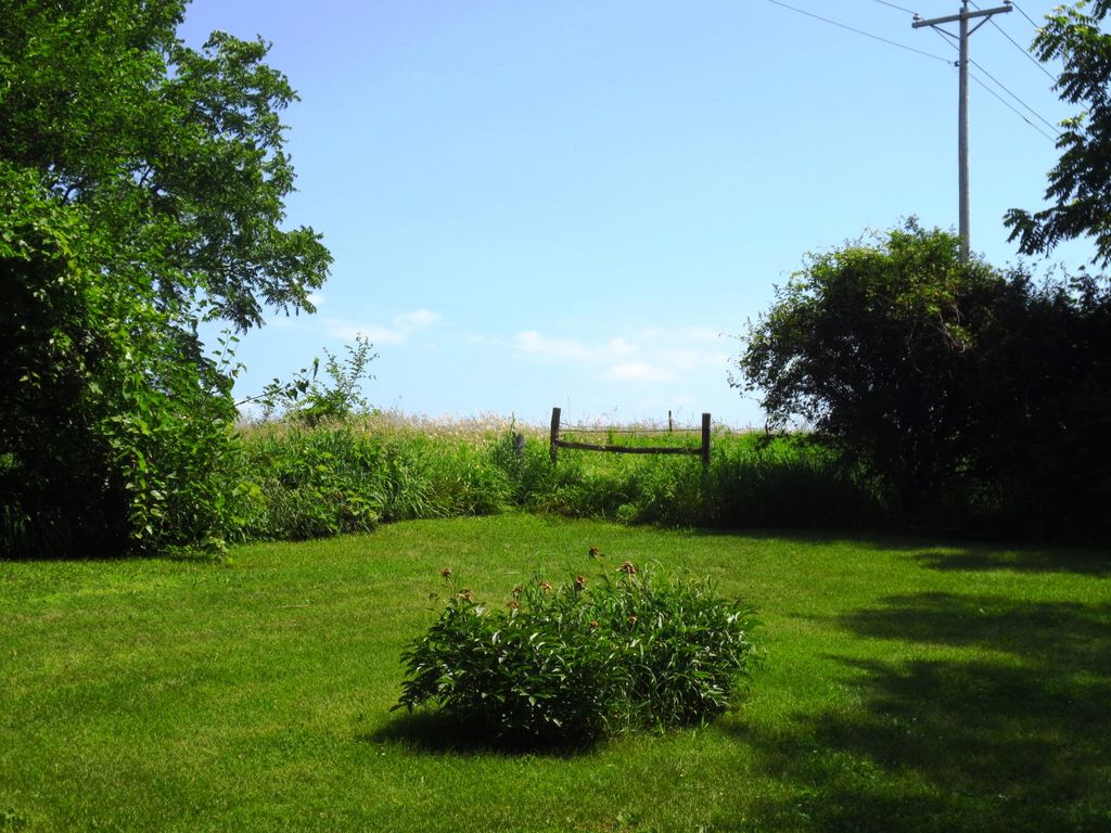
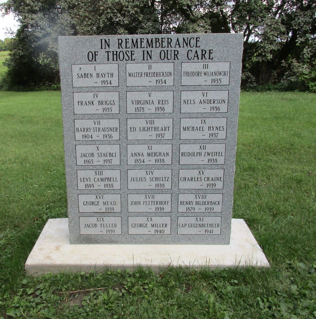
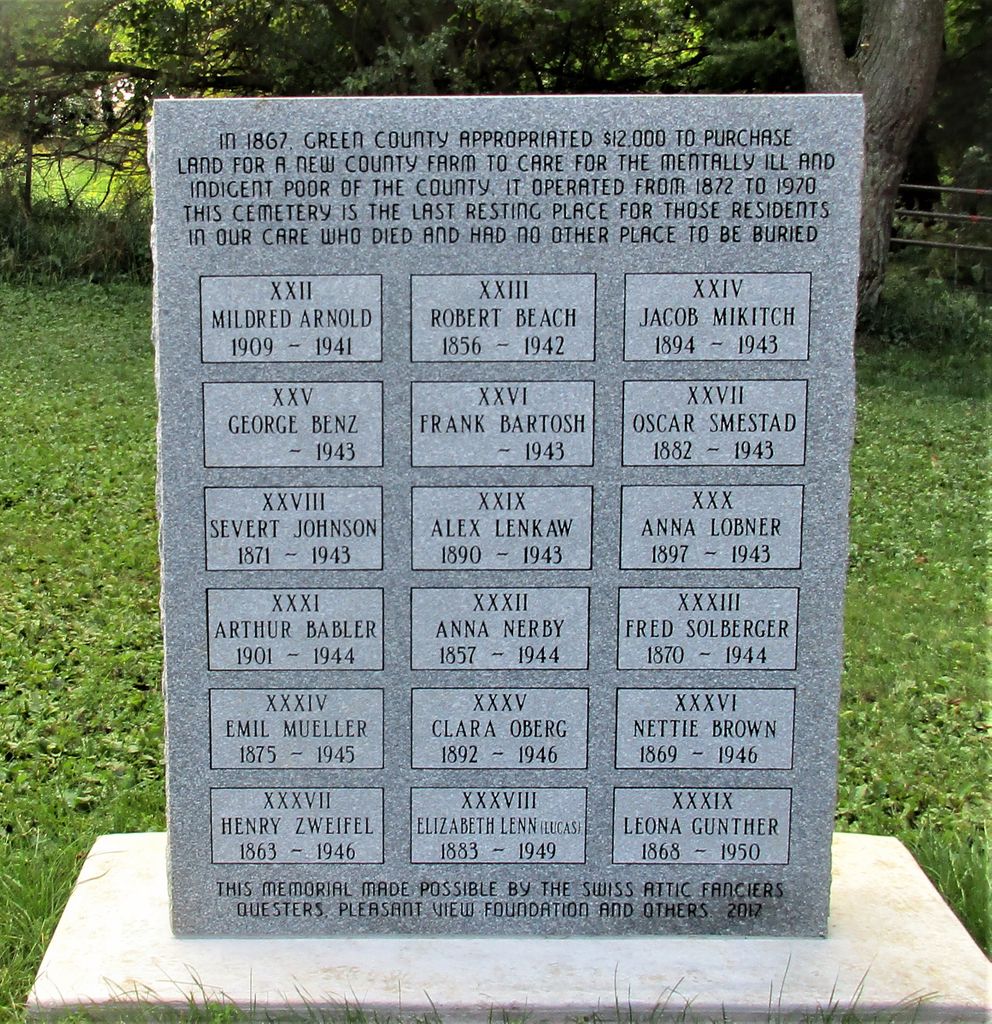
| Description | : | The County Farm Cemetery is at the intersection of Highway 81 and County trunk N. Most graves were never marked and those that were have had the markers removed. There is a single marker to mark the cemetery. The cemetery serves as a small county park now. |
frequently asked questions (FAQ):
-
Where is Green County Farm Cemetery?
Green County Farm Cemetery is located at Monroe, Green County ,Wisconsin ,USA.
-
Green County Farm Cemetery cemetery's updated grave count on graveviews.com?
1 memorials
-
Where are the coordinates of the Green County Farm Cemetery?
Latitude: 42.6243640
Longitude: -89.6555190
Nearby Cemetories:
1. Iliff Cemetery
Monroe, Green County, USA
Coordinate: 42.6397018, -89.6853027
2. Old Calvary Cemetery
Monroe, Green County, USA
Coordinate: 42.6021996, -89.6810989
3. Calvary Cemetery
Monroe, Green County, USA
Coordinate: 42.5942001, -89.6232986
4. Greenwood Cemetery
Monroe, Green County, USA
Coordinate: 42.5922012, -89.6247025
5. Benkert Bushnell Cemetery
Stearns, Green County, USA
Coordinate: 42.6699982, -89.6611023
6. Bethel Hawthorne Cemetery
Clarno, Green County, USA
Coordinate: 42.5718994, -89.6750031
7. Cold Springs Farm
Monroe, Green County, USA
Coordinate: 42.6758070, -89.6216400
8. Richland Cemetery
Jefferson, Green County, USA
Coordinate: 42.5907300, -89.5826300
9. Franklin Cemetery
Browntown, Green County, USA
Coordinate: 42.5875015, -89.7303009
10. Dutch Hollow Cemetery
Sylvester, Green County, USA
Coordinate: 42.6730995, -89.5792007
11. Michael Cemetery
Browntown, Green County, USA
Coordinate: 42.5821991, -89.7611008
12. Figi Farm Cemetery
Clarno, Green County, USA
Coordinate: 42.5420900, -89.7056700
13. Union-Benkert Cemetery
Monticello, Green County, USA
Coordinate: 42.7159070, -89.6547190
14. Washington Reformation Church Cemetery
Monticello, Green County, USA
Coordinate: 42.7237080, -89.6809460
15. Lewis Cemetery
Jordan, Green County, USA
Coordinate: 42.6563988, -89.7882996
16. Old Pioneer Cemetery
Clarno, Green County, USA
Coordinate: 42.5267500, -89.7003400
17. West Clarno Pioneer Cemetery
Clarno, Green County, USA
Coordinate: 42.5190000, -89.6535400
18. East Clarno Cemetery
Clarno, Green County, USA
Coordinate: 42.5190500, -89.6208400
19. Truax Burial Grounds
Monticello, Green County, USA
Coordinate: 42.6976600, -89.5454700
20. Saucerman Cemetery
Browntown, Green County, USA
Coordinate: 42.5485992, -89.7639008
21. Jordan Lutheran Church Cemetery
Browntown, Green County, USA
Coordinate: 42.6108100, -89.8039700
22. Staver Church Cemetery
Clarno, Green County, USA
Coordinate: 42.5201100, -89.7192800
23. Mount Vernon Cemetery
Juda, Green County, USA
Coordinate: 42.5955570, -89.5038150
24. Shooks Prairie Cemetery
Adams, Green County, USA
Coordinate: 42.7202988, -89.7427979