| Memorials | : | 0 |
| Location | : | Hopkinsville, Christian County, USA |
| Coordinate | : | 37.0767890, -87.2980940 |
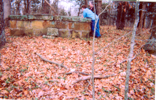
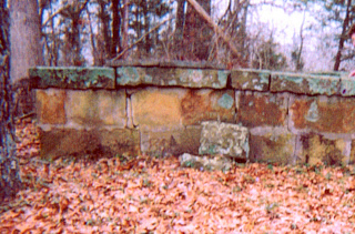
| Description | : | Directions from Christian County Cemetery book: "From Hopkinsville at intersection of 107 N. and East 7th Street go on 107 N. 14.5 miles turn left at Red Bridge Road go 5.2 miles where road forks-go right. Cemetery .3 miles on right in brick wall in the woods." (The cemetery is off the Cary's Bridge Road) John W. Grissom provided in his will "6thly, now my further wish that so much of my perishable property be sold as my wife may be advised, will be sufficient to inclose a pieces of ground that I... Read More |
frequently asked questions (FAQ):
-
Where is Grissom Cemetery?
Grissom Cemetery is located at Hopkinsville, Christian County ,Kentucky ,USA.
-
Grissom Cemetery cemetery's updated grave count on graveviews.com?
0 memorials
-
Where are the coordinates of the Grissom Cemetery?
Latitude: 37.0767890
Longitude: -87.2980940
Nearby Cemetories:
1. Ebling Cemetery
Christian County, USA
Coordinate: 37.0672780, -87.2948600
2. Grace Cemetery #1
Christian County, USA
Coordinate: 37.0668450, -87.2848290
3. Bass Cemetery #2
Christian County, USA
Coordinate: 37.0957985, -87.3000031
4. Overton Cemetery
Haleys Mill, Christian County, USA
Coordinate: 37.0806710, -87.3258380
5. Cary Cemetery
Muhlenberg County, USA
Coordinate: 37.0938988, -87.2761002
6. Jackson Cemetery #1
Apex, Christian County, USA
Coordinate: 37.0821600, -87.3296360
7. Jackson Cemetery #3
Apex, Christian County, USA
Coordinate: 37.0876730, -87.3365560
8. Atkinson Cemetery
Hopkinsville, Christian County, USA
Coordinate: 37.1002998, -87.3383026
9. Rock Bridge Cemetery
Apex, Christian County, USA
Coordinate: 37.0980000, -87.3410670
10. Haleys Mill Cemetery
Haleys Mill, Christian County, USA
Coordinate: 37.0767560, -87.3500630
11. Coal Creek Cemetery
Crofton, Christian County, USA
Coordinate: 37.0618070, -87.3477860
12. Pennington Cemetery
Apex, Christian County, USA
Coordinate: 37.0883400, -87.3520090
13. Lile Family Cemetery
Greenville, Muhlenberg County, USA
Coordinate: 37.1241910, -87.3021700
14. Dunning Cemetery
Christian County, USA
Coordinate: 37.0802994, -87.3610992
15. Lone Star Baptist Church Cemetery
Greenville, Muhlenberg County, USA
Coordinate: 37.0852200, -87.2344720
16. Atkinson Cemetery
Bancroft, Muhlenberg County, USA
Coordinate: 37.1302130, -87.2985650
17. Hale Cemetery
Bluff Spring, Christian County, USA
Coordinate: 37.0172005, -87.3069000
18. McKinney Family Cemetery
Bluff Spring, Christian County, USA
Coordinate: 37.0170000, -87.3103330
19. Jackson Cemetery #2
Apex, Christian County, USA
Coordinate: 37.1264500, -87.3427680
20. Judges Chapel Baptist Church Cemetery
Fruit Hill, Christian County, USA
Coordinate: 37.0343000, -87.3562230
21. Faulk Cemetery
Mortons Gap, Hopkins County, USA
Coordinate: 37.1400000, -87.2800000
22. Cave Springs Baptist Church Cemetery
Greenville, Muhlenberg County, USA
Coordinate: 37.1330440, -87.2525310
23. Pace-Knight Cemetery
Greenville, Muhlenberg County, USA
Coordinate: 37.1417470, -87.2650560
24. Rice Cemetery
Greenville, Muhlenberg County, USA
Coordinate: 37.1391983, -87.2566986


