
| Memorials | : | 0 |
| Location | : | Worthville, Carroll County, USA |
| Coordinate | : | 38.5970000, -85.0728000 |
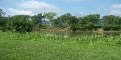
| Description | : | This cemetery which sits near the mouth of Eagle Creek originally was in Gallatin County and after County lines were redrawn in the early 1800’s, it is now in Carroll County. The last known graves there were the early 1900’s. Information from family deeds and Census reports both confirmed. It is specifically unknown where the cemetery owned by Jeremiah Gullion once was on the banks of the Creek due to longstanding flooding issues and county lines changing. No markers have been discovered after many attempts throughout the years. The cemetery photo captures the best known location from deed... Read More |
frequently asked questions (FAQ):
-
Where is Gullion Cemetery?
Gullion Cemetery is located at Happy Hollow Lane Worthville, Carroll County ,Kentucky , 41098USA.
-
Gullion Cemetery cemetery's updated grave count on graveviews.com?
0 memorials
-
Where are the coordinates of the Gullion Cemetery?
Latitude: 38.5970000
Longitude: -85.0728000
Nearby Cemetories:
1. Worthville Masonic Cemetery
Worthville, Carroll County, USA
Coordinate: 38.6063240, -85.0721170
2. Batts Cemetery #2
Henry County, USA
Coordinate: 38.5794449, -85.1213913
3. Moore Cemetery
Carroll County, USA
Coordinate: 38.6016972, -85.1326222
4. Coleman Cemetery
Carroll County, USA
Coordinate: 38.6114400, -85.1394800
5. DeMint Cemetery
Carroll County, USA
Coordinate: 38.6377810, -85.1266660
6. Stafford Cemetery
Carroll County, USA
Coordinate: 38.6422005, -85.0224991
7. Edrington Cemetery
Henry County, USA
Coordinate: 38.5777779, -85.1458359
8. English Cemetery
English, Carroll County, USA
Coordinate: 38.6293200, -85.1390600
9. Carraco Cemetery
Carroll County, USA
Coordinate: 38.6527730, -85.1275140
10. Berryman Cemetery
Owen County, USA
Coordinate: 38.5527954, -85.0011749
11. Old Schoolhouse Cemetery
Sanders, Carroll County, USA
Coordinate: 38.6373570, -84.9968950
12. Martinie Cemetery
Lacie, Henry County, USA
Coordinate: 38.5286110, -85.1091630
13. Whites Run Baptist Church Cemetery
Easterday, Carroll County, USA
Coordinate: 38.6754200, -85.0745100
14. Hanks Cemetery
Ghent, Carroll County, USA
Coordinate: 38.6682450, -85.0295630
15. Arnold Cemetery
Owen County, USA
Coordinate: 38.5985985, -84.9661026
16. Drennon Chapel Cemetery
Drennon Springs, Henry County, USA
Coordinate: 38.5158348, -85.0449982
17. Carroll County Poor Farm Cemetery
Carroll County, USA
Coordinate: 38.6688880, -85.1308010
18. Humston Cemetery
Henry County, USA
Coordinate: 38.5141678, -85.1152802
19. Tandy Cemetery
Carroll County, USA
Coordinate: 38.6855600, -85.0483500
20. Joseph Ellis McCann Cemetery
Carroll County, USA
Coordinate: 38.6927670, -85.0823280
21. Cove Hill Cemetery
Carroll County, USA
Coordinate: 38.6257600, -85.1908200
22. Gap Hill Cemetery
Carrollton, Carroll County, USA
Coordinate: 38.6749992, -85.1464005
23. Elmore Cemetery
Owen County, USA
Coordinate: 38.6128006, -84.9436035
24. Foree Cemetery #5
Henry County, USA
Coordinate: 38.5558319, -85.1933365