
| Memorials | : | 0 |
| Location | : | Apalachicola, Franklin County, USA |
| Coordinate | : | 29.6370054, -85.1031001 |
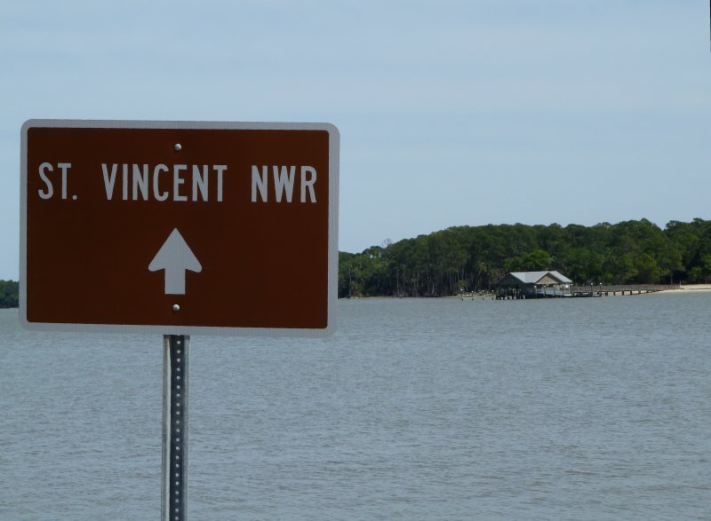
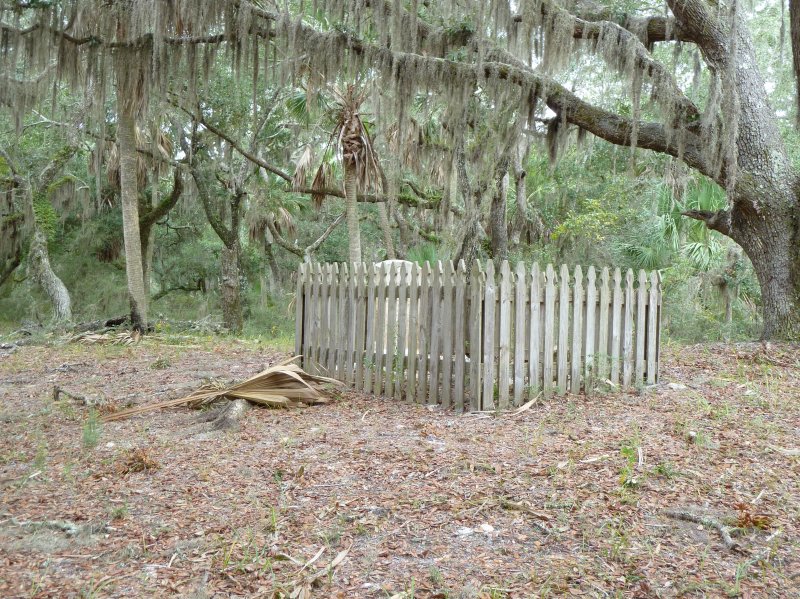
| Description | : | St. Vincent Island is a National Wildlife Refuge. The only marked grave there is for George Hatch, a former owner of the island. Access is by boat from the Indian Pass Boat Ramp off County Road 30B, which is 22 miles west of Apalachicola. |
frequently asked questions (FAQ):
-
Where is Hatch Cemetery?
Hatch Cemetery is located at Saint Vincent Island Apalachicola, Franklin County ,Florida , 32320USA.
-
Hatch Cemetery cemetery's updated grave count on graveviews.com?
0 memorials
-
Where are the coordinates of the Hatch Cemetery?
Latitude: 29.6370054
Longitude: -85.1031001
Nearby Cemetories:
1. Box R Cemetery
Apalachicola, Franklin County, USA
Coordinate: 29.7563290, -85.0911054
2. Stone Hill Cemetery
Apalachicola, Franklin County, USA
Coordinate: 29.7307370, -85.0139756
3. Magnolia Cemetery
Apalachicola, Franklin County, USA
Coordinate: 29.7321910, -85.0023390
4. Chestnut Cemetery
Apalachicola, Franklin County, USA
Coordinate: 29.7253050, -84.9879030
5. Trinity Episcopal Church Memorial Garden
Apalachicola, Franklin County, USA
Coordinate: 29.7257500, -84.9860930
6. John Gorrie Memorial
Apalachicola, Franklin County, USA
Coordinate: 29.7251301, -84.9854431
7. Forest Hill Cemetery
Port Saint Joe, Gulf County, USA
Coordinate: 29.7800007, -85.2727966
8. Holly Hill Cemetery
Port Saint Joe, Gulf County, USA
Coordinate: 29.7916530, -85.2742580
9. Saint Josephs Cemetery
Port Saint Joe, Gulf County, USA
Coordinate: 29.7929900, -85.2876000
10. Old Saint Joseph Cemetery
Port Saint Joe, Gulf County, USA
Coordinate: 29.7940600, -85.2878300
11. Eastpoint Cemetery
Eastpoint, Franklin County, USA
Coordinate: 29.7453003, -84.8688965
12. Porters Bar Cemetery
Franklin County, USA
Coordinate: 29.7525005, -84.8488998
13. Bloody Bluff Cemetery
Apalachicola, Franklin County, USA
Coordinate: 29.8736424, -85.0100503
14. Renegade Cemetery
Fort Gadsden, Franklin County, USA
Coordinate: 29.9372349, -85.0104904
15. Brown and Smith Cemetery
Eastpoint, Franklin County, USA
Coordinate: 29.9480991, -85.0028000
16. Wright Cemetery
Eastpoint, Franklin County, USA
Coordinate: 30.0011787, -85.0031324
17. Hathcock Cemetery
Sumatra, Liberty County, USA
Coordinate: 30.0169200, -85.0260100
18. Robinson Cemetery
Wewahitchka, Gulf County, USA
Coordinate: 30.0200005, -85.1656036
19. Sumatra Cemetery
Fort Gadsden, Franklin County, USA
Coordinate: 30.0129270, -84.9822820
20. Vonier Cemetery
Franklin County, USA
Coordinate: 30.0118970, -84.9723880
21. Sumatra Tower Cemetery
Sumatra, Liberty County, USA
Coordinate: 30.0277448, -84.9890139
22. Roberts Cemetery
Wewahitchka, Gulf County, USA
Coordinate: 30.0569000, -85.1810989
23. Pleasant Rest Cemetery
Wewahitchka, Gulf County, USA
Coordinate: 30.0063300, -85.3505400
24. Church of the Ascension Columbarium
Carrabelle Beach, Franklin County, USA
Coordinate: 29.8527020, -84.6634740