
| Memorials | : | 0 |
| Location | : | Clay Township, Decatur County, USA |
| Coordinate | : | 39.3797112, -85.5701218 |
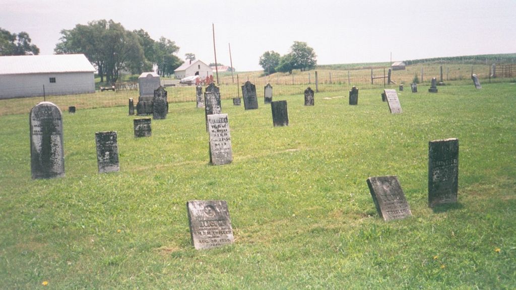
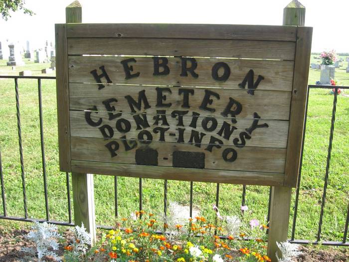
| Description | : | The cemetery is located in Clay Township (NE quadrant of the NW quadrant of the NW quadrant of Section 30 Township 11N Range 9E) on the south side of W County Road 300 N about 0.3 miles west of its intersection with N County Road 450 W. Indiana Cemetery Locations, Volume 3, published by the Indiana Genealogical Society (April 2007), gives the primary cemetery name as Mount Hebron Cemetery. The cemetery is listed in the Cemetery and Burial Grounds Registry of the Indiana Department of Natural Resources (DNR) and in the State Historical Architectural and Archaeological Research Database... Read More |
frequently asked questions (FAQ):
-
Where is Hebron Cemetery?
Hebron Cemetery is located at W County Road 300 N Clay Township, Decatur County ,Indiana , 47240USA.
-
Hebron Cemetery cemetery's updated grave count on graveviews.com?
0 memorials
-
Where are the coordinates of the Hebron Cemetery?
Latitude: 39.3797112
Longitude: -85.5701218
Nearby Cemetories:
1. Mount Moriah Cemetery
Adams Township, Decatur County, USA
Coordinate: 39.3916512, -85.5500870
2. Salem Cemetery
Clay Township, Decatur County, USA
Coordinate: 39.3723270, -85.6065850
3. Clay Township Unidentified Cemetery
Clay Township, Decatur County, USA
Coordinate: 39.3592920, -85.6101250
4. Alley Cemetery
Milford, Decatur County, USA
Coordinate: 39.3593040, -85.6101680
5. Forsythe Cemetery
Greensburg, Decatur County, USA
Coordinate: 39.3524750, -85.5295810
6. Sanford Cemetery
Saint Omer, Decatur County, USA
Coordinate: 39.4216000, -85.5760700
7. Milford Cemetery
Milford, Decatur County, USA
Coordinate: 39.3508415, -85.6178970
8. Mowrey Cemetery
Clay Township, Decatur County, USA
Coordinate: 39.3328018, -85.5792007
9. Union Chapel Cemetery
Saint Paul, Decatur County, USA
Coordinate: 39.4023209, -85.6249542
10. Shiloh Cemetery
Decatur County, USA
Coordinate: 39.3949960, -85.5109260
11. Star Baptist Cemetery
Adams Township, Decatur County, USA
Coordinate: 39.4303093, -85.5552292
12. Jones Cemetery
Noble Township, Shelby County, USA
Coordinate: 39.3647003, -85.6393967
13. Copeland Cemetery
Noble Township, Shelby County, USA
Coordinate: 39.3643990, -85.6402969
14. Gullion Headstone
Downeyville, Decatur County, USA
Coordinate: 39.4130500, -85.5081830
15. Ridlen Cemetery
Saint Paul, Decatur County, USA
Coordinate: 39.4213333, -85.6251984
16. Barr Family Cemetery
Burney, Decatur County, USA
Coordinate: 39.3204470, -85.5838830
17. Saint Omer Cemetery
Decatur County, USA
Coordinate: 39.4380684, -85.5982132
18. McDaniel Cemetery
Adams Township, Decatur County, USA
Coordinate: 39.4418259, -85.5818634
19. Mitchell Cemetery
Noble Township, Shelby County, USA
Coordinate: 39.3680140, -85.6500470
20. Saint Paul Catholic Cemetery
Saint Paul, Decatur County, USA
Coordinate: 39.4251747, -85.6296463
21. Paul Hill Cemetery
Saint Paul, Decatur County, USA
Coordinate: 39.4294205, -85.6240387
22. Pumphrey Cemetery
Milford, Decatur County, USA
Coordinate: 39.3403470, -85.6374460
23. Reed Cemetery
Shelby County, USA
Coordinate: 39.4085999, -85.6492004
24. Mount Cemetery
Geneva, Shelby County, USA
Coordinate: 39.3719760, -85.6606420