
| Memorials | : | 0 |
| Location | : | Marion, Franklin County, USA |
| Coordinate | : | 39.8549840, -77.7124980 |
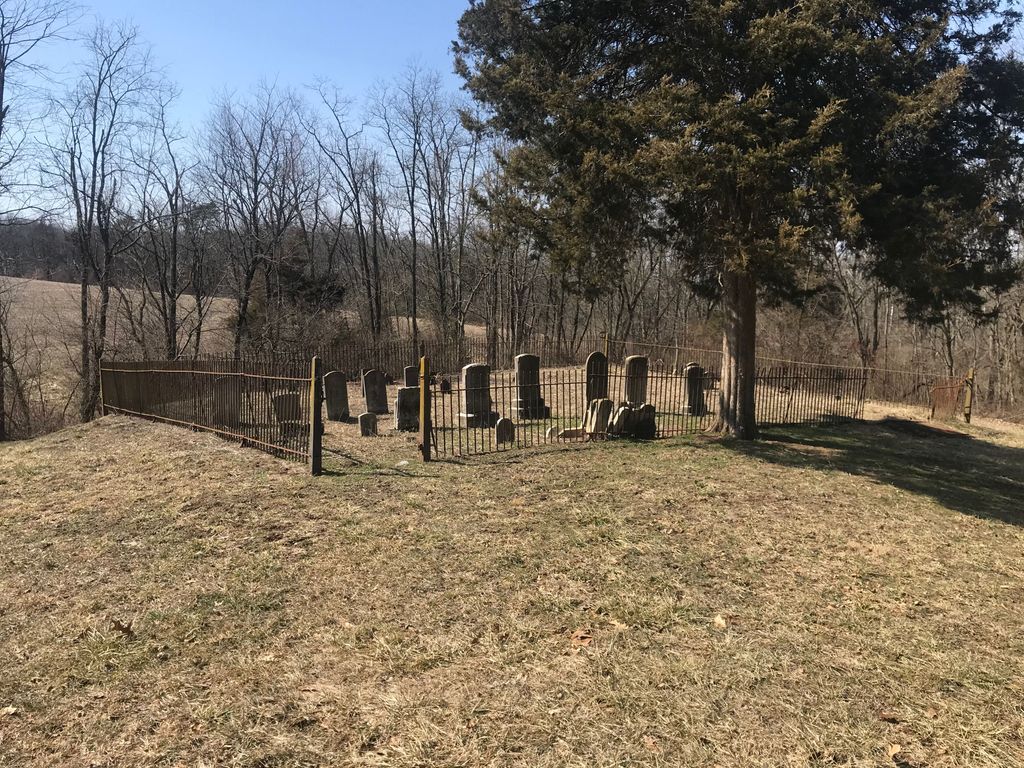
| Description | : | This cemetery is located on the brow of a low hill approximately 500 yards south of Feaster Road and approximately 0.1 mile west of the village of Marion, Guilford Township, Franklin County, Pennsylvania. According to local tradition, this area was formerly known as "Honey Locust". The cemetery can be easily accessed by turning off Molly Pitcher Hwy. (Rte. 11), at the south end of Marion, PA onto Feaster Road (west), on the left just past 58 Feaster Road (south side) pull into the old lane that follows the property line with 58 Feaster Road, this lane is accessible for a short... Read More |
frequently asked questions (FAQ):
-
Where is Hege Cemetery?
Hege Cemetery is located at 157 Feaster Road, Chambersburg, PA Marion, Franklin County ,Pennsylvania , 17202USA.
-
Hege Cemetery cemetery's updated grave count on graveviews.com?
0 memorials
-
Where are the coordinates of the Hege Cemetery?
Latitude: 39.8549840
Longitude: -77.7124980
Nearby Cemetories:
1. Marion United Brethren in Christ Church Cemetery
Guilford, Franklin County, USA
Coordinate: 39.8588000, -77.7022000
2. Maplewood Cemetery
Marion, Franklin County, USA
Coordinate: 39.8578000, -77.6990000
3. Salem Evangelical Lutheran Church Cemetery
Marion, Franklin County, USA
Coordinate: 39.8725000, -77.6929500
4. Cashtown Cemetery
Cashtown, Franklin County, USA
Coordinate: 39.8676290, -77.7382710
5. Brown's Mill Dunkard Cemetery
Franklin County, USA
Coordinate: 39.8311250, -77.7034800
6. Browns Mill Presbyterian Cemetery
Kauffman, Franklin County, USA
Coordinate: 39.8305817, -77.7022400
7. Marion Mennonite Church Cemetery
Chambersburg, Franklin County, USA
Coordinate: 39.8747000, -77.6877000
8. Calvary Mennonite Church Cemetery
Chambersburg, Franklin County, USA
Coordinate: 39.8698570, -77.6753380
9. Cedar Valley Mennonite Church Cemetery
Franklin County, USA
Coordinate: 39.8509660, -77.6652000
10. Samuel Miller Farm Cemetery
Marion, Franklin County, USA
Coordinate: 39.8793300, -77.6707300
11. Enoch Brown Monument
Greencastle, Franklin County, USA
Coordinate: 39.8247950, -77.7538990
12. Plum-Schneider Farm Cemetery
Franklin County, USA
Coordinate: 39.8663000, -77.7705000
13. Ebenezer United Brethren Cemetery
Greencastle, Franklin County, USA
Coordinate: 39.8313000, -77.7668000
14. Antrim Mennonite Cemetery
Greencastle, Franklin County, USA
Coordinate: 39.8051000, -77.7000000
15. Corporal William H Rihl Monument
Greencastle, Franklin County, USA
Coordinate: 39.8038180, -77.7228180
16. Browns Mill Old Baptist Brethren Church Cemetery
Chambersburg, Franklin County, USA
Coordinate: 39.8221000, -77.6579000
17. Kuhn Farm Family Cemetery
Greencastle, Franklin County, USA
Coordinate: 39.8229220, -77.7832660
18. Mower Farm Family Cemetery
Greencastle, Franklin County, USA
Coordinate: 39.8227930, -77.7833300
19. Moss Spring Cemetery
Greencastle, Franklin County, USA
Coordinate: 39.7910000, -77.7166000
20. Evangelical Lutheran Cemetery
Greencastle, Franklin County, USA
Coordinate: 39.7916000, -77.7246000
21. Hades Church Cemetery
Shady Grove, Franklin County, USA
Coordinate: 39.8205200, -77.6394700
22. Grindstone Hill Cemetery
Chambersburg, Franklin County, USA
Coordinate: 39.8584100, -77.6267200
23. Cedar Hill Cemetery
Greencastle, Franklin County, USA
Coordinate: 39.7924995, -77.7442017
24. German Reformed Cemetery
Greencastle, Franklin County, USA
Coordinate: 39.7880000, -77.7288000