
| Memorials | : | 0 |
| Location | : | Herzele, Arrondissement Aalst, Belgium |
| Coordinate | : | 50.8872400, 3.8894900 |
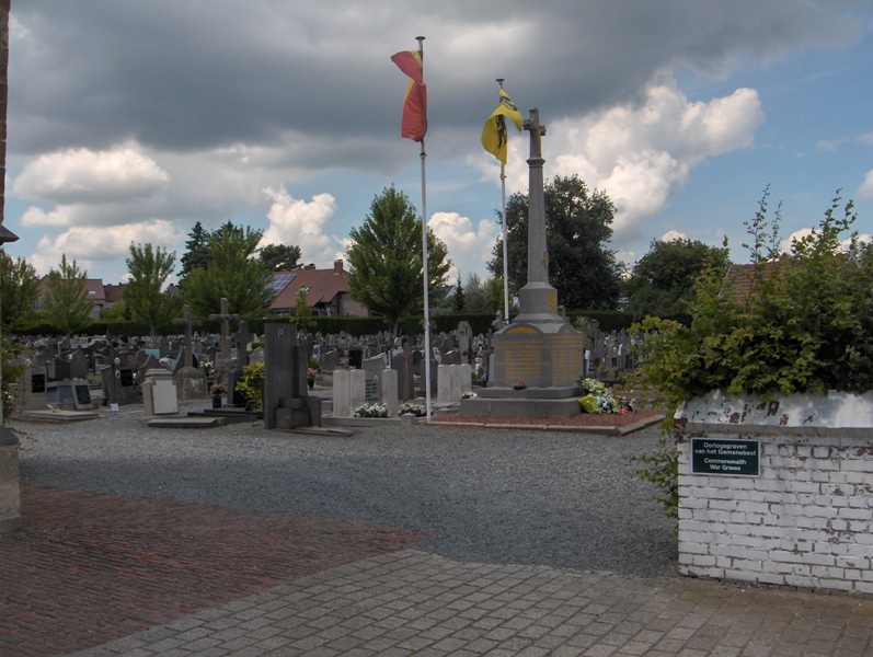
| Description | : | The village of Herzele is located south-west of the town of Aalst off the N46. From the motorway E40/A10, which runs between Oostende and Brussels, turn off at junction 18 onto the N46, direction Hillegem. Go through the village of Borsbeke and at the next crossroads turn left into Stationstraat towards Herzele. Follow this road to the village centre and the church is on the right. The graves are located to the right of the church. The eight Commonwealth burials of the First World War in Herzele Churchyard resulted from a railway accident on 7 December 1918. The grave... Read More |
frequently asked questions (FAQ):
-
Where is Herzele Churchyard?
Herzele Churchyard is located at Herzele, Arrondissement Aalst ,East Flanders (Oost-Vlaanderen) ,Belgium.
-
Herzele Churchyard cemetery's updated grave count on graveviews.com?
0 memorials
-
Where are the coordinates of the Herzele Churchyard?
Latitude: 50.8872400
Longitude: 3.8894900
Nearby Cemetories:
1. Borsbeke Communal Cemetery
Herzele, Arrondissement Aalst, Belgium
Coordinate: 50.9081900, 3.8923100
2. Woubrechtegem Communal Cemetery
Herzele, Arrondissement Aalst, Belgium
Coordinate: 50.8726200, 3.9159100
3. Saint Lievens-Esse Churchyard
Herzele, Arrondissement Aalst, Belgium
Coordinate: 50.8567900, 3.8846900
4. Aaigem Communal Cemetery
Erpe-Mere, Arrondissement Aalst, Belgium
Coordinate: 50.8882670, 3.9426540
5. Burst Communal Cemetery
Burst, Arrondissement Aalst, Belgium
Coordinate: 50.9145919, 3.9216688
6. Heldergem
Haaltert, Arrondissement Aalst, Belgium
Coordinate: 50.8848420, 3.9529540
7. Elene Churchyard
Zottegem, Arrondissement Aalst, Belgium
Coordinate: 50.8890390, 3.8094650
8. Zottegem Communal Cemetery Old
Zottegem, Arrondissement Aalst, Belgium
Coordinate: 50.8635368, 3.8140651
9. Mere Communal Cemetery
Erpe-Mere, Arrondissement Aalst, Belgium
Coordinate: 50.9168300, 3.9721200
10. Bavegem
Sint-Lievens-Houtem, Arrondissement Aalst, Belgium
Coordinate: 50.9446300, 3.8612300
11. Aspelare Cemetery
Ninove, Arrondissement Aalst, Belgium
Coordinate: 50.8377700, 3.9551400
12. Ophasselt Churchyard
Geraardsbergen, Arrondissement Aalst, Belgium
Coordinate: 50.8219310, 3.8956890
13. Erondegem Communal Cemetery
Erpe-Mere, Arrondissement Aalst, Belgium
Coordinate: 50.9388700, 3.9547900
14. Kerksken Cemetery
Haaltert, Arrondissement Aalst, Belgium
Coordinate: 50.8916200, 3.9941900
15. Velzeke Communal Cemetery
Velzeke-Ruddershove, Arrondissement Aalst, Belgium
Coordinate: 50.8838744, 3.7842388
16. Erpe Communal Cemetery
Erpe-Mere, Arrondissement Aalst, Belgium
Coordinate: 50.9317390, 3.9749690
17. Oordegem Communal Cemetery
Lede, Arrondissement Aalst, Belgium
Coordinate: 50.9573800, 3.9079500
18. Sint Maria Lierde Cemetery
Lierde, Arrondissement Oudenaarde, Belgium
Coordinate: 50.8217400, 3.8451100
19. Balegem Nieuw Communal Cemetery
Oosterzele, Arrondissement Gent, Belgium
Coordinate: 50.9273720, 3.7929010
20. Balegem Oud Churchyard
Oosterzele, Arrondissement Gent, Belgium
Coordinate: 50.9262610, 3.7888880
21. Voorde Ninove Churchyard
Ninove, Arrondissement Aalst, Belgium
Coordinate: 50.8229840, 3.9495960
22. Haaltert Communal Cemetery
Haaltert, Arrondissement Aalst, Belgium
Coordinate: 50.8968500, 4.0123900
23. Zottegem Communal Cemetery
Zottegem, Arrondissement Aalst, Belgium
Coordinate: 50.8685500, 3.7687100
24. Oosterzele Centrum Churchyard
Oosterzele, Arrondissement Gent, Belgium
Coordinate: 50.9446930, 3.8033290