
| Memorials | : | 0 |
| Location | : | Cainsville, Wilson County, USA |
| Coordinate | : | 35.9878930, -86.2280820 |
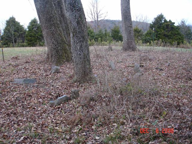
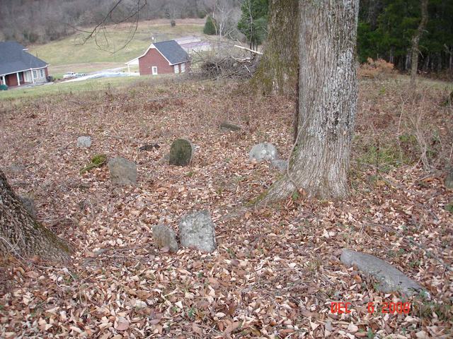
| Description | : | This is the family cemetery of Joseph and Sarah Mount Hight. The earliest identified burial is probably that of Telitha Harris (no dates visible), daughter of Richard and Polly Mount. Richard and Polly Mount are also buried here, on property once owned by their son-in-law. No marker has yet been identified for Sarah Mount. There were only five stones transcribed in the 1970s, the rest being unmarked fieldstones, sunken or otherwise no longer readable individual stones. In 2013, all five were still readable, except for dates on Telitha Harris' stone. The cemetery is on private property on... Read More |
frequently asked questions (FAQ):
-
Where is Hight-Mount Family Cemetery?
Hight-Mount Family Cemetery is located at Cainsville, Wilson County ,Tennessee ,USA.
-
Hight-Mount Family Cemetery cemetery's updated grave count on graveviews.com?
0 memorials
-
Where are the coordinates of the Hight-Mount Family Cemetery?
Latitude: 35.9878930
Longitude: -86.2280820
Nearby Cemetories:
1. Harris Cemetery
Cainsville, Wilson County, USA
Coordinate: 35.9720880, -86.2165710
2. George Martin Cemetery
Wilson County, USA
Coordinate: 35.9683000, -86.2328000
3. Patterson Cemetery
Greenvale, Wilson County, USA
Coordinate: 36.0096810, -86.2284440
4. Cason Cemetery
Cainsville, Wilson County, USA
Coordinate: 35.9741780, -86.2574500
5. Lester-Clemmons Cemetery
Cainsville, Wilson County, USA
Coordinate: 36.0012600, -86.2619200
6. Dillon-Jennings Cemetery
Greenvale, Wilson County, USA
Coordinate: 35.9868330, -86.1878390
7. Greenvale Cemetery
Greenvale, Wilson County, USA
Coordinate: 36.0088997, -86.1971970
8. Phillips Cemetery
Cainsville, Wilson County, USA
Coordinate: 35.9880310, -86.2724930
9. Jarmen Cemetery
Rutherford County, USA
Coordinate: 35.9631004, -86.2643967
10. Jarmen Cemetery
Rutherford County, USA
Coordinate: 35.9561005, -86.2608032
11. Arnold-Sellars Cemetery
Cainsville, Wilson County, USA
Coordinate: 36.0247450, -86.2644120
12. Donnell Cemetery
Rutherford County, USA
Coordinate: 35.9399986, -86.2660980
13. Alsup-Rucker Cemetery
Wilson County, USA
Coordinate: 36.0151960, -86.3087090
14. Cedar Forest Road Cemetery
Wilson County, USA
Coordinate: 36.0314311, -86.2978137
15. Comer Family Cemetery
Wilson County, USA
Coordinate: 35.9996200, -86.3199590
16. Johns Cemetery
Rutherford County, USA
Coordinate: 35.9578018, -86.3214035
17. Alsup Cemetery
Wilson County, USA
Coordinate: 36.0027950, -86.3293580
18. Alsup Cemetery
Wilson County, USA
Coordinate: 36.0131120, -86.3326100
19. Johns Cemetery
Rutherford County, USA
Coordinate: 35.9743996, -86.3439026
20. Floyd Cemetery
Halls Hill, Rutherford County, USA
Coordinate: 35.8918991, -86.2244034
21. Donnell Cemetery
Auburntown, Cannon County, USA
Coordinate: 35.9427986, -86.1224976
22. Floyd-Alexander Cemetery
Halls Hill, Rutherford County, USA
Coordinate: 35.8866997, -86.2244034
23. Cunningham Cemetery
Cherry Valley, Wilson County, USA
Coordinate: 36.0884250, -86.2012040
24. Elrod Cemetery
Halls Hill, Rutherford County, USA
Coordinate: 35.8861008, -86.1928024