
| Memorials | : | 0 |
| Location | : | Kesgrave, Suffolk Coastal District, England |
| Phone | : | +44 1473 728115 |
| Coordinate | : | 52.0663330, 1.2499040 |
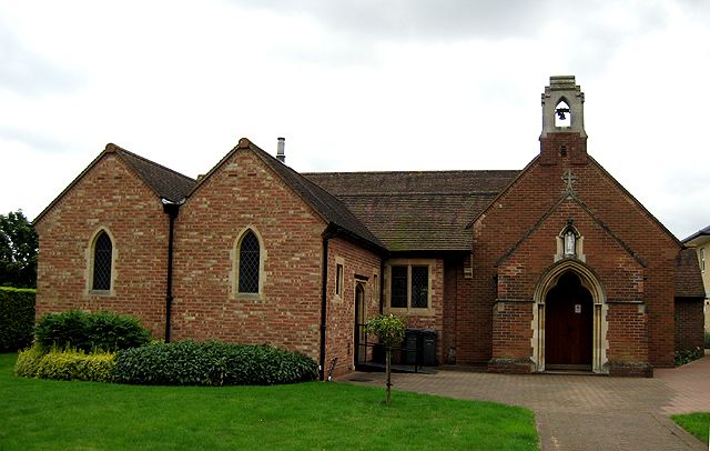
| Description | : | St Michael and the Holy Family, Kesgrave, is a modern Roman Catholic church built in 1931 as a memorial chapel for Michael Rope, aeronautical engineer, who died in the crash of the R101 airship in 1930. The church has been twice extended and now serves Catholics from a wide area. There are two graves in the small churchyard -- Lucy Doreen Rope, founder of the church, and Margaret Edith Aldrich Rope, the artist. |
frequently asked questions (FAQ):
-
Where is Holy Family and St. Michael Churchyard?
Holy Family and St. Michael Churchyard is located at Main Rd Kesgrave, Suffolk Coastal District ,Suffolk , IP5 2QPEngland.
-
Holy Family and St. Michael Churchyard cemetery's updated grave count on graveviews.com?
0 memorials
-
Where are the coordinates of the Holy Family and St. Michael Churchyard?
Latitude: 52.0663330
Longitude: 1.2499040
Nearby Cemetories:
1. All Saints Churchyard
Kesgrave, Suffolk Coastal District, England
Coordinate: 52.0658710, 1.2356100
2. Dobbs Grave
Kesgrave, Suffolk Coastal District, England
Coordinate: 52.0577557, 1.2609540
3. All Saints Churchyard
Little Bealings, Suffolk Coastal District, England
Coordinate: 52.0854520, 1.2525230
4. All Saints
Little Bealings, Suffolk Coastal District, England
Coordinate: 52.0854660, 1.2522380
5. St Mary Churchyard
Playford, Suffolk Coastal District, England
Coordinate: 52.0866990, 1.2354930
6. St. Mary's Churchyard
Great Bealings, Suffolk Coastal District, England
Coordinate: 52.0930240, 1.2554220
7. St John the Baptist Churchyard
Brightwell, Suffolk Coastal District, England
Coordinate: 52.0445610, 1.2792080
8. St Andrew's Churchyard
Rushmere St Andrew, Suffolk Coastal District, England
Coordinate: 52.0692520, 1.2028210
9. St. Mary's Churchyard
Martlesham, Suffolk Coastal District, England
Coordinate: 52.0742350, 1.3000490
10. St Botolph's Churchyard
Culpho, Suffolk Coastal District, England
Coordinate: 52.0963570, 1.2253710
11. St Mary Churchyard
Bucklesham, Suffolk Coastal District, England
Coordinate: 52.0316100, 1.2699200
12. Baptist Chapelyard
Grundisburgh, Suffolk Coastal District, England
Coordinate: 52.1058380, 1.2499810
13. St Augustine's Church Burial Ground
Ipswich, Ipswich Borough, England
Coordinate: 52.0415210, 1.1987350
14. St Martin Churchyard
Tuddenham St Martin, Suffolk Coastal District, England
Coordinate: 52.0906080, 1.1977240
15. Seven Hills Crematorium
Nacton, Suffolk Coastal District, England
Coordinate: 52.0252130, 1.2489840
16. Millennium Cemetery
Ipswich, Ipswich Borough, England
Coordinate: 52.0764320, 1.1793140
17. St Andrew Churchyard
Hasketon, Suffolk Coastal District, England
Coordinate: 52.1063910, 1.2845520
18. Lawn Cemetery
Ipswich, Ipswich Borough, England
Coordinate: 52.0702740, 1.1747850
19. Ipswich Crematorium
Ipswich, Ipswich Borough, England
Coordinate: 52.0688070, 1.1739190
20. St Mary the Virgin
Grundisburgh, Suffolk Coastal District, England
Coordinate: 52.1130840, 1.2460330
21. St. Mary's Churchyard
Newbourne, Suffolk Coastal District, England
Coordinate: 52.0392970, 1.3127700
22. New Ipswich Cemetery
Ipswich, Ipswich Borough, England
Coordinate: 52.0677840, 1.1720420
23. Old Ipswich Cemetery
Ipswich, Ipswich Borough, England
Coordinate: 52.0645820, 1.1678390
24. Holy Trinity Churchyard
Ipswich, Ipswich Borough, England
Coordinate: 52.0525390, 1.1660850