
| Memorials | : | 0 |
| Location | : | Bowdon, Carroll County, USA |
| Coordinate | : | 33.6045200, -85.2770600 |
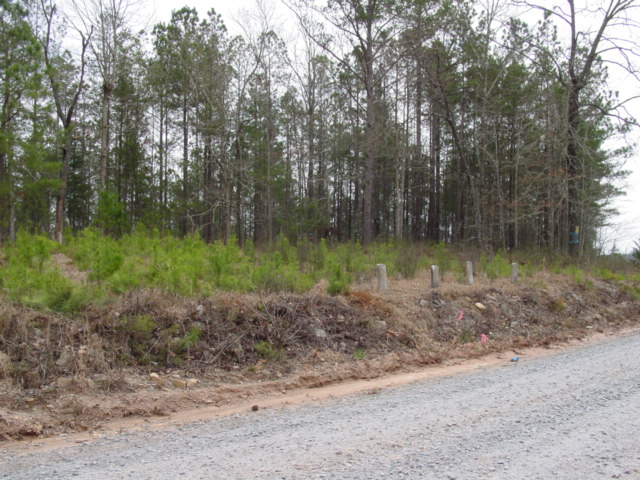
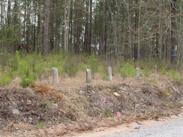
| Description | : | From the intersection of Highway 100 and 166 in Bowdon, turn north on Highway 100. Go about 3.0 miles and turn left on Smithfield Road. Continue 1.6 miles to Teague Road (a dirt road just past Poplar Springs Primitive Baptist Church) and turn right. The cemetery is about 1.3 miles on the right side of road. The family historian for the Gabriel Smith family states that the Revolutionary War Soldier, is buried in a unmarked grave. He drew nearby land in the land lottery for his service, and the community became known as Smithfield. There are only 7 headstones. There are approximately... Read More |
frequently asked questions (FAQ):
-
Where is Horsley Cemetery?
Horsley Cemetery is located at Smithfield Bowdon, Carroll County ,Georgia ,USA.
-
Horsley Cemetery cemetery's updated grave count on graveviews.com?
0 memorials
-
Where are the coordinates of the Horsley Cemetery?
Latitude: 33.6045200
Longitude: -85.2770600
Nearby Cemetories:
1. Poplar Springs Primitive Baptist Church Cemetery
Carroll County, USA
Coordinate: 33.6013985, -85.2735977
2. Kansas Missionary Baptist Church Cemetery
Carroll County, USA
Coordinate: 33.6225014, -85.2699966
3. Indian Creek Cemetery
Bowdon, Carroll County, USA
Coordinate: 33.5792007, -85.2542038
4. Garretts Chapel United Methodist Church Cemetery
Five Points, Carroll County, USA
Coordinate: 33.5942001, -85.3131027
5. Wright Cemetery
Bowdon, Carroll County, USA
Coordinate: 33.6126180, -85.3139880
6. Mountain View Baptist Church Cemetery
Bowdon, Carroll County, USA
Coordinate: 33.6189003, -85.3221970
7. Johnson-Smith Cemetery
Bowdon, Carroll County, USA
Coordinate: 33.5781220, -85.2383710
8. Smith Chapel Cemetery
Carroll County, USA
Coordinate: 33.6006012, -85.2193985
9. Shiloh Primitive Baptist Church Cemetery
Waco, Haralson County, USA
Coordinate: 33.6607820, -85.2781750
10. Antioch Baptist Church Cemetery
Waco, Haralson County, USA
Coordinate: 33.6612900, -85.2830000
11. Community Memory Gardens
Bowdon, Carroll County, USA
Coordinate: 33.5630989, -85.2238998
12. Macedonia Baptist Church Cemetery
Macedonia, Cleburne County, USA
Coordinate: 33.5792007, -85.3455963
13. Holmes Cemetery
Mount Zion, Carroll County, USA
Coordinate: 33.6112090, -85.2017780
14. Liberty Baptist Church Cemetery
Bowdon, Carroll County, USA
Coordinate: 33.5412020, -85.2749640
15. Bowdon Church of God Cemetery
Bowdon, Carroll County, USA
Coordinate: 33.5412870, -85.2717590
16. Bowdon City Cemetery
Bowdon, Carroll County, USA
Coordinate: 33.5424995, -85.2564011
17. Bowdon Baptist Cemetery
Bowdon, Carroll County, USA
Coordinate: 33.5396996, -85.2574997
18. Bowdon Methodist Protestant Church Cemetery
Bowdon, Carroll County, USA
Coordinate: 33.5388180, -85.2604980
19. Shiloh United Methodist Church Cemetery
Carroll County, USA
Coordinate: 33.5752983, -85.2043991
20. Five Points Baptist Church Cemetery
Carroll County, USA
Coordinate: 33.6514015, -85.2182999
21. Union Camp Ground Cemetery
Carroll County, USA
Coordinate: 33.6563988, -85.2210999
22. Union United Methodist Church Cemetery
Waco, Haralson County, USA
Coordinate: 33.6564580, -85.2210380
23. McBurnett Cemetery
Mount Zion, Carroll County, USA
Coordinate: 33.6506720, -85.2124070
24. Bowdon First United Methodist Cemetery
Bowdon, Carroll County, USA
Coordinate: 33.5355988, -85.2549973