
| Memorials | : | 12 |
| Location | : | Woodstock, Oxford County Municipality, Canada |
| Coordinate | : | 43.1476245, -80.7873872 |
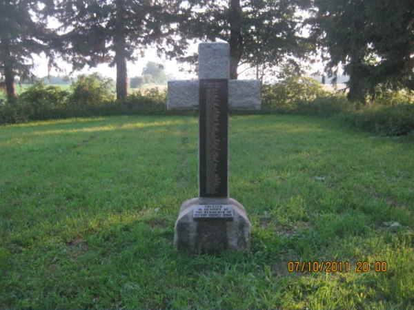
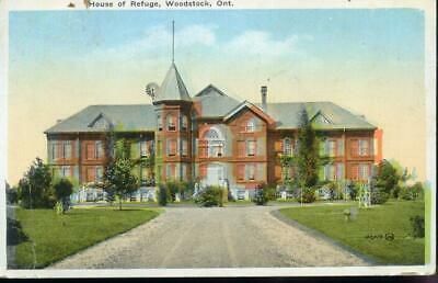
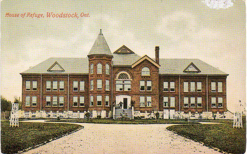
| Description | : | This cemetery is located on the west side of Fanshawe Road #515137 (County Road # 30) north of Dundas (Highway 2) at the west end of Woodstock Lot 3 Concession 10. ERECTED IN MEMORY OF THE RESIDENTS OF OXFORD COUNTY HOME 1895 - 1956 There are no stones in the House of Refuge Cemetery, only a large Cross which the County has erected with the names of people buried there. Many of the residents were claimed by family and buried at other cemeteries in the County. Residents of the House of Refuge & Oxford County Industrial Farm were buried here between 1895-1956. |
frequently asked questions (FAQ):
-
Where is House of Refuge Cemetery?
House of Refuge Cemetery is located at County Road 30 Woodstock, Oxford County Municipality ,Ontario ,Canada.
-
House of Refuge Cemetery cemetery's updated grave count on graveviews.com?
8 memorials
-
Where are the coordinates of the House of Refuge Cemetery?
Latitude: 43.1476245
Longitude: -80.7873872
Nearby Cemetories:
1. Anglican Cemetery
Woodstock, Oxford County Municipality, Canada
Coordinate: 43.1426000, -80.7653300
2. Woodstock Baptist Cemetery
Woodstock, Oxford County Municipality, Canada
Coordinate: 43.1416460, -80.7655790
3. Woodstock Presbyterian Cemetery
Woodstock, Oxford County Municipality, Canada
Coordinate: 43.1409440, -80.7651600
4. Hillview Cemetery
Woodstock, Oxford County Municipality, Canada
Coordinate: 43.1206703, -80.7675400
5. Old St. Paul's Anglican Cemetery
Woodstock, Oxford County Municipality, Canada
Coordinate: 43.1325600, -80.7462300
6. Oxford Memorial Park Cemetery
Woodstock, Oxford County Municipality, Canada
Coordinate: 43.1148200, -80.8150400
7. Saint Marys Roman Catholic Cemetery
Woodstock, Oxford County Municipality, Canada
Coordinate: 43.1089400, -80.7998900
8. Huntingford Christ Church Anglican Cemetery
Huntingford, Oxford County Municipality, Canada
Coordinate: 43.2000280, -80.7960970
9. Old Log Church Cemetery
Embro, Oxford County Municipality, Canada
Coordinate: 43.1529121, -80.8626785
10. Vandecar Cemetery
Vandecar, Oxford County Municipality, Canada
Coordinate: 43.2010640, -80.8148020
11. Beachville Cemetery
Beachville, Oxford County Municipality, Canada
Coordinate: 43.0889511, -80.8313599
12. Sweaburg Union Cemetery
Sweaburg, Oxford County Municipality, Canada
Coordinate: 43.0690800, -80.7623200
13. Methodist Cemetery
Embro, Oxford County Municipality, Canada
Coordinate: 43.1495018, -80.8983841
14. North Embro Cemetery
Embro, Oxford County Municipality, Canada
Coordinate: 43.1667920, -80.9040350
15. Innerkip Cemetery
Innerkip, Oxford County Municipality, Canada
Coordinate: 43.2050000, -80.6929000
16. Pleasant View Cemetery
Curries, Oxford County Municipality, Canada
Coordinate: 43.0716390, -80.7196470
17. Oxford Centre Christ Church Anglican Cemetery
Oxford Centre, Oxford County Municipality, Canada
Coordinate: 43.0996310, -80.6814490
18. East Oxford Pioneer Cemetery
Oxford Centre, Oxford County Municipality, Canada
Coordinate: 43.0999370, -80.6804350
19. Saint Johns Anglican Cemetery
Eastwood, Oxford County Municipality, Canada
Coordinate: 43.1443080, -80.6575850
20. West Oxford United Church Cemetery
Centreville, Oxford County Municipality, Canada
Coordinate: 43.0521710, -80.8451320
21. Red Star Cemetery
Embro, Oxford County Municipality, Canada
Coordinate: 43.1124175, -80.9326897
22. Ingersoll Rural Cemetery
Ingersoll, Oxford County Municipality, Canada
Coordinate: 43.0545040, -80.8732690
23. Sacred Heart Cemetery
Ingersoll, Oxford County Municipality, Canada
Coordinate: 43.0514300, -80.8917200
24. Scottish Pioneer
Holiday, Oxford County Municipality, Canada
Coordinate: 43.1334100, -80.9626100