
| Memorials | : | 0 |
| Location | : | West Des Moines, Polk County, USA |
| Coordinate | : | 41.5615200, -93.7347200 |
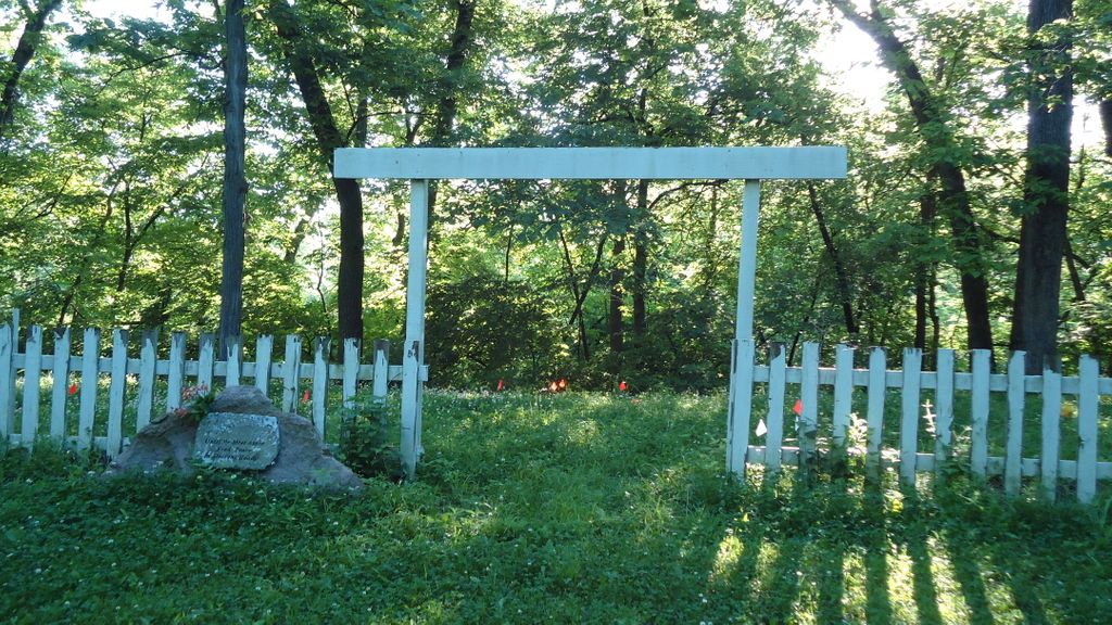
| Description | : | This cemetery is north and slighty west of Jordan House (2001 Fuller Road), on the grounds of Jordan Park Camp. If interested in visiting it would be a good idea to contact the camp first. This was originally the Jordan family cemetery, which was the original burial site for most of the Jordan family members and other Walnut Township pioneers, but it was abandoned for modern day Jordan Cemetery. The members of the Jordan family that were buried here were later removed to Jordan Cemetery, and all that remains are 6 or more graves. The stones were smashed... Read More |
frequently asked questions (FAQ):
-
Where is Jordan Family Cemetery?
Jordan Family Cemetery is located at 2251 Fuller Road West Des Moines, Polk County ,Iowa , 50265USA.
-
Jordan Family Cemetery cemetery's updated grave count on graveviews.com?
0 memorials
-
Where are the coordinates of the Jordan Family Cemetery?
Latitude: 41.5615200
Longitude: -93.7347200
Nearby Cemetories:
1. Oak Hill Cemetery
West Des Moines, Polk County, USA
Coordinate: 41.5614500, -93.7356910
2. Jordan Cemetery
West Des Moines, Polk County, USA
Coordinate: 41.5588989, -93.7450027
3. Resthaven Cemetery
West Des Moines, Polk County, USA
Coordinate: 41.5806007, -93.7300034
4. West Des Moines Christian Church Memory Garden
West Des Moines, Polk County, USA
Coordinate: 41.5613180, -93.7660090
5. Saint Timothy Espiscopal Church Columbarium
West Des Moines, Polk County, USA
Coordinate: 41.5851000, -93.7390000
6. Benjamin F Jesse Pioneer Cemetery
Des Moines, Polk County, USA
Coordinate: 41.5776360, -93.6931440
7. Jewish Glendale Cemetery
Des Moines, Polk County, USA
Coordinate: 41.6011552, -93.6903870
8. Plymouth Congregational Church Memorial Garden
Des Moines, Polk County, USA
Coordinate: 41.5860000, -93.6729500
9. Glendale Cemetery
Des Moines, Polk County, USA
Coordinate: 41.6008740, -93.6850120
10. Oak Grove Cemetery
Des Moines, Polk County, USA
Coordinate: 41.5485992, -93.6580963
11. Masonic Cemetery
Des Moines, Polk County, USA
Coordinate: 41.6075892, -93.6834133
12. Pleasant Ridge Cemetery
Linn Township, Warren County, USA
Coordinate: 41.5011950, -93.7309600
13. Maffitt Cemetery
Bloomfield Township, Polk County, USA
Coordinate: 41.5128200, -93.7855680
14. Grace United Methodist Church Memorial Garden
Des Moines, Polk County, USA
Coordinate: 41.5980000, -93.6673000
15. Saint Lukes Episcopal Church Garden
Des Moines, Polk County, USA
Coordinate: 41.6039162, -93.6644135
16. Saint John's Cemetery
Linn Township, Warren County, USA
Coordinate: 41.4947750, -93.7599860
17. Grace Lutheran Church Columbarium
Des Moines, Polk County, USA
Coordinate: 41.6226930, -93.6904340
18. Huston Cemetery
Boone Township, Dallas County, USA
Coordinate: 41.5596120, -93.8283660
19. Emanuel Cemetery
Des Moines, Polk County, USA
Coordinate: 41.5917015, -93.6485977
20. Woodland Cemetery
Des Moines, Polk County, USA
Coordinate: 41.5889015, -93.6464005
21. Saint Ambrose Cemetery
Des Moines, Polk County, USA
Coordinate: 41.5932999, -93.6464005
22. Chapel Hill Gardens
Des Moines, Polk County, USA
Coordinate: 41.6389008, -93.7005997
23. Sunset Memorial Gardens
Des Moines, Polk County, USA
Coordinate: 41.5159988, -93.6429977
24. Cathedral Church of Saint Paul Columbarium
Des Moines, Polk County, USA
Coordinate: 41.5878500, -93.6291500