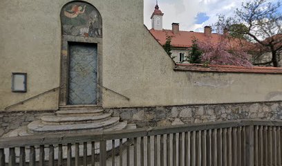
| Memorials | : | 0 |
| Location | : | Graz, Graz Stadt, Austria |
| Coordinate | : | 47.0888570, 15.4334110 |
frequently asked questions (FAQ):
-
Where is Karmeliterkloster des Heiligen Josef?
Karmeliterkloster des Heiligen Josef is located at Grabenstraße 114 Graz, Graz Stadt ,Styria (Steiermark) , 8010Austria.
-
Karmeliterkloster des Heiligen Josef cemetery's updated grave count on graveviews.com?
0 memorials
-
Where are the coordinates of the Karmeliterkloster des Heiligen Josef?
Latitude: 47.0888570
Longitude: 15.4334110
Nearby Cemetories:
1. Kaiser Mausoleum
Graz, Graz Stadt, Austria
Coordinate: 47.0714960, 15.4426790
2. Steinfeld Friedhof
Graz, Graz Stadt, Austria
Coordinate: 47.0668180, 15.4164380
3. Sankt Leonhard Friedhof
Graz, Graz Stadt, Austria
Coordinate: 47.0773340, 15.4662960
4. Sankt-Peter Friedhof
Graz, Graz Stadt, Austria
Coordinate: 47.0624690, 15.4614760
5. röm.kath. Friedhof St. Margarethen an der Raab
Sankt Margarethen an der Raab, Weiz Bezirk, Austria
Coordinate: 47.0704275, 15.3889345
6. Urnenfriedhof
Graz Stadt, Austria
Coordinate: 47.0477000, 15.4219000
7. Altkatholischer Friedhof
Graz, Graz Stadt, Austria
Coordinate: 47.0468396, 15.4287204
8. Evangelischer Friedhof Neuhart
Strassgang, Graz Stadt, Austria
Coordinate: 47.0485483, 15.4088464
9. Zentralfriedhof
Graz, Graz Stadt, Austria
Coordinate: 47.0451970, 15.4263540
10. Friedhof Maria Trost
Mariatrost, Graz Stadt, Austria
Coordinate: 47.1070190, 15.4929120
11. Sankt Peter Ostfriedhof
Graz Stadt, Austria
Coordinate: 47.0556071, 15.4781579
12. Thal bei Graz
Thal, Graz-Umgebung Bezirk, Austria
Coordinate: 47.0743079, 15.3566463
13. Judendorf Strassengel
Strassengel, Graz-Umgebung Bezirk, Austria
Coordinate: 47.1112490, 15.3391360
14. Saint Stefan Friedhof
Gratkorn, Graz-Umgebung Bezirk, Austria
Coordinate: 47.1337212, 15.3483008
15. St. Radegund
Sankt Radegund bei Graz, Graz-Umgebung Bezirk, Austria
Coordinate: 47.1777425, 15.4873835
16. Kumberg
Kumberg, Graz-Umgebung Bezirk, Austria
Coordinate: 47.1630913, 15.5307448
17. Stift Rein
Eisbach, Graz-Umgebung Bezirk, Austria
Coordinate: 47.1350870, 15.2850560
18. Eggersdorf
Eggersdorf bei Graz, Graz-Umgebung Bezirk, Austria
Coordinate: 47.1205779, 15.5966205
19. Premstätten
Unterpremstatten, Graz-Umgebung Bezirk, Austria
Coordinate: 46.9697797, 15.4022731
20. Pfarrkirche Wundschuh
Wundschuh, Graz-Umgebung Bezirk, Austria
Coordinate: 46.9254029, 15.4476081
21. Katholische Kirche Stübing
Stubinggraben, Graz-Umgebung Bezirk, Austria
Coordinate: 47.1923093, 15.2354414
22. Friedhof Frohnleiten Friedhof
Adriach, Graz-Umgebung Bezirk, Austria
Coordinate: 47.2663082, 15.3116700
23. Friedhof St. Stefan Ob Stainz
Sankt Stefan ob Stainz, Deutschlandsberg Bezirk, Austria
Coordinate: 46.9278821, 15.2526982
24. Friedhof Koflach
Koflach, Voitsberg Bezirk, Austria
Coordinate: 47.0669252, 15.0863363

