
| Memorials | : | 0 |
| Location | : | Helferskirchen, Westerwaldkreis, Germany |
| Coordinate | : | 50.5133620, 7.8149060 |
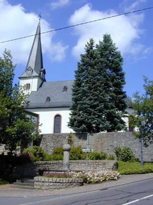
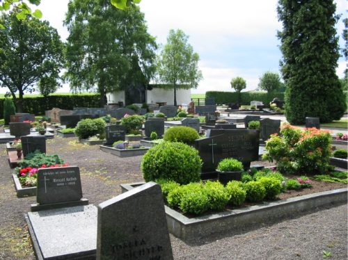
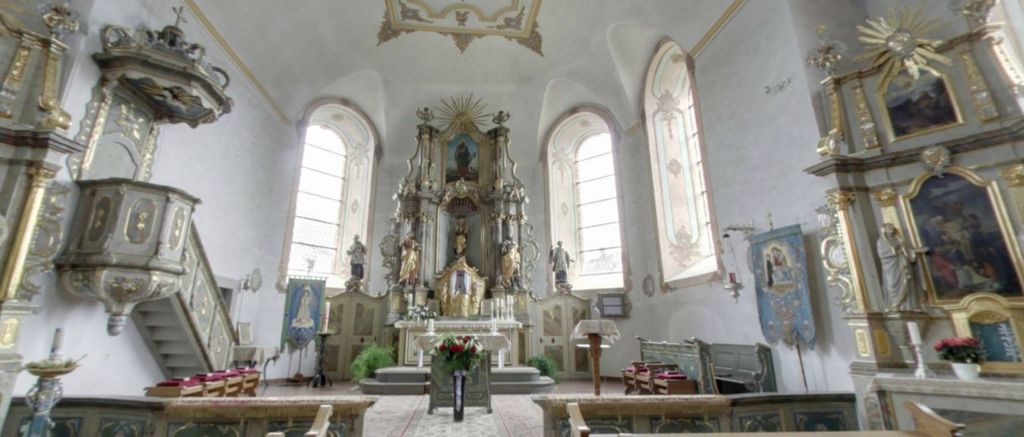
| Description | : | The Catholic Church "Assumption of the Mary" was built in Helferskirchen 930-959 as a "fortress church" and in 1222 re-established. The present church was built in 1769. Its precursors were wooden churches first built in 1222. The present church was built with a Romanesque west tower with octagonal spire and late-Gothic building from the early 13th Century. With its fully preserved baroque interior decoration and paintings it is considered one of the most beautiful baroque churches in the Westerwald. Cemetery is next to the Assumption of Mary Catholic Church, in Helferskirchen. |
frequently asked questions (FAQ):
-
Where is Katholische Maria Himmelfahrt?
Katholische Maria Himmelfahrt is located at Hauptstr 5 Helferskirchen, Westerwaldkreis ,Rheinland-Pfalz , 56244Germany.
-
Katholische Maria Himmelfahrt cemetery's updated grave count on graveviews.com?
0 memorials
-
Where are the coordinates of the Katholische Maria Himmelfahrt?
Latitude: 50.5133620
Longitude: 7.8149060
Nearby Cemetories:
1. Katholische Friedhof Wirges
Wirges, Westerwaldkreis, Germany
Coordinate: 50.4728530, 7.8007220
2. Jüdischer Friedhof (Meudt)
Meudt, Westerwaldkreis, Germany
Coordinate: 50.4929294, 7.8938482
3. Judischer Friedhof
Montabaur, Westerwaldkreis, Germany
Coordinate: 50.4317302, 7.8200077
4. Schloßkirche Westerburg
Westerburg, Westerwaldkreis, Germany
Coordinate: 50.5633740, 7.9743680
5. Evangelische Kirche Alpenrod
Alpenrod, Westerwaldkreis, Germany
Coordinate: 50.6318070, 7.8688430
6. Andachtswald Hachenburg
Hachenburg, Westerwaldkreis, Germany
Coordinate: 50.6514351, 7.8491154
7. Evangelische Kirche Urbach
Landkreis Neuwied, Germany
Coordinate: 50.5633310, 7.5871700
8. Jüdischer Friedhof
Weitersburg, Landkreis Mayen-Koblenz, Germany
Coordinate: 50.4085867, 7.6083097
9. Vallendar Friedhof
Vallendar, Landkreis Mayen-Koblenz, Germany
Coordinate: 50.4037615, 7.6139630
10. Friedhof Weitersburg
Weitersburg, Landkreis Mayen-Koblenz, Germany
Coordinate: 50.4113493, 7.5953938
11. Friedhof Bendorf
Bendorf, Landkreis Mayen-Koblenz, Germany
Coordinate: 50.4220930, 7.5813870
12. Neuer Friedhof
Diez an der Lahn, Rhein-Lahn-Kreis, Germany
Coordinate: 50.3793943, 8.0056283
13. Ehrenfriedhof Diez
Diez an der Lahn, Rhein-Lahn-Kreis, Germany
Coordinate: 50.3786560, 8.0049460
14. Jüdischer Friedhof Bad Ems
Bad Ems, Rhein-Lahn-Kreis, Germany
Coordinate: 50.3422664, 7.7149293
15. Kaiserwald Bad Ems
Bad Ems, Rhein-Lahn-Kreis, Germany
Coordinate: 50.3362980, 7.7307730
16. Friedhof Bad Ems
Bad Ems, Rhein-Lahn-Kreis, Germany
Coordinate: 50.3396900, 7.7130746
17. Altstadtfriedhof
Diez an der Lahn, Rhein-Lahn-Kreis, Germany
Coordinate: 50.3733720, 8.0066160
18. Friedhof Ehrenbreitstein
Koblenz, Stadtkreis Koblenz, Germany
Coordinate: 50.3696490, 7.6238210
19. Jüdischer Friedhof
Diez an der Lahn, Rhein-Lahn-Kreis, Germany
Coordinate: 50.3663810, 8.0047250
20. Evangelische Kirche EKHN
Rhein-Lahn-Kreis, Germany
Coordinate: 50.3708330, 8.0158330
21. Friedhof Engers Süd
Engers, Landkreis Neuwied, Germany
Coordinate: 50.4225667, 7.5471165
22. Friedhof Engers Nord
Engers, Landkreis Neuwied, Germany
Coordinate: 50.4290313, 7.5418685
23. Hauptfriedhof Limburg
Limburg an der Lahn, Landkreis Limburg-Weilburg, Germany
Coordinate: 50.3852400, 8.0485400
24. Horhausen Friedhof
Horhausen, Landkreis Altenkirchen, Germany
Coordinate: 50.5915192, 7.5302842