
| Memorials | : | 0 |
| Location | : | Hirsau, Landkreis Calw, Germany |
| Website | : | www.klosterhirsau.de |
| Coordinate | : | 48.7377780, 8.7322220 |
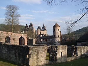
| Description | : | Hirsau Abbey, formerly known as Hirschau Abbey, was once one of the most important Benedictine abbeys of Germany. It is located in the Hirsau borough of Calw on the northern slopes of the Black Forest mountain range, in the present-day state of Baden-Württemberg. In the 11th and 12th century, the monastery was a centre of the Cluniac Reforms, implemented as "Hirsau Reforms" in the German lands. The complex was devastated during the War of the Palatine Succession in 1692 and not rebuilt. |
frequently asked questions (FAQ):
-
Where is Kloster Hirsau?
Kloster Hirsau is located at Klosterhof Hirsau, Landkreis Calw ,Baden-Württemberg , 75365Germany.
-
Kloster Hirsau cemetery's updated grave count on graveviews.com?
0 memorials
-
Where are the coordinates of the Kloster Hirsau?
Latitude: 48.7377780
Longitude: 8.7322220
Nearby Cemetories:
1. Friedhof Hirsau
Hirsau, Landkreis Calw, Germany
Coordinate: 48.7384700, 8.7372900
2. Friedhof Ernstmühl
Ernstmühl, Landkreis Calw, Germany
Coordinate: 48.7483181, 8.7332112
3. Friedhof Ottenbronn
Ottenbronn, Landkreis Calw, Germany
Coordinate: 48.7466080, 8.7499336
4. Friedhof Calw Zentrum
Calw, Landkreis Calw, Germany
Coordinate: 48.7195980, 8.7384700
5. Friedhof Alzenberg
Alzenberg, Landkreis Calw, Germany
Coordinate: 48.7199276, 8.7181732
6. Friedhof Altburg
Altburg, Landkreis Calw, Germany
Coordinate: 48.7272885, 8.6999602
7. Friedhof Heumaden
Heumaden, Landkreis Calw, Germany
Coordinate: 48.7187762, 8.7616250
8. Friedhof Beinberg
Beinberg, Landkreis Calw, Germany
Coordinate: 48.7641411, 8.7166163
9. Friedhof Neuhengstett
Neuhengstett, Landkreis Calw, Germany
Coordinate: 48.7354900, 8.7788600
10. Waldenserfriedhof Neuhengstett
Neuhengstett, Landkreis Calw, Germany
Coordinate: 48.7359740, 8.7822590
11. Friedhof Oberkollbach
Oberkollbach, Landkreis Calw, Germany
Coordinate: 48.7440860, 8.6825460
12. Friedhof Weltenschwann Speßhardt
Speßhardt, Landkreis Calw, Germany
Coordinate: 48.7146380, 8.6913169
13. Friedhof Unterhaugstett
Unterhaugstett, Landkreis Calw, Germany
Coordinate: 48.7675852, 8.7623979
14. Stadtfriedhof Bad Liebenzell
Bad Liebenzell, Landkreis Calw, Germany
Coordinate: 48.7746080, 8.7314480
15. Waldfriedhof Bad Liebenzell
Bad Liebenzell, Landkreis Calw, Germany
Coordinate: 48.7788898, 8.7393920
16. Friedhof Kentheim
Kentheim, Landkreis Calw, Germany
Coordinate: 48.6952770, 8.7308230
17. Friedhof Maisenbach-Zainen
Maisenbach, Landkreis Calw, Germany
Coordinate: 48.7690453, 8.6869925
18. Friedhof Althengstett
Althengstett, Landkreis Calw, Germany
Coordinate: 48.7215433, 8.7953914
19. Kriegsopferdenkmal Unterlengenhardt
Unterlengenhardt, Landkreis Calw, Germany
Coordinate: 48.7808980, 8.7135980
20. Friedhof Oberreichenbach
Oberreichenbach, Landkreis Calw, Germany
Coordinate: 48.7368096, 8.6607977
21. Friedhof Igelsloch
Igelsloch, Landkreis Calw, Germany
Coordinate: 48.7479151, 8.6610208
22. Friedhof Unterlengenhardt
Unterlengenhardt, Landkreis Calw, Germany
Coordinate: 48.7814183, 8.7010204
23. Friedhof Stammheim
Stammheim, Landkreis Calw, Germany
Coordinate: 48.6957376, 8.7692732
24. Friedhof Rötenbach
Rötenbach (Bad Teinach-Zavelstein), Landkreis Calw, Germany
Coordinate: 48.7138633, 8.6678091