| Memorials | : | 0 |
| Location | : | Domfront, Departement de l'Orne, France |
| Coordinate | : | 48.5905250, -0.6576560 |
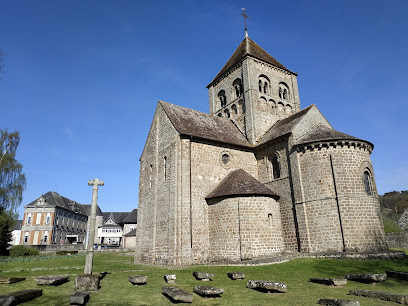
| Description | : | The church Notre-Dame-sur-l'Eau is located at Domfront, in the Orne. Built between the 11th and 12th centuries, it suffered many humiliations. Early listed historical monument, it appears on the list of 1840. The church was named Notre-Dame-sur-l'Eau until the middle of the previous century. The Church was built in the 11th century by the founder of the Château de Domfront, Guillaume I de Bellême. It was a type of the Norman Romanesque architecture. The building underwent many changes over the centuries, especially during the hundred years war. Aerial bombardment reached the nave and the Bell Tower in 1944, without however totally destroy the... Read More |
frequently asked questions (FAQ):
-
Where is L'église Notre-Dame-sur-l'Eau?
L'église Notre-Dame-sur-l'Eau is located at Domfront, Departement de l'Orne ,Basse-Normandie ,France.
-
L'église Notre-Dame-sur-l'Eau cemetery's updated grave count on graveviews.com?
0 memorials
-
Where are the coordinates of the L'église Notre-Dame-sur-l'Eau?
Latitude: 48.5905250
Longitude: -0.6576560
Nearby Cemetories:
1. Cimetière Saint-Front
Domfront, Departement de l'Orne, France
Coordinate: 48.5813140, -0.6251420
2. Cimetiere de Saint Fraimbault
Saint-Fraimbault, Departement de l'Orne, France
Coordinate: 48.4882732, -0.6962598
3. Cimetière de Lignou
Couterne, Departement de l'Orne, France
Coordinate: 48.5239000, -0.4038000
4. Cimetiere de Mortain
Mortain, Departement de la Manche, France
Coordinate: 48.6620873, -0.9288668
5. L'eglise de Notre Dame
Notre-Dame-du-Touchet, Departement de la Manche, France
Coordinate: 48.5904376, -0.9496567
6. Cimeterie de Notre Dame du Touchet
Notre-Dame-du-Touchet, Departement de la Manche, France
Coordinate: 48.5776030, -0.9521320
7. Abbaye de Savigny
Savigny-le-Vieux, Departement de la Manche, France
Coordinate: 48.5019440, -1.0277780
8. Savigny-le-Vieux Abbaye
Savigny-le-Vieux, Departement de la Manche, France
Coordinate: 48.5019440, -1.0277780
9. Chenedolle Churchyard
Chênedollé, Departement du Calvados, France
Coordinate: 48.8548750, -0.7610800
10. Cemetière de Saint Hilaire du Harcouet
Saint-Hilaire-du-Harcouet, Departement de la Manche, France
Coordinate: 48.5770713, -1.0865200
11. Abbaye de Fontaine-Daniel
Saint-Georges-Buttavent, Departement de la Mayenne, France
Coordinate: 48.2777780, -0.6727780
12. La Pellerine Communal Cemetery
La Pellerine, Departement de Maine-et-Loire, France
Coordinate: 48.3154200, -1.0523600
13. Cimetiere de Saint-Thomas-de-Courceriers
Saint-Thomas-de-Courceriers, Departement de la Mayenne, France
Coordinate: 48.2760810, -0.2666760
14. Falaise Communal Cemetery
Falaise, Departement du Calvados, France
Coordinate: 48.8903503, -0.2045760
15. Saint-Martin Churchyard
Beauce, Departement d'Ille-et-Vilaine, France
Coordinate: 48.3333300, -1.1666700
16. Cimetière du Bon Pasteur
Fougères, Departement d'Ille-et-Vilaine, France
Coordinate: 48.3595031, -1.1974079
17. Abbey of St John the Baptist de Falaise
Falaise, Departement du Calvados, France
Coordinate: 48.8947220, -0.1944440
18. Brittany American Cemetery and Memorial
Saint-James, Departement de la Manche, France
Coordinate: 48.5190700, -1.3025000
19. Eglise Saint Thomas (Defunct)
Argentan, Departement de l'Orne, France
Coordinate: 48.7463200, -0.0169700
20. Abbaye Notre-Dame d'Évron
Evron, Departement de la Mayenne, France
Coordinate: 48.1566670, -0.4033330
21. Avranches Communal Cemetery
Avranches, Departement de la Manche, France
Coordinate: 48.6898600, -1.3577600
22. Romagne Communal Cemetery
Romagne, Departement d'Ille-et-Vilaine, France
Coordinate: 48.3445400, -1.2740200
23. St. Jakobus
Zenting, Landkreis Freyung-Grafenau, Germany
Coordinate: 48.7910627, 0.0000000
24. Église Saint-Laurent
Saint-Lô, Departement de la Manche, France
Coordinate: 48.9580432, -1.1425624

