
| Memorials | : | 0 |
| Location | : | Mishawaka, St. Joseph County, USA |
| Coordinate | : | 41.6630210, -86.1371720 |
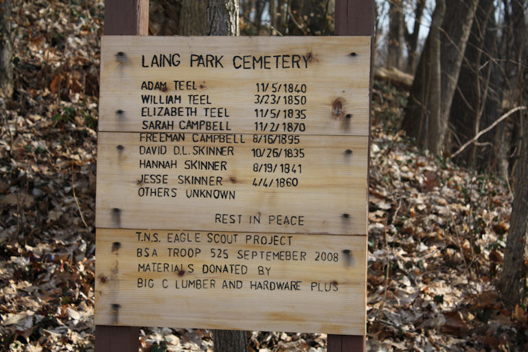
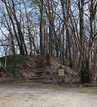
| Description | : | Laing Park Cemetery has had several names, Skinner Family or Teel Family Cemetery and also known as Twin Branch Cemetery, was located in what is now Laing Park at 2749 Lincoln Way East in Mishawaka, IN. The exact location cannot be identified, it was probably 350-380 feet south of the highway on top of the hill on the east end of the park. In 1831 the property was deeded to Jesse Skinner by the US government. Sep 9, 1836-Alanson and Sarah Hurd to Jesse Skinner 6.03 acres. Hurd was the owner of the Iron Ore Mine and foundry there. Dec 30,... Read More |
frequently asked questions (FAQ):
-
Where is Laing Park Cemetery?
Laing Park Cemetery is located at 2749 Lincoln Way East Mishawaka, St. Joseph County ,Indiana , 46544USA.
-
Laing Park Cemetery cemetery's updated grave count on graveviews.com?
0 memorials
-
Where are the coordinates of the Laing Park Cemetery?
Latitude: 41.6630210
Longitude: -86.1371720
Nearby Cemetories:
1. Eutzler Cemetery
Mishawaka, St. Joseph County, USA
Coordinate: 41.6335983, -86.1430969
2. Byrkit Cemetery
Osceola, St. Joseph County, USA
Coordinate: 41.6740112, -86.0994415
3. Mishawaka City Cemetery
Mishawaka, St. Joseph County, USA
Coordinate: 41.6723824, -86.1837234
4. Fairview Cemetery
Mishawaka, St. Joseph County, USA
Coordinate: 41.6747017, -86.1830978
5. Saint Joseph Catholic Cemetery
Mishawaka, St. Joseph County, USA
Coordinate: 41.6725006, -86.1860962
6. Smith Cemetery
Penn Township, St. Joseph County, USA
Coordinate: 41.6432910, -86.1844040
7. Hebrew Orthodox Cemetery
Mishawaka, St. Joseph County, USA
Coordinate: 41.6721840, -86.1963882
8. Pleasant Valley Cemetery
Mishawaka, St. Joseph County, USA
Coordinate: 41.6810989, -86.0808029
9. Chapel Hill Memorial Gardens
Osceola, St. Joseph County, USA
Coordinate: 41.6789017, -86.0792007
10. Sisters of Saint Francis Convent Cemetery
Mishawaka, St. Joseph County, USA
Coordinate: 41.6419300, -86.1962600
11. Osceola Cemetery
Elkhart, Elkhart County, USA
Coordinate: 41.6631813, -86.0602951
12. Ferrisville Cemetery
Penn Township, St. Joseph County, USA
Coordinate: 41.6080220, -86.1774020
13. Saint Joseph Valley Memorial Park
Mishawaka, St. Joseph County, USA
Coordinate: 41.7217445, -86.1831512
14. Rose Hill Cemetery
South Bend, St. Joseph County, USA
Coordinate: 41.6575890, -86.2348404
15. Bowman Cemetery
South Bend, St. Joseph County, USA
Coordinate: 41.6567993, -86.2348099
16. Noffsinger Cemetery
Elkhart County, USA
Coordinate: 41.6362300, -86.0416170
17. Saint Michael and All Angels Church Memorial Garde
South Bend, St. Joseph County, USA
Coordinate: 41.7129530, -86.2158230
18. Zion United Church of Christ Cremation Garden
South Bend, St. Joseph County, USA
Coordinate: 41.6740640, -86.2401870
19. Christ the King Lutheran Church Columbarium
South Bend, St. Joseph County, USA
Coordinate: 41.7240810, -86.2017250
20. California Road Church Cemetery
Elkhart, Elkhart County, USA
Coordinate: 41.6951408, -86.0372314
21. Old Jewish Cemetery (Defunct)
South Bend, St. Joseph County, USA
Coordinate: 41.6826310, -86.2447640
22. Cedar Grove Cemetery
Notre Dame, St. Joseph County, USA
Coordinate: 41.6944008, -86.2406006
23. Rohrer Cemetery
St. Joseph County, USA
Coordinate: 41.6290588, -86.2406387
24. Basilica of The Sacred Heart
Notre Dame, St. Joseph County, USA
Coordinate: 41.7022860, -86.2397000