
| Memorials | : | 1 |
| Location | : | Fulton County, USA |
| Coordinate | : | 40.5674200, -90.1124000 |
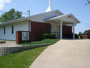
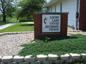
| Description | : | The cemetery is located in Joshua Township about 800 feet west of County Road 19 behind the Locust Lane United Methodist Church. The U.S. Geological Survey (USGS) Geographic Names Information System (GNIS) feature ID for the cemetery is 1773346 (Locust Lane Cemetery / Grove Union Lutheran Graveyard / Providence Cemetery). |
frequently asked questions (FAQ):
-
Where is Locust Lane United Methodist Church Cemetery?
Locust Lane United Methodist Church Cemetery is located at County Road 19 Fulton County ,Illinois , 61520USA.
-
Locust Lane United Methodist Church Cemetery cemetery's updated grave count on graveviews.com?
0 memorials
-
Where are the coordinates of the Locust Lane United Methodist Church Cemetery?
Latitude: 40.5674200
Longitude: -90.1124000

Nearby Cemetories:
1. Gardiner Cemetery
Fulton County, USA
Coordinate: 40.5600014, -90.1222000
2. Moore Cemetery
Canton, Fulton County, USA
Coordinate: 40.5604700, -90.1230920
3. Thompson Cemetery
Fulton County, USA
Coordinate: 40.5280991, -90.1241989
4. Shields Chapel Cemetery
Canton, Fulton County, USA
Coordinate: 40.5240800, -90.0867700
5. Saint Marys Cemetery
Canton, Fulton County, USA
Coordinate: 40.5471992, -90.0385971
6. Johnson Cemetery
Fulton County, USA
Coordinate: 40.5966988, -90.0421982
7. Greenwood Cemetery
Canton, Fulton County, USA
Coordinate: 40.5457993, -90.0369034
8. Saint Joseph Cemetery
Canton, Fulton County, USA
Coordinate: 40.5433006, -90.0369034
9. Bybee Station Cemetery
Fulton County, USA
Coordinate: 40.5969009, -90.1936035
10. Foster Cemetery
Fairview, Fulton County, USA
Coordinate: 40.6405983, -90.1324997
11. Saunders-Blackaby Cemetery
Bryant, Fulton County, USA
Coordinate: 40.4911003, -90.1256027
12. Fiatt Cemetery
Fiatt, Fulton County, USA
Coordinate: 40.5518990, -90.2146988
13. Fairview Cemetery
Fairview, Fulton County, USA
Coordinate: 40.6355800, -90.1686100
14. Coal Creek Dunkard Cemetery
Farmington, Fulton County, USA
Coordinate: 40.6469002, -90.0738983
15. White Chapel Memory Gardens
Canton, Fulton County, USA
Coordinate: 40.5480995, -90.0018997
16. Providence Chapel Church Cemetery
Farmington, Fulton County, USA
Coordinate: 40.6553500, -90.1007700
17. Norris Cemetery
Norris, Fulton County, USA
Coordinate: 40.6251170, -90.0240110
18. Hanson Cemetery
Canton, Fulton County, USA
Coordinate: 40.6260880, -90.0237010
19. Zion Cemetery
Fulton County, USA
Coordinate: 40.5886002, -90.2277985
20. High Bridge Cemetery
Dunfermline, Fulton County, USA
Coordinate: 40.4949989, -90.0286026
21. Hill Cemetery
Fulton County, USA
Coordinate: 40.6422005, -90.0307999
22. Markley Cemetery
Fairview, Fulton County, USA
Coordinate: 40.6316986, -90.2121964
23. Beer Cemetery
Fulton County, USA
Coordinate: 40.6319008, -90.2174988
24. Cuba Cemetery
Cuba, Fulton County, USA
Coordinate: 40.4875600, -90.1972800