
| Memorials | : | 0 |
| Location | : | Fosterville, York County, Canada |
| Coordinate | : | 45.8008300, -67.7613900 |
| Description | : | Fosterville is a Canadian rural community located in western York County, New Brunswick. Situated on the International Boundary in the parish of North Lake, Fosterville has a small population but is popular in the summer months with cottage owners from the state of Maine and surrounding areas in New Brunswick. The community was home to a school up until the late 1980s when it was closed by the New Brunswick Department of Education. The building was taken over by the community and turned into a community centre. In 2004 the building was removed and replaced with a new, modern structure to meet... Read More |
frequently asked questions (FAQ):
-
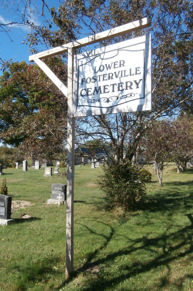
Where is Lower Fosterville Cemetery?
Lower Fosterville Cemetery is located at Rte. 122-North Lake Parish Fosterville, York County ,New Brunswick ,Canada.
-
Lower Fosterville Cemetery cemetery's updated grave count on graveviews.com?
0 memorials
-
Where are the coordinates of the Lower Fosterville Cemetery?
Latitude: 45.8008300
Longitude: -67.7613900
Nearby Cemetories:
1. Upper Fosterville Cemetery
Fosterville, York County, Canada
Coordinate: 45.8077200, -67.7696100
2. Orient Cemetery
Orient, Aroostook County, USA
Coordinate: 45.8017640, -67.8204540
3. Maxwell Cemetery
Maxwell, York County, Canada
Coordinate: 45.8909570, -67.6937740
4. South Amity Cemetery
South Amity, Aroostook County, USA
Coordinate: 45.8837550, -67.8507920
5. Chapman Cemetery
Maxwell, York County, Canada
Coordinate: 45.9026000, -67.6909100
6. Butterfield Burial Ground
Aroostook County, USA
Coordinate: 45.7091670, -67.8608330
7. Estabrook Cemetery
North Amity, Aroostook County, USA
Coordinate: 45.9075012, -67.8811035
8. Tuck Cemetery
Haynesville, Aroostook County, USA
Coordinate: 45.8072680, -67.9693760
9. Trout Brook Cemetery
Aroostook County, USA
Coordinate: 45.6949997, -67.9047012
10. Amity Cemetery
North Amity, Aroostook County, USA
Coordinate: 45.9430730, -67.8297200
11. Riverside Cemetery
Haynesville, Aroostook County, USA
Coordinate: 45.8181000, -67.9828033
12. Hilltop Cemetery
Danforth, Washington County, USA
Coordinate: 45.6613998, -67.8735962
13. Wilson Cemetery
Haynesville, Aroostook County, USA
Coordinate: 45.8357000, -67.9865000
14. St. David's Presbyterian Cemetery
Kirkland, Carleton County, Canada
Coordinate: 45.9684230, -67.7149480
15. Saint Monica Roman Catholic Cemetery
Cary, Aroostook County, USA
Coordinate: 45.9653320, -67.8417890
16. Beans Falls Cemetery
Bancroft, Aroostook County, USA
Coordinate: 45.7201380, -67.9823410
17. Hartin Settlement Cemetery
Hartin Settlement, York County, Canada
Coordinate: 45.8990400, -67.5487400
18. St. Paul's Anglican Cemetery
Kirkland, Carleton County, Canada
Coordinate: 45.9979750, -67.7267240
19. Eaton Cemetery
Eaton, Washington County, USA
Coordinate: 45.5988998, -67.8043976
20. Skiff Lake Cemetery
Skiff Lake, York County, Canada
Coordinate: 45.8976500, -67.4928800
21. Marne Cemetery
Marne, York County, Canada
Coordinate: 45.8978000, -67.4928300
22. Village Lighthouse Pentecostal Cemetery
Benton, Carleton County, Canada
Coordinate: 45.9823540, -67.6040010
23. Benton Anglican Cemetery
Benton, Carleton County, Canada
Coordinate: 45.9893540, -67.6056850
24. Benton Community Cemetery
Benton, Carleton County, Canada
Coordinate: 45.9901600, -67.6060900