
| Memorials | : | 0 |
| Location | : | Jackson County, USA |
| Coordinate | : | 34.0580170, -83.6650670 |
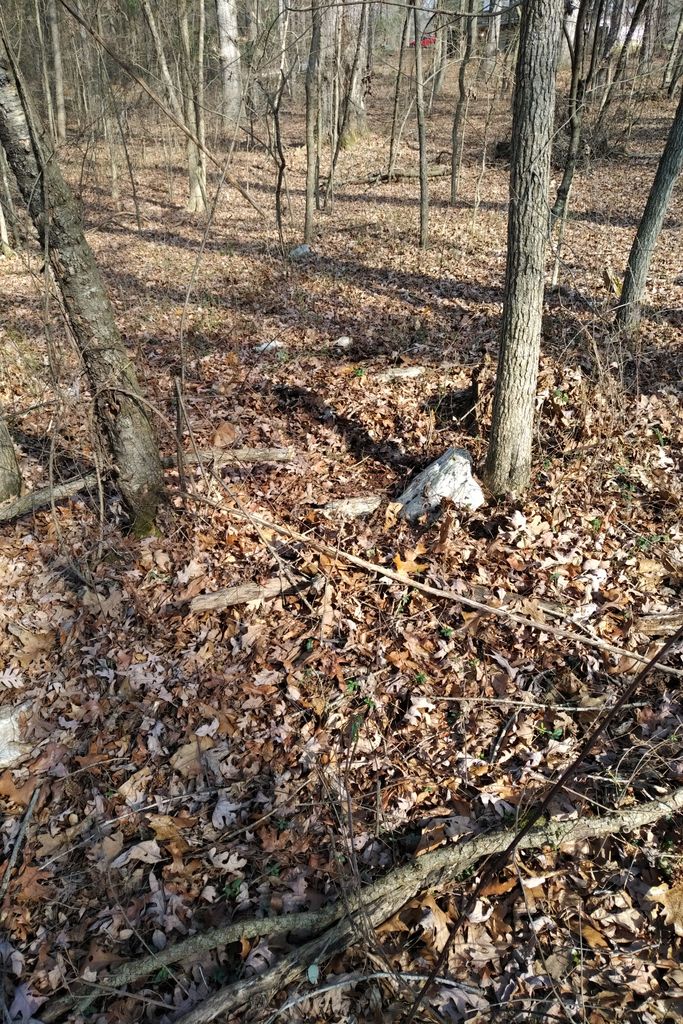
| Description | : | This burial ground/cemetery is on private property. Currently owned by the Hays family. It was owned by the Horton family back in the 1800s when these graves were likely created. There are several graves here but only 1 is marked with a legible marker. The rest are just depressions in the ground and/or rocks and stones. There appear to be about 6-8 graves. Lacking any other information, I am calling this the Mary Ann Mitchell Cemetery due to not having any further information on the others buried here . I found this on 1/30/2020 with the help of the... Read More |
frequently asked questions (FAQ):
-
Where is Mary Ann Mitchell Cemetery?
Mary Ann Mitchell Cemetery is located at Near Highway 11 and Gum Springs Church Road Jackson County ,Georgia ,USA.
-
Mary Ann Mitchell Cemetery cemetery's updated grave count on graveviews.com?
0 memorials
-
Where are the coordinates of the Mary Ann Mitchell Cemetery?
Latitude: 34.0580170
Longitude: -83.6650670
Nearby Cemetories:
1. O'Shields Cemetery
Auburn, Barrow County, USA
Coordinate: 34.0411490, -83.6628760
2. Oak Grove Cemetery
Jackson County, USA
Coordinate: 34.0705986, -83.6813965
3. Charles Allen Cemetery
Jackson County, USA
Coordinate: 34.0772400, -83.6664200
4. Ebenezer Cemetery
Jefferson, Jackson County, USA
Coordinate: 34.0593987, -83.6399994
5. Justice Family Cemetery
Hoschton, Jackson County, USA
Coordinate: 34.0672940, -83.6918760
6. Gum Springs Cemetery
Jackson County, USA
Coordinate: 34.0802250, -83.6836950
7. Johnson Family Cemetery
Winder, Barrow County, USA
Coordinate: 34.0432790, -83.6364440
8. Daniel U. Wood Cemetery
Hoschton, Jackson County, USA
Coordinate: 34.0826000, -83.6848000
9. Union Baptist Church Cemetery
Winder, Barrow County, USA
Coordinate: 34.0282640, -83.6767670
10. Maddox Family Cemetery
Winder, Barrow County, USA
Coordinate: 34.0279840, -83.6762090
11. Geiger Cemetery
Jefferson, Jackson County, USA
Coordinate: 34.0653853, -83.6255568
12. Segars Family Cemetery
Winder, Barrow County, USA
Coordinate: 34.0191390, -83.6687750
13. Lyle Cemetery
Jackson County, USA
Coordinate: 34.0581240, -83.7130310
14. William E Hill Family Cemetery
Barrow County, USA
Coordinate: 34.0342430, -83.7035010
15. Ross-Haynie-Finch Family Cemetery
Winder, Barrow County, USA
Coordinate: 34.0403850, -83.6202940
16. McElhannon Family Cemetery
Winder, Barrow County, USA
Coordinate: 34.0315330, -83.6267940
17. White Plains Cemetery
Jefferson, Jackson County, USA
Coordinate: 34.0997009, -83.6682968
18. Cedar Grove Independent Methodist Church Cemetery
Jefferson, Jackson County, USA
Coordinate: 34.0589980, -83.6137760
19. New Pentecost United Methodist Church Cemetery
Winder, Barrow County, USA
Coordinate: 34.0163950, -83.6437740
20. Allen Family Cemetery
Hoschton, Jackson County, USA
Coordinate: 34.0798790, -83.7133390
21. Wood Family Cemetery
Barrow County, USA
Coordinate: 34.0250015, -83.6267014
22. Delaperriere Cemetery
Jefferson, Jackson County, USA
Coordinate: 34.0977340, -83.6933490
23. Center United Methodist Church Cemetery
Hoschton, Jackson County, USA
Coordinate: 34.0803160, -83.7138900
24. Rockwell Universalist Church Cemetery
Mulberry, Barrow County, USA
Coordinate: 34.0354440, -83.7137500