
| Memorials | : | 36 |
| Location | : | Ekalaka, Carter County, USA |
| Coordinate | : | 46.0545460, -104.4554010 |
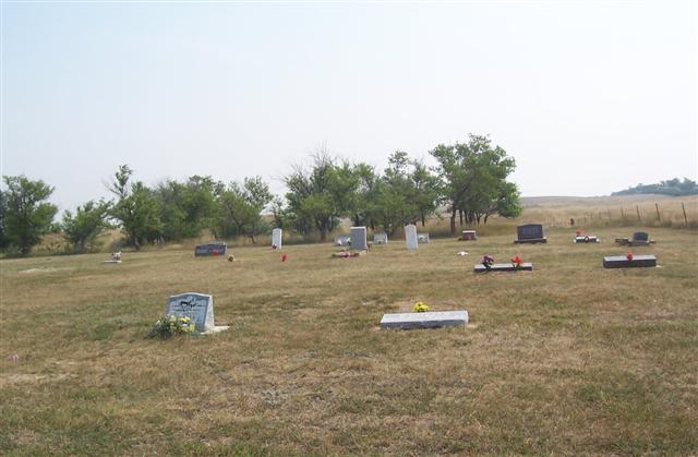
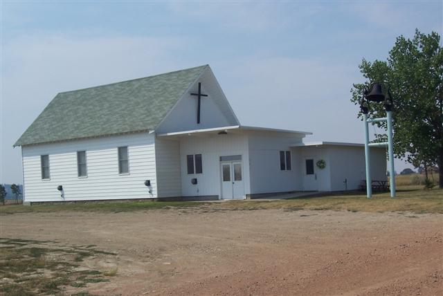
| Description | : | Medicine Rock Church Cemetery is located about 12 1/2 miles north of Ekalaka on the Carter County and Fallon County line next to the Medicine Rock Church. It is also on the north boundry of the Medicine Rock State Park. |
frequently asked questions (FAQ):
-
Where is Medicine Rock Church Cemetery?
Medicine Rock Church Cemetery is located at Ekalaka, Carter County ,Montana ,USA.
-
Medicine Rock Church Cemetery cemetery's updated grave count on graveviews.com?
36 memorials
-
Where are the coordinates of the Medicine Rock Church Cemetery?
Latitude: 46.0545460
Longitude: -104.4554010
Nearby Cemetories:
1. Willard Cemetery
Willard, Fallon County, USA
Coordinate: 46.1932000, -104.4123460
2. Beaver Lodge Cemetery
Ekalaka, Carter County, USA
Coordinate: 45.8847008, -104.5522003
3. Lame Jones Cemetery
Plevna, Fallon County, USA
Coordinate: 46.2230988, -104.6181030
4. Russell Cemetery
Carter County, USA
Coordinate: 45.8292007, -104.4681015
5. Saint John Cemetery
Baker, Fallon County, USA
Coordinate: 46.3563995, -104.2822037
6. Askin Family Cemetery
Fallon County, USA
Coordinate: 46.3806000, -104.2811000
7. Bonnievale Cemetery
Baker, Fallon County, USA
Coordinate: 46.3819008, -104.2791977
8. Saint Anthony Cemetery
Plevna, Fallon County, USA
Coordinate: 46.4042015, -104.5199966
9. Peace Lutheran Cemetery
Plevna, Fallon County, USA
Coordinate: 46.4169006, -104.5294037
10. Trenk Family Plot
Ekalaka, Carter County, USA
Coordinate: 45.7325000, -104.7083333
11. Community Union Cemetery
Plevna, Fallon County, USA
Coordinate: 46.4180984, -104.5289001
12. Fertile Prairie Cemetery
Fallon County, USA
Coordinate: 46.3396988, -104.0935974
13. Evangelical Lutheran Friedendal Cemetery
Prairie County, USA
Coordinate: 46.4632300, -104.4778500
14. Friedens Congregational Cemetery
Prairie County, USA
Coordinate: 46.4632800, -104.4779600
15. Brost Cemetery
Prairie County, USA
Coordinate: 46.4649880, -104.5280000
16. Westmore Cemetery
Westmore, Fallon County, USA
Coordinate: 46.4720000, -104.6358000
17. Riverside Cemetery
Marmarth, Slope County, USA
Coordinate: 46.2942009, -103.9067001
18. MacKenzie Family Cemetery
Custer County, USA
Coordinate: 46.1569500, -105.1448000
19. Knowlton Cemetery
Custer County, USA
Coordinate: 46.3210983, -105.0710983
20. Ismay Cemetery
Ismay, Custer County, USA
Coordinate: 46.4982986, -104.8133011
21. Pioneer Cemetery
Carter County, USA
Coordinate: 45.5859560, -104.1484850
22. Cottonwood Cemetery
Custer County, USA
Coordinate: 46.4294014, -104.9674988
23. Fort Dilts Cemetery
Rhame, Bowman County, USA
Coordinate: 46.2793130, -103.7763900
24. Ladner Cemetery
Ladner, Harding County, USA
Coordinate: 45.8238983, -103.7694016