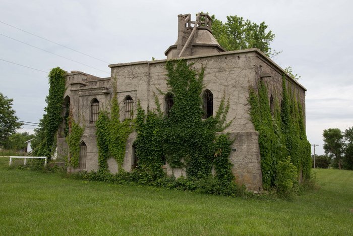
| Memorials | : | 0 |
| Location | : | Holden, Johnson County, USA |
| Coordinate | : | 38.7302885, -93.9929970 |
| Description | : | The mausoleum was built by Joseph M. Miller, a prominent citizen of Madison Township in Johnson County, Missouri. He was a teacher, a farmer, and a man who liked to read the Bible. He decided he didn't want to be buried because of his concern about the water that settles into graves. He appreciated the ideas of people in the Bible burying their dead in caves where they would be dry. He began working on the mausoleum in 1916 and it became known as "Joseph's Tomb". It's not clear exactly when the main structure was finished but in 1934 the... Read More |
frequently asked questions (FAQ):
-
Where is Miller Mausoleum?
Miller Mausoleum is located at Holden, Johnson County ,Missouri ,USA.
-
Miller Mausoleum cemetery's updated grave count on graveviews.com?
0 memorials
-
Where are the coordinates of the Miller Mausoleum?
Latitude: 38.7302885
Longitude: -93.9929970
Nearby Cemetories:
1. Fairview Cemetery
Holden, Johnson County, USA
Coordinate: 38.7324982, -93.9918976
2. Holden Cemetery
Holden, Johnson County, USA
Coordinate: 38.7127991, -94.0066986
3. Saint Patrick Cemetery
Holden, Johnson County, USA
Coordinate: 38.7106018, -93.9749985
4. Mount Calvary Catholic Cemetery
Holden, Johnson County, USA
Coordinate: 38.7102400, -93.9753100
5. Ferguson Cemetery
Holden, Johnson County, USA
Coordinate: 38.7433014, -93.9618988
6. Rock Springs Cemetery
Holden, Johnson County, USA
Coordinate: 38.7754517, -93.9978867
7. Kingsville Cemetery
Kingsville, Johnson County, USA
Coordinate: 38.7472191, -94.0667725
8. Medford Cemetery
Holden, Johnson County, USA
Coordinate: 38.6595001, -94.0061035
9. Medford Cemetery
Johnson County, USA
Coordinate: 38.6594009, -94.0057983
10. Gilbert Cemetery
Kingsville, Johnson County, USA
Coordinate: 38.6842003, -94.0686035
11. Stout Cemetery
Kingsville, Johnson County, USA
Coordinate: 38.6694946, -94.0529099
12. Bluff Springs Cemetery
Kingsville, Johnson County, USA
Coordinate: 38.7703018, -94.0768967
13. Haymaker Cemetery
Johnson County, USA
Coordinate: 38.7578011, -93.9008026
14. Duncan Cemetery
Johnson County, USA
Coordinate: 38.7141991, -94.0942001
15. Wesley Chapel Cemetery
Kingsville, Johnson County, USA
Coordinate: 38.8011300, -94.0466200
16. Wesley Chapel Cemetery
Kingsville, Johnson County, USA
Coordinate: 38.8011470, -94.0465880
17. Elliott Cemetery
Centerview, Johnson County, USA
Coordinate: 38.6991997, -93.8846970
18. Saint John Cemetery
Holden, Johnson County, USA
Coordinate: 38.8037500, -93.9163700
19. Outon Cemetery
Johnson County, USA
Coordinate: 38.6363983, -93.9567032
20. Hornsby Cemetery
Kingsville, Johnson County, USA
Coordinate: 38.6996994, -94.1168976
21. Slate Cemetery
Centerview Township, Johnson County, USA
Coordinate: 38.7223846, -93.8625766
22. Blackwater Cemetery
Holden, Johnson County, USA
Coordinate: 38.8282900, -93.9533500
23. Dix Cemetery
Centerview, Johnson County, USA
Coordinate: 38.7578011, -93.8589020
24. Bear Creek Cemetery
Holden, Johnson County, USA
Coordinate: 38.6220600, -93.9681800


