
| Memorials | : | 0 |
| Location | : | Snead, Blount County, USA |
| Coordinate | : | 34.1200470, -86.3508010 |
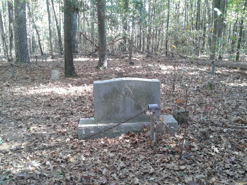
| Description | : | Located in a "Pine Thicket" on the Tommy Snead Farm A military marker and a family memorial along with a few scattered unreadable sandstones is all that is left of this cemetery. This cemetery has been documented entirely and all graves have been photographed. Grave dowsing done in fall of 2012 showed 200+ graves completely unmarked. All the trees in a large radius are very small in diameter suggesting the same conclusion that this area was open such as a cemetery. Bldg foundations were also located by professional dowsing experts suggesting a church may have been on... Read More |
frequently asked questions (FAQ):
-
Where is Miller Pine Thicket Cemetery?
Miller Pine Thicket Cemetery is located at Snead, Blount County ,Alabama ,USA.
-
Miller Pine Thicket Cemetery cemetery's updated grave count on graveviews.com?
0 memorials
-
Where are the coordinates of the Miller Pine Thicket Cemetery?
Latitude: 34.1200470
Longitude: -86.3508010
Nearby Cemetories:
1. Union Grove Cemetery #2
Snead, Blount County, USA
Coordinate: 34.1346270, -86.3426870
2. Cook Gravesite
Highmound, Blount County, USA
Coordinate: 34.1422340, -86.3549700
3. Antioch Church of Christ Cemetery
Snead, Blount County, USA
Coordinate: 34.1094420, -86.3760140
4. Mount Carmel Cemetery
Snead, Blount County, USA
Coordinate: 34.1068993, -86.3253021
5. Bethel Church Cemetery
Snead, Blount County, USA
Coordinate: 34.1130562, -86.3836136
6. New Emmaus Cemetery
Wynnville, Blount County, USA
Coordinate: 34.0854240, -86.3500810
7. Highmound Baptist Church Cemetery
Snead, Blount County, USA
Coordinate: 34.1473370, -86.3807800
8. New Clear Creek Cemetery
Marshall County, USA
Coordinate: 34.1511002, -86.3142014
9. Mount Hebron Missionary Baptist Church Cemetery
Douglas, Marshall County, USA
Coordinate: 34.1366997, -86.3005981
10. Holland Cemetery
Blount County, USA
Coordinate: 34.1610985, -86.3783035
11. Zion Hill Primitive Baptist Church Cemetery
Snead, Blount County, USA
Coordinate: 34.1655998, -86.3700027
12. Byrd Cemetery
Blount County, USA
Coordinate: 34.0702220, -86.3292570
13. Wynnville Cemetery
Wynnville, Blount County, USA
Coordinate: 34.0807991, -86.3945007
14. Ebenezer Methodist Cemetery
Snead, Blount County, USA
Coordinate: 34.1009270, -86.4111240
15. Concord Missionary Baptist Church Cemetery
Douglas, Marshall County, USA
Coordinate: 34.1740300, -86.3551800
16. Douglas Cemetery
Douglas, Marshall County, USA
Coordinate: 34.1721992, -86.3264008
17. Mount Zion Church of God Cemetery
Snead, Blount County, USA
Coordinate: 34.0933290, -86.4119950
18. Old Clear Creek Cemetery
Marshall County, USA
Coordinate: 34.1467018, -86.2874985
19. Pleasant Grove Cemetery
Snead, Blount County, USA
Coordinate: 34.1683006, -86.3930969
20. Lamb Cemetery
Blount County, USA
Coordinate: 34.0861015, -86.4158020
21. Friendship Baptist Church Cemetery
Boaz, Marshall County, USA
Coordinate: 34.1519012, -86.2822037
22. Harmony Missionary Baptist Church Cemetery
Ellison Crossroads, Blount County, USA
Coordinate: 34.0535126, -86.3527145
23. Bethlehem Cemetery
Douglas, Marshall County, USA
Coordinate: 34.1866880, -86.3346590
24. Cornelius Cemetery
Walnut Grove, Etowah County, USA
Coordinate: 34.0657997, -86.2983017