
| Memorials | : | 0 |
| Location | : | Mo, Surnadal kommune, Norway |
| Coordinate | : | 62.9999600, 8.9677600 |
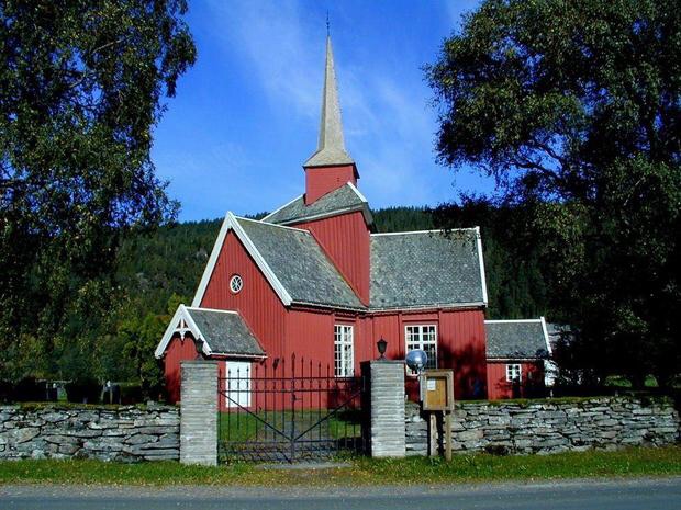
| Description | : | Mo church Mo Church was built by Master Builder Erik Holten from Bæverdalen in 1728 using cog jointed, round timber. The main level is Y-shaped with an equilateral triangle in the middle and a square on each side. Ten Y-shaped churches was buit in Norway during the period 1663-1753, but several more may have been built. Both in the structure and idea, Y-shaped churches represented a unique and distinctly Norwegian architectural style. Five of the T-shaped churses are still in use: Rennebu Church (1669), Holmestrand Church (1674), Tydal Church (1696), Mo Church (1728) and Budal Church (1753). The other five... Read More |
frequently asked questions (FAQ):
-
Where is Mo Church and Cemetery?
Mo Church and Cemetery is located at Mo, Surnadal kommune ,Møre og Romsdal fylke ,Norway.
-
Mo Church and Cemetery cemetery's updated grave count on graveviews.com?
0 memorials
-
Where are the coordinates of the Mo Church and Cemetery?
Latitude: 62.9999600
Longitude: 8.9677600
Nearby Cemetories:
1. Ranes Church Cemetery
Surnadalsora, Surnadal kommune, Norway
Coordinate: 62.9760900, 8.7719900
2. Øye Church and Cemetery
Surnadalsora, Surnadal kommune, Norway
Coordinate: 62.9806500, 8.7186400
3. Rindal Kirke
Rindal, Rindal kommune, Norway
Coordinate: 63.0516900, 9.2097600
4. Øvre Rindal Cemetery
Rindal, Rindal kommune, Norway
Coordinate: 63.0977240, 9.3222820
5. Vinje Cemetery
Hemne kommune, Norway
Coordinate: 63.2069160, 8.9976275
6. Åsskard Church Cemetery
Asskard, Surnadal kommune, Norway
Coordinate: 63.0179490, 8.4965090
7. Stangvik Church and Cemetery
Stangvik, Surnadal kommune, Norway
Coordinate: 62.9170200, 8.4592500
8. Otnes Cemetery
Halsa kommune, Norway
Coordinate: 63.1378169, 8.4908078
9. Kyrksaeterora
Kyrksaeterora, Hemne kommune, Norway
Coordinate: 63.2871945, 9.0793049
10. Hemne Cemetery
Kyrksaeterora, Hemne kommune, Norway
Coordinate: 63.2873839, 9.0795139
11. Taknes Bay Shoreline
Halsa kommune, Norway
Coordinate: 63.1455110, 8.3328090
12. Torjulvågen
Torjul, Tingvoll kommune, Norway
Coordinate: 62.9730714, 8.2505570
13. Aure Cemetery
Aure, Aure kommune, Norway
Coordinate: 63.2657700, 8.5281369
14. Halsa
Halsa, Halsa kommune, Norway
Coordinate: 63.0755500, 8.2459500
15. Meldal Cemetery
Meldal, Meldal kommune, Norway
Coordinate: 63.0457620, 9.7168730
16. Løkken Kirkegaard
Lokken Verk, Meldal kommune, Norway
Coordinate: 63.1266380, 9.6842770
17. Nerskogen
Nerskogen, Rennebu kommune, Norway
Coordinate: 62.7880661, 9.6229760
18. Tingvoll Church Cemetery
Tingvoll, Tingvoll kommune, Norway
Coordinate: 62.9123766, 8.1816537
19. Loykja Cemetery
Sunndalsora, Sunndal kommune, Norway
Coordinate: 62.6439840, 8.7299540
20. Øksendal Cemetery
Oksendalsora, Sunndal kommune, Norway
Coordinate: 62.7166020, 8.4310220
21. Øksendal Old Cemetery
Oksendalsora, Sunndal kommune, Norway
Coordinate: 62.7139050, 8.4293530
22. Romfo Kirke Cemetery
Gjora, Sunndal kommune, Norway
Coordinate: 62.6024070, 8.9386060
23. Moe
Orkanger, Orkdal kommune, Norway
Coordinate: 63.1877130, 9.7653600
24. Rennebu Cemetery
Rennebu kommune, Norway
Coordinate: 62.8754490, 9.8329060