
| Memorials | : | 0 |
| Location | : | Lincoln, Washington County, USA |
| Coordinate | : | 35.9380360, -94.4050880 |
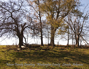
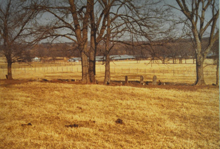
| Description | : | Moore Family Cemetery Located near Lincoln, East off HWY 62 Approximately 1 mile. On the old road to Cane Hill, On the old Moore place. Now the Williams Farm. Moore's Creek flows through the area and runs into Lincoln Lake. See map below for directions. UPDATE: we are so thankful that the Washington County cemetery Preservation Group has been helping keep our cemetery In good shape. Thanks to Alvin Derby and the group of workers that have volunteered their time to restore all cemeteries in Washington county. They do great things for our loved ones . Please make donations to the... Read More |
frequently asked questions (FAQ):
-
Where is Moore Family Cemetery?
Moore Family Cemetery is located at Old Cane Hill Road, Williams Farm Lincoln, Washington County ,Arkansas , 72744USA.
-
Moore Family Cemetery cemetery's updated grave count on graveviews.com?
0 memorials
-
Where are the coordinates of the Moore Family Cemetery?
Latitude: 35.9380360
Longitude: -94.4050880
Nearby Cemetories:
1. Cheatham Cemetery
Lincoln, Washington County, USA
Coordinate: 35.9508018, -94.4075012
2. Carnahan Cemetery
Canehill, Washington County, USA
Coordinate: 35.9251150, -94.4059980
3. Bean Cemetery
Lincoln, Washington County, USA
Coordinate: 35.9486008, -94.4169006
4. Canehill Cemetery
Canehill, Washington County, USA
Coordinate: 35.9142300, -94.3996600
5. Hargrove Cemetery
Washington County, USA
Coordinate: 35.9443810, -94.4339540
6. Lincoln Cemetery
Lincoln, Washington County, USA
Coordinate: 35.9561110, -94.4255920
7. Parks Corner Cemetery
Canehill, Washington County, USA
Coordinate: 35.9461900, -94.3732000
8. Pyeatt Cemetery
Canehill, Washington County, USA
Coordinate: 35.9200660, -94.4321470
9. McClellan Cemetery
Canehill, Washington County, USA
Coordinate: 35.9014015, -94.4060974
10. Mitchell Cemetery
Prairie Grove, Washington County, USA
Coordinate: 35.9173980, -94.3675800
11. Kidd Cemetery
Canehill, Washington County, USA
Coordinate: 35.9003650, -94.4043500
12. Russell Cemetery
Washington County, USA
Coordinate: 35.8911018, -94.4182968
13. Drake Cemetery
Washington County, USA
Coordinate: 35.8978004, -94.4488983
14. Sugar Hill Cemetery
Lincoln, Washington County, USA
Coordinate: 35.9213982, -94.4685974
15. New Hope Cemetery
Washington County, USA
Coordinate: 35.9019012, -94.3491974
16. Beaty Cemetery
Lincoln, Washington County, USA
Coordinate: 35.9852730, -94.4528420
17. Reese Cemetery
Clyde, Washington County, USA
Coordinate: 35.8782997, -94.3827972
18. Pleasant Home Cemetery
Prairie Grove, Washington County, USA
Coordinate: 35.9276500, -94.3283600
19. William Wilson Family Cemetery
Washington County, USA
Coordinate: 35.9959790, -94.3742830
20. Bethesda Cemetery
Morrow, Washington County, USA
Coordinate: 35.8782997, -94.4535980
21. Cox Cemetery
Morrow, Washington County, USA
Coordinate: 35.8657990, -94.3989029
22. Summers Cemetery
Summers, Washington County, USA
Coordinate: 35.9751020, -94.4828160
23. Rheas Mill Cemetery
Rhea, Washington County, USA
Coordinate: 36.0157010, -94.4067990
24. Edmiston Cemetery
Morrow, Washington County, USA
Coordinate: 35.8605995, -94.4235992