
| Memorials | : | 0 |
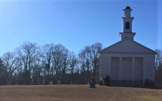
| Location | : | Sardis, Dallas County, USA |
| Coordinate | : | 32.1648500, -86.9081820 |
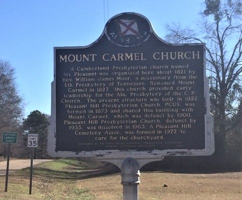
| Description | : | There is a historic marker out front that reads, "A Cumberland Presbyterian church named Mt. Pleasant was organized here about 1821 by Rev William James Moor, a missionary from the Elk Presbyterian of Tennessee. Renamed Mount Carmel in 1827, this church provided early leadership for the Ala. Presbytery of the C.P. Church. The present structure was built in 1852. Pleasant Hill Presbyterian Church, PCUS was formed in 1873 and shared this building with Mount Carmel which was defunct by 1900. Pleasant Hill Presbyterian Church, defunct by 1935, was dissolved in 1963. A Pleasant Hill Cemetery... Read More |
frequently asked questions (FAQ):
-
Where is Mount Carmel Church Cemetery?
Mount Carmel Church Cemetery is located at County Road 12 Sardis, Dallas County ,Alabama , 36775USA.
-
Mount Carmel Church Cemetery cemetery's updated grave count on graveviews.com?
0 memorials
-
Where are the coordinates of the Mount Carmel Church Cemetery?
Latitude: 32.1648500
Longitude: -86.9081820
Nearby Cemetories:
1. Pleasant Hill Cumberland Presbyterian Church Cemet
Pleasant Hill, Dallas County, USA
Coordinate: 32.1649780, -86.9081650
2. Pleasant Hill Baptist Church Cemetery
Sardis, Dallas County, USA
Coordinate: 32.1668670, -86.9083090
3. Underwood Cemetery
Dallas County, USA
Coordinate: 32.1671982, -86.9255981
4. Mount Lebanon Cemetery
Pleasant Hill, Dallas County, USA
Coordinate: 32.1565315, -86.9447070
5. Todd Cemetery
Collirene, Lowndes County, USA
Coordinate: 32.1723430, -86.8319020
6. Mount Cemetery
Lowndes County, USA
Coordinate: 32.1713982, -86.8233032
7. Rives Cemetery
Collirene, Lowndes County, USA
Coordinate: 32.1808400, -86.8226300
8. Farmersville Methodist Church Cemetery
Farmersville, Lowndes County, USA
Coordinate: 32.0856206, -86.8973481
9. Pierce Family Cemetery
Old Town, Dallas County, USA
Coordinate: 32.2388916, -86.8727798
10. Town Creek Cemetery
Old Town, Dallas County, USA
Coordinate: 32.2444000, -86.8735962
11. Dunklin Cemetery
Lowndes County, USA
Coordinate: 32.1899986, -86.8114014
12. McColough Cemetery
Lowndes County, USA
Coordinate: 32.0802994, -86.8818970
13. Pine Flat Cemetery
Fostoria, Lowndes County, USA
Coordinate: 32.0920890, -86.8435840
14. Mount Olive Cemetery
Dallas County, USA
Coordinate: 32.2542000, -86.9447021
15. New Bethany Baptist Church Cemetery
Sardis, Dallas County, USA
Coordinate: 32.2093070, -87.0076650
16. Town Creek Missionary Baptist Church Cemetery
Tyler, Dallas County, USA
Coordinate: 32.2651380, -86.8877230
17. Town Creek Cemetery
Polk, Dallas County, USA
Coordinate: 32.2653000, -86.8881000
18. Cedar Creek Cemetery
Farmersville, Lowndes County, USA
Coordinate: 32.0657997, -86.8771973
19. Four Oaks Cemetery
Lowndes County, USA
Coordinate: 32.0895810, -86.8216470
20. Vogle Family Cemetery
Fostoria, Lowndes County, USA
Coordinate: 32.0895530, -86.8216060
21. Soles Cemetery
Lowndes County, USA
Coordinate: 32.0606003, -86.8914032
22. Cox Cemetery
Dallas County, USA
Coordinate: 32.0546989, -86.9313965
23. Shiloh Missionary Baptist Church Cemetery
Gordonville, Lowndes County, USA
Coordinate: 32.1592800, -86.7757500
24. Sills Cemetery
Lowndes County, USA
Coordinate: 32.0533000, -86.8686000