
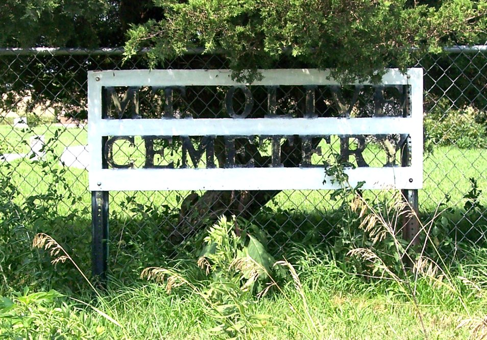
| Memorials | : | 16 |
| Location | : | Adrian Township, Jackson County, USA |
| Coordinate | : | 39.3694700, -96.0159500 |
| Description | : | Located in Adrian township at the intersection of B and 178 Roads, 4-1/2 miles north, 3 miles west, and 4-1/2 miles north of Delia, Kansas |
frequently asked questions (FAQ):
-
Where is Mount Olive Cemetery?
Mount Olive Cemetery is located at Adrian Township, Jackson County ,Kansas ,USA.
-
Mount Olive Cemetery cemetery's updated grave count on graveviews.com?
13 memorials
-
Where are the coordinates of the Mount Olive Cemetery?
Latitude: 39.3694700
Longitude: -96.0159500
Nearby Cemetories:
1. Little Cross Creek Cemetery
Jackson County, USA
Coordinate: 39.3652992, -95.9841995
2. Saint Clere Cemetery
Emmett, Pottawatomie County, USA
Coordinate: 39.3624992, -96.0622025
3. Adrian Cemetery
Jackson County, USA
Coordinate: 39.3185997, -95.9796982
4. Loughmiller Family Cemetery
Jackson County, USA
Coordinate: 39.4450500, -95.9988500
5. Mahkuk Family Cemetery
Mayetta, Jackson County, USA
Coordinate: 39.3372500, -95.9155850
6. Mary Matchie Cemetery
Mayetta, Jackson County, USA
Coordinate: 39.3420700, -95.9009700
7. Bucks Grove Church Cemetery
Soldier, Jackson County, USA
Coordinate: 39.4633293, -96.0158310
8. Boan Cemetery
Soldier, Jackson County, USA
Coordinate: 39.4350014, -95.9227982
9. Holy Cross Cemetery
Emmett, Pottawatomie County, USA
Coordinate: 39.2743988, -96.0466995
10. Fairview Cemetery
Onaga, Pottawatomie County, USA
Coordinate: 39.4356600, -96.1101300
11. John Mitchell Cemetery
Delia, Jackson County, USA
Coordinate: 39.3031500, -95.9178900
12. James Cemetery
Jackson County, USA
Coordinate: 39.4535800, -95.9424500
13. Danceground Cemetery
Mayetta, Jackson County, USA
Coordinate: 39.3102989, -95.8966980
14. Olive Hill Cemetery
Soldier, Jackson County, USA
Coordinate: 39.4631004, -95.9285965
15. Delia Cemetery
Delia, Jackson County, USA
Coordinate: 39.2606010, -95.9599991
16. Masquat Cemetery
Mayetta, Jackson County, USA
Coordinate: 39.3821180, -95.8620510
17. Vienna Cemetery
Pottawatomie County, USA
Coordinate: 39.4472198, -96.1466675
18. Prairie Peoples Cemetery
Mayetta, Jackson County, USA
Coordinate: 39.3180700, -95.8636000
19. Rosetta Rice Cemetery
Delia, Jackson County, USA
Coordinate: 39.2640300, -95.9012400
20. O'Bennick Cemetery
Mayetta, Jackson County, USA
Coordinate: 39.2884780, -95.8703270
21. Shipshee Cemetery
Mayetta, Jackson County, USA
Coordinate: 39.3039017, -95.8499985
22. Swede Wahwassuck Cemetery
Mayetta, Jackson County, USA
Coordinate: 39.3032700, -95.8434600
23. Havensville Cemetery
Havensville, Pottawatomie County, USA
Coordinate: 39.5119019, -96.0828018
24. Laclede Cemetery
Laclede, Pottawatomie County, USA
Coordinate: 39.3544006, -96.2205963