
| Memorials | : | 53 |
| Location | : | Baywood, Grayson County, USA |
| Coordinate | : | 36.5836240, -81.0071540 |
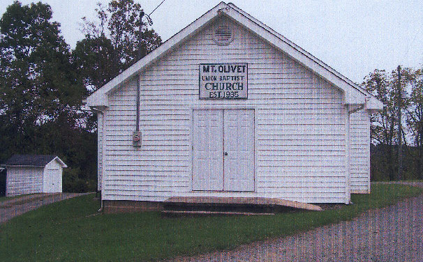
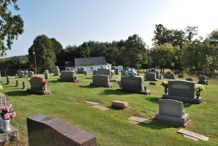
| Description | : | This cemetery is beside the Mt. Olivet Union Baptist Church. The church and cemetery are at the end of Mt. Olivet Road (Rt 707) 0.1 mile from Rolling Mill Lane (Rt 625). Baywood/Delhart area. Note that the mailing address/ZIP code is Galax which is an independent city in Virginia, not in Grayson County. The cemetery is in Grayson County. |
frequently asked questions (FAQ):
-
Where is Mount Olivet Union Baptist Church Cemetery?
Mount Olivet Union Baptist Church Cemetery is located at Mt Olivet Road (Rt. 707) Baywood, Grayson County ,Virginia , 24333USA.
-
Mount Olivet Union Baptist Church Cemetery cemetery's updated grave count on graveviews.com?
53 memorials
-
Where are the coordinates of the Mount Olivet Union Baptist Church Cemetery?
Latitude: 36.5836240
Longitude: -81.0071540
Nearby Cemetories:
1. Randolph Collins Cemetery
Baywood, Grayson County, USA
Coordinate: 36.5820400, -81.0134230
2. Galyean Cemetery
Baywood, Grayson County, USA
Coordinate: 36.5898720, -81.0007160
3. Andrew Higgins Farm Cemetery
Baywood, Grayson County, USA
Coordinate: 36.5954400, -81.0152800
4. Rector Family Cemetery
Delhart, Grayson County, USA
Coordinate: 36.5698020, -81.0042030
5. Linton Cemetery
Delhart, Grayson County, USA
Coordinate: 36.5886880, -80.9901280
6. Andrews Cemetery
Grayson County, USA
Coordinate: 36.5733740, -81.0235500
7. Whitaker Family Cemetery
Baywood, Grayson County, USA
Coordinate: 36.5932200, -81.0243800
8. A S Collins Cemetery
Baywood, Grayson County, USA
Coordinate: 36.5796022, -80.9863839
9. Austin-Murray Cemetery
Baywood, Grayson County, USA
Coordinate: 36.5888900, -81.0277800
10. McKnight Cemetery
Grayson County, USA
Coordinate: 36.5983490, -81.0207970
11. Curren Wilson Cemetery
Delhart, Grayson County, USA
Coordinate: 36.6025600, -81.0041600
12. King Family Cemetery
Baywood, Grayson County, USA
Coordinate: 36.6031580, -81.0144820
13. Jarvis Family Cemetery
Ennice, Alleghany County, USA
Coordinate: 36.5598620, -81.0121880
14. Jarvis Family Cemetery
Ennice, Alleghany County, USA
Coordinate: 36.5598620, -81.0121880
15. Wiley Collins Cemetery
Baywood, Grayson County, USA
Coordinate: 36.6086700, -81.0057300
16. Baywood Methodist Church Cemetery
Baywood, Grayson County, USA
Coordinate: 36.6076950, -81.0173970
17. Johnson Family Farm Cemetery
Oldtown, Grayson County, USA
Coordinate: 36.5709160, -81.0348010
18. Crossroads Primitive Baptist Church Cemetery
Baywood, Grayson County, USA
Coordinate: 36.6086820, -81.0159250
19. Todd - Wilson Cemetery (Defunct)
Baywood, Grayson County, USA
Coordinate: 36.6057700, -80.9894510
20. Hiram Higgins Family Cemetery
Ennice, Alleghany County, USA
Coordinate: 36.5598810, -80.9878160
21. Meredith Cheek Cemetery
Edwards Crossroads, Alleghany County, USA
Coordinate: 36.5625100, -81.0311900
22. David Nichols Family Cemetery
Baywood, Grayson County, USA
Coordinate: 36.5726960, -81.0402210
23. Brewer Family Cemetery
Baywood, Grayson County, USA
Coordinate: 36.6125600, -81.0071110
24. Hampton-Collins Cemetery
Baywood, Grayson County, USA
Coordinate: 36.6131910, -81.0007670