
| Memorials | : | 54 |
| Location | : | Doddridge County, USA |
| Coordinate | : | 39.4484020, -80.6205500 |
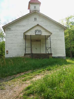
| Description | : | This Cemetery is located at the Head of Franks Run, Broad Run, Indian Creek,WV between 2 Counties Doddridge and Wetzel. It is 2.7 miles SSW of Center Point, WV and 3.4 miles WSW from Ashley, WV Driving directions from Clarksburg, WV 28.5 mi (about 48 mins) 1. Head northwest on US-50 14.0 mi 2. Turn right at Jacobs Run Rd/WV-23 Continue to follow WV-23 10.1 mi 3. Turn left to stay on WV-23 1.3 mi 4. Turn right at Franks Run 2.9 mi 5. Slight left at Co Hwy 6/2/Highway 62 397 ft --------- NOTE: Morgan Cemetery - near where Tyler, Doddridge & Wetzel... Read More |
frequently asked questions (FAQ):
-
Where is Mount Zion Church Cemetery?
Mount Zion Church Cemetery is located at Broad Run - Franks Run - Indian Creek Doddridge County ,West Virginia ,USA.
-
Mount Zion Church Cemetery cemetery's updated grave count on graveviews.com?
54 memorials
-
Where are the coordinates of the Mount Zion Church Cemetery?
Latitude: 39.4484020
Longitude: -80.6205500


Nearby Cemetories:
1. Morgan Cemetery
Doddridge County, USA
Coordinate: 39.4474983, -80.6224976
2. Morgan Cemetery #1
Tyler County, USA
Coordinate: 39.4476000, -80.6227000
3. Lyons Cemetery
Tyler County, USA
Coordinate: 39.4566994, -80.6382980
4. Swiger Cemetery
Doddridge County, USA
Coordinate: 39.4371790, -80.6393820
5. Main Cemetery
Dale, Tyler County, USA
Coordinate: 39.4580994, -80.6513977
6. Jeremiah Wilson Cemetery
Dale, Tyler County, USA
Coordinate: 39.4663610, -80.6570550
7. McIntyre Cemetery
Tyler County, USA
Coordinate: 39.4406000, -80.6639000
8. Carlin Cemetery
Archer, Wetzel County, USA
Coordinate: 39.4536770, -80.5671950
9. Ash Cemetery
Tyler County, USA
Coordinate: 39.4486000, -80.6839000
10. Ball Cemetery #2
Tyler County, USA
Coordinate: 39.4572220, -80.6850000
11. Lemasters Cemetery
Tyler County, USA
Coordinate: 39.4663467, -80.6819611
12. Ball Cemetery
Tyler County, USA
Coordinate: 39.4505560, -80.6866670
13. Noland-Albright Cemetery
Piney, Wetzel County, USA
Coordinate: 39.4829030, -80.6732470
14. Glaspell Family Cemetery
Center Point, Doddridge County, USA
Coordinate: 39.4274070, -80.5568590
15. Homer Cemetery
Dale, Tyler County, USA
Coordinate: 39.4458000, -80.6919000
16. Horner Family Cemetery
Tyler County, USA
Coordinate: 39.4458000, -80.6919000
17. Pleasant Baptist Church Cemetery
Center Point, Doddridge County, USA
Coordinate: 39.3923073, -80.6406555
18. Wyatt Cemetery
Tyler County, USA
Coordinate: 39.4467000, -80.6980000
19. Center Point Cemetery
Center Point, Doddridge County, USA
Coordinate: 39.3877983, -80.6333008
20. Five Oaks Cemetery
Tyler County, USA
Coordinate: 39.4471970, -80.7003708
21. Fairview Baptist Church Cemetery
Doddridge County, USA
Coordinate: 39.4267050, -80.5433940
22. Booth Cemetery
Wetzel County, USA
Coordinate: 39.5005989, -80.6844025
23. Hood Cemetery
Folsom, Wetzel County, USA
Coordinate: 39.4767730, -80.5318770
24. Anderson Cemetery
Jacksonburg, Wetzel County, USA
Coordinate: 39.5225900, -80.6140300