
| Memorials | : | 78 |
| Location | : | Farmington, Whitman County, USA |
| Coordinate | : | 47.0774500, -117.0409900 |
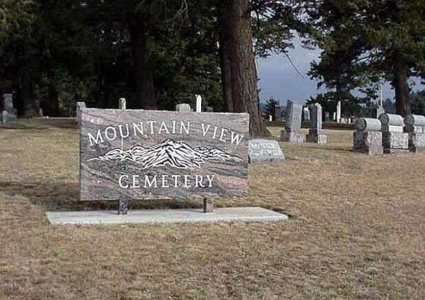
| Description | : | Genealogy questions and information about the purchase of plots may be directed to: Jerry Wagner 509-287-2343. Mountain View Cemetery holds much history. Even the stones reveal long forgotten stories. However, the first cemetery was begun in 1877, when John Ritchey was killed by 2 or 3 renegade Indians. It was on the old Breeding Farm, which bordered the state line with Idaho. George Truax founded the present site, then deeded it to the Masonic Lodge about 1882. There were maybe a half dozen graves relocated into the new cemetery from the old site across the border of Idaho.... Read More |
frequently asked questions (FAQ):
-
Where is Mountain View Cemetery?
Mountain View Cemetery is located at Farmington, Whitman County ,Washington ,USA.
-
Mountain View Cemetery cemetery's updated grave count on graveviews.com?
78 memorials
-
Where are the coordinates of the Mountain View Cemetery?
Latitude: 47.0774500
Longitude: -117.0409900
Nearby Cemetories:
1. Silver Creek Cemetery
Farmington, Whitman County, USA
Coordinate: 47.0344009, -117.0535965
2. Garfield Cemetery
Garfield, Whitman County, USA
Coordinate: 46.9999100, -117.1498600
3. Sacred Heart Mission Cemetery
De Smet, Benewah County, USA
Coordinate: 47.1461110, -116.9136110
4. Freeze Cemetery
Freeze, Latah County, USA
Coordinate: 46.9633000, -116.9492000
5. Goldenrod Cemetery
Tekoa, Whitman County, USA
Coordinate: 47.2117004, -117.0727997
6. Oakesdale Cemetery
Oakesdale, Whitman County, USA
Coordinate: 47.1371994, -117.2407990
7. Elberton Cemetery
Elberton, Whitman County, USA
Coordinate: 46.9821100, -117.2108300
8. Eden Valley Cemetery
Palouse, Whitman County, USA
Coordinate: 46.9407997, -117.1472015
9. Sacred Heart Catholic Cemetery
Tekoa, Whitman County, USA
Coordinate: 47.2398300, -117.0587100
10. Lone Pine Cemetery
Tekoa, Whitman County, USA
Coordinate: 47.2256012, -117.1489029
11. Mountain View Cemetery
Tensed, Benewah County, USA
Coordinate: 47.1064700, -116.7944700
12. Greenwood Cemetery
Palouse, Whitman County, USA
Coordinate: 46.9043999, -117.0686035
13. Mendenhall Cemetery
Latah County, USA
Coordinate: 46.9314000, -116.8752000
14. Potlatch Cemetery
Potlatch, Latah County, USA
Coordinate: 46.9226189, -116.8893814
15. Sanders Cemetery
Sanders, Benewah County, USA
Coordinate: 47.1014000, -116.7640000
16. Rock Creek Cemetery
Potlatch, Latah County, USA
Coordinate: 46.8914864, -116.8950260
17. Latah Cemetery
Latah, Spokane County, USA
Coordinate: 47.2821999, -117.1264038
18. Bethel Cemetery
Steptoe, Whitman County, USA
Coordinate: 47.0052986, -117.3460999
19. Latah Evergreen Cemetery
Latah, Spokane County, USA
Coordinate: 47.2961006, -117.1619034
20. Thornton Cemetery
Thornton, Whitman County, USA
Coordinate: 47.1146355, -117.3807907
21. Coleman Cemetery
Fallon, Whitman County, USA
Coordinate: 46.8444310, -117.0963620
22. Sheahan Cemetery
Thornton, Whitman County, USA
Coordinate: 47.1091000, -117.3868000
23. Viola Cemetery
Viola, Latah County, USA
Coordinate: 46.8380000, -117.0340000
24. Mount Olivet Cemetery
Colfax, Whitman County, USA
Coordinate: 46.8739014, -117.2275009