
| Memorials | : | 0 |
| Location | : | Munster, Departement du Haut-Rhin, France |
| Coordinate | : | 48.0427094, 7.1446218 |
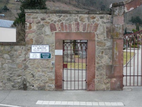
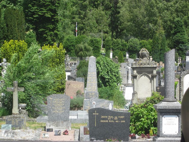
| Description | : | Munster is a small town approximately 15 km. west of Colmar. The communal cemetery is on the north-eastern side of the town, on the D10 road to Gunsbach. West of the lodge in the centre of the cemetery, and on the north-western side of the Military Plot, is the collective grave of 7 WWII airmen. One of them belonged to the Royal Air Force and the others to the Royal Canadian Air Force. |
frequently asked questions (FAQ):
-
Where is Munster Communal Cemetery?
Munster Communal Cemetery is located at Munster, Departement du Haut-Rhin ,Alsace ,France.
-
Munster Communal Cemetery cemetery's updated grave count on graveviews.com?
0 memorials
-
Where are the coordinates of the Munster Communal Cemetery?
Latitude: 48.0427094
Longitude: 7.1446218
Nearby Cemetories:
1. German War Cemetery Munster
Munster, Departement du Haut-Rhin, France
Coordinate: 48.0466861, 7.1464569
2. Cimetière intercommunal Gunsbach-Griesbach-au-Val
Gunsbach, Departement du Haut-Rhin, France
Coordinate: 48.0463439, 7.1791643
3. Breitenbach-Haut-Rhin German Soldiers' Cemetery
Breitenbach-Haut-Rhin, Departement du Haut-Rhin, France
Coordinate: 48.0174580, 7.0975520
4. Cimetière Militaire des Chasseurs
Orbey, Departement du Haut-Rhin, France
Coordinate: 48.0885600, 7.1175600
5. Nécropole Nationale du Bois de Maettle
Sondernach, Departement du Haut-Rhin, France
Coordinate: 47.9913842, 7.0720219
6. Ammerschwihr - Les Trois-Epis Deutscher Soldatenfr
Ammerschwihr, Departement du Haut-Rhin, France
Coordinate: 48.1024700, 7.2320700
7. Cimetière communal de Turckheim
Turckheim, Departement du Haut-Rhin, France
Coordinate: 48.0874832, 7.2770526
8. Cimetière communal de Wintzenheim
Wintzenheim, Departement du Haut-Rhin, France
Coordinate: 48.0731689, 7.2909947
9. Jewish Cemetery
Herrlisheim-pres-Colmar, Departement du Haut-Rhin, France
Coordinate: 48.0118405, 7.3147106
10. Cimetière Ingersheim
Ingersheim, Departement du Haut-Rhin, France
Coordinate: 48.1016400, 7.3040000
11. 1st Regiment de Chasseurs d'Afrique
Kaysersberg, Departement du Haut-Rhin, France
Coordinate: 48.1392060, 7.2633780
12. Cimetière Communal
Le Bonhomme, Departement du Haut-Rhin, France
Coordinate: 48.1711314, 7.1109810
13. Notre Dame de l'Assomption
Rouffach, Departement du Haut-Rhin, France
Coordinate: 47.9583330, 7.2983330
14. Cimetière National Français de la Waldmartt
Guebwiller, Departement du Haut-Rhin, France
Coordinate: 47.9034946, 7.2010922
15. Nécropole Nationale de Sigolsheim
Sigolsheim, Departement du Haut-Rhin, France
Coordinate: 48.1406116, 7.3082487
16. Cimetière de la Collégiale Saint Martin (Defunct)
Colmar, Departement du Haut-Rhin, France
Coordinate: 48.0775987, 7.3585428
17. Cimetière Communal Guebwiller
Guebwiller, Departement du Haut-Rhin, France
Coordinate: 47.9049950, 7.2277310
18. Cimetière communal
Plainfaing, Departement des Vosges, France
Coordinate: 48.1747957, 7.0180207
19. Cimetière du Ladhof
Colmar, Departement du Haut-Rhin, France
Coordinate: 48.0935669, 7.3724241
20. Haut Rhin
Mittelwihr, Departement du Haut-Rhin, France
Coordinate: 48.1526829, 7.3196691
21. Colmar Deutscher Soldatenfriedhof
Colmar, Departement du Haut-Rhin, France
Coordinate: 48.0957500, 7.3714900
22. Nécropole nationale de Colmar
Colmar, Departement du Haut-Rhin, France
Coordinate: 48.0951901, 7.3738872
23. Église St-Maurice
Soultz-Haut-Rhin, Departement du Haut-Rhin, France
Coordinate: 47.8860000, 7.2297000
24. Saint-Jacques-le-Majeur of Hunawih
Hunawihr, Departement du Haut-Rhin, France
Coordinate: 48.1787900, 7.3103200