
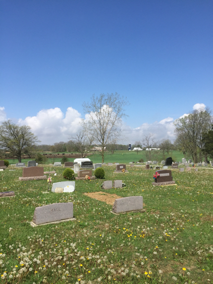
| Memorials | : | 9 |
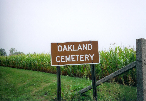
| Location | : | Gettysburg, Darke County, USA |
| Coordinate | : | 40.1541939, -84.5044403 |
| Description | : | The cemetery is located on the north side of Martin Road (Township Road 169) about 0.25 miles north of its intersection with Horatio-Harris Creek Road (County Road 32). The cemetery is located in Adams Township, Darke County, Ohio, and is # 2677 (Oakland Cemetery) in “Ohio Cemeteries 1803-2003”, compiled by the Ohio Genealogical Society. The cemetery is registered with the Ohio Division of Real Estate and Professional Licensing (ODRE) as Oakland Cemetery with registration license number CGR.0000981559. The U.S. Geological Survey (USGS) Geographic Names Information System (GNIS) feature ID for the cemetery is 1806192 (Oakland Cemetery). |
frequently asked questions (FAQ):
-
Where is Oakland Cemetery?
Oakland Cemetery is located at Martin Road (Township Road 169) Gettysburg, Darke County ,Ohio , 45308USA.
-
Oakland Cemetery cemetery's updated grave count on graveviews.com?
9 memorials
-
Where are the coordinates of the Oakland Cemetery?
Latitude: 40.1541939
Longitude: -84.5044403
Nearby Cemetories:
1. Miller Cemetery
Darke County, USA
Coordinate: 40.1522700, -84.4694500
2. Stoner Cemetery
Stelvideo, Darke County, USA
Coordinate: 40.1786003, -84.5192032
3. Erisman Cemetery
Adams Township, Darke County, USA
Coordinate: 40.1361008, -84.5410995
4. Stelvideo Cemetery
Darke County, USA
Coordinate: 40.1655998, -84.5516968
5. Byrd Cemetery
Adams Township, Darke County, USA
Coordinate: 40.1783150, -84.4643670
6. Coppess Cemetery
Richland Township, Darke County, USA
Coordinate: 40.1753006, -84.5475006
7. Christian Cemetery
Adams Township, Darke County, USA
Coordinate: 40.1737530, -84.4578910
8. Gettysburg Cemetery
Gettysburg, Darke County, USA
Coordinate: 40.1073570, -84.4946060
9. Hartle-Miller Cemetery
Richland Township, Darke County, USA
Coordinate: 40.1914294, -84.5491156
10. Saint Peters Lutheran Church Cemetery
Webster, Darke County, USA
Coordinate: 40.1953310, -84.4657230
11. Hoover Cemetery
Versailles, Darke County, USA
Coordinate: 40.2061005, -84.4938965
12. Old Harris Creek Cemetery
Darke County, USA
Coordinate: 40.1523323, -84.4336700
13. Harris Creek Cemetery
Bradford, Miami County, USA
Coordinate: 40.1492320, -84.4312640
14. Mott Cemetery
Gettysburg, Darke County, USA
Coordinate: 40.1051480, -84.4656910
15. Rarick Burial Ground
Miami County, USA
Coordinate: 40.1660680, -84.4273570
16. Wise Cemetery
Miami County, USA
Coordinate: 40.1383590, -84.4207160
17. Beamsville Cemetery
Beamsville, Darke County, USA
Coordinate: 40.1841660, -84.5886078
18. Greenlawn Cemetery
Versailles, Darke County, USA
Coordinate: 40.2250390, -84.4905190
19. Saint Johns Lutheran Cemetery
Greenville, Darke County, USA
Coordinate: 40.1344300, -84.5948600
20. East Zion Cemetery
Greenville, Darke County, USA
Coordinate: 40.1051000, -84.5747600
21. Brumbaugh Cemetery
Miami County, USA
Coordinate: 40.1626080, -84.4094180
22. Bradford Cemetery
Bradford, Miami County, USA
Coordinate: 40.1096992, -84.4282990
23. Friedens Cemetery
Covington, Miami County, USA
Coordinate: 40.1809200, -84.4140630
24. Beanblossom Cemetery
Beamsville, Darke County, USA
Coordinate: 40.1899390, -84.5955740