
| Memorials | : | 41 |
| Location | : | Öckerö, Öckerö kommun, Sweden |
| Phone | : | +46(31)7643100 |
| Website | : | www.svenskakyrkan.se/ockero/kyrkogard |
| Coordinate | : | 57.7068300, 11.6440400 |
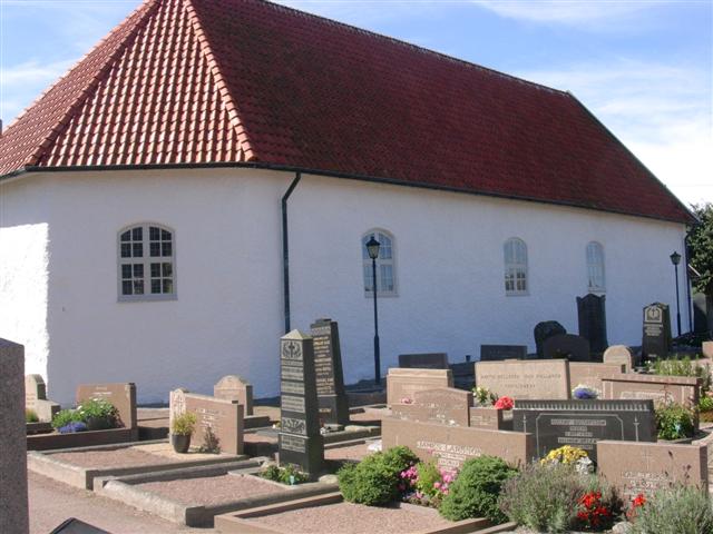
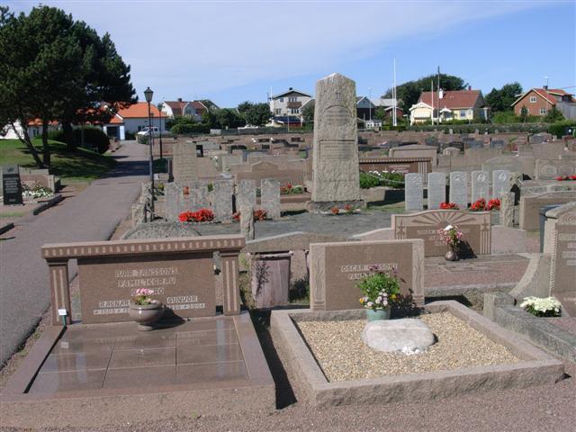
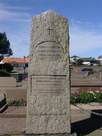
| Description | : | Ockero is an island off the south-west coast of Sweden, lying north of the entrance to Gothenburg harbour. From the E6 turn onto the 155 in the direction of Ockero. Take the ferry to the island and the church can clearly be seen on the hill to the right. Although Sweden remained neutral throughout both world wars, a number of Commonwealth servicemen lie buried in her cemeteries and churchyards. Most of the First World War burials are of Naval casualties from the Battle of Jutland in 1916. The Second World War graves are mostly those of airmen who failed to... Read More |
frequently asked questions (FAQ):
-
Where is Ockero Churchyard?
Ockero Churchyard is located at Ekelundsvägen 44 Öckerö, Öckerö kommun ,Västra Götalands län , 475 32Sweden.
-
Ockero Churchyard cemetery's updated grave count on graveviews.com?
40 memorials
-
Where are the coordinates of the Ockero Churchyard?
Latitude: 57.7068300
Longitude: 11.6440400
Nearby Cemetories:
1. Hönö kyrkogård
Hono, Öckerö kommun, Sweden
Coordinate: 57.6860006, 11.6632342
2. Torslanda Cemetery
Torslanda, Göteborgs kommun, Sweden
Coordinate: 57.7250486, 11.7690514
3. Brännö kyrkogård
Göteborg, Göteborgs kommun, Sweden
Coordinate: 57.6515290, 11.7812350
4. Björlanda Cemetery
Torslanda, Göteborgs kommun, Sweden
Coordinate: 57.7614320, 11.8245678
5. Nya Varvets Kyrkogård
Göteborg, Göteborgs kommun, Sweden
Coordinate: 57.6810950, 11.8877560
6. Bräcke Kolera kyrkogård
Göteborgs kommun, Sweden
Coordinate: 57.7033035, 11.9000722
7. Donsö kyrkogård
Donso, Göteborgs kommun, Sweden
Coordinate: 57.5980726, 11.8034854
8. Lundby Nya Kyrkogård
Göteborg, Göteborgs kommun, Sweden
Coordinate: 57.7087306, 11.9103806
9. Lundby gamla kyrkogård
Lundby, Göteborgs kommun, Sweden
Coordinate: 57.7124440, 11.9155300
10. Mariebergs kyrkogård
Göteborg, Göteborgs kommun, Sweden
Coordinate: 57.6928600, 11.9234000
11. Västra Kyrkogården
Göteborg, Göteborgs kommun, Sweden
Coordinate: 57.6826310, 11.9213664
12. Vrångö gamla kyrkogård
Vrango, Göteborgs kommun, Sweden
Coordinate: 57.5781658, 11.7897676
13. Djurgårdskyrkogården
Göteborg, Göteborgs kommun, Sweden
Coordinate: 57.6929048, 11.9364363
14. Säve kyrkogård
Göteborgs kommun, Sweden
Coordinate: 57.8030897, 11.9185882
15. Marstrand Kyrkogård
Marstrand, Kungälvs kommun, Sweden
Coordinate: 57.8860083, 11.5828237
16. Stampens Kyrkogård
Göteborg, Göteborgs kommun, Sweden
Coordinate: 57.7037766, 11.9855921
17. Askims Södra kyrkogård
Hovas, Göteborgs kommun, Sweden
Coordinate: 57.6157113, 11.9416889
18. Friedländerska Enskilda Begravningsplatsen
Backa, Göteborgs kommun, Sweden
Coordinate: 57.7550400, 11.9779900
19. Marstrands Cemetery on Koön
Marstrand, Kungälvs kommun, Sweden
Coordinate: 57.8903600, 11.5994000
20. Fridhems kyrkogård
Göteborgs kommun, Sweden
Coordinate: 57.7648160, 11.9750440
21. Örgryte gamla kyrkogård
Göteborg, Göteborgs kommun, Sweden
Coordinate: 57.6983642, 11.9988884
22. Sankt Pauli kyrkogård
Göteborg, Göteborgs kommun, Sweden
Coordinate: 57.7143280, 12.0032080
23. Tåns kyrkogård
Göteborgs kommun, Sweden
Coordinate: 57.7103884, 12.0061813
24. Östra Kyrkogården
Göteborg, Göteborgs kommun, Sweden
Coordinate: 57.7159950, 12.0064570