
| Memorials | : | 0 |
| Location | : | Athol, Worcester County, USA |
| Coordinate | : | 42.5889840, -72.2270420 |
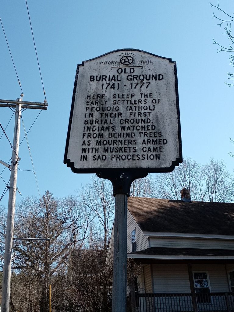
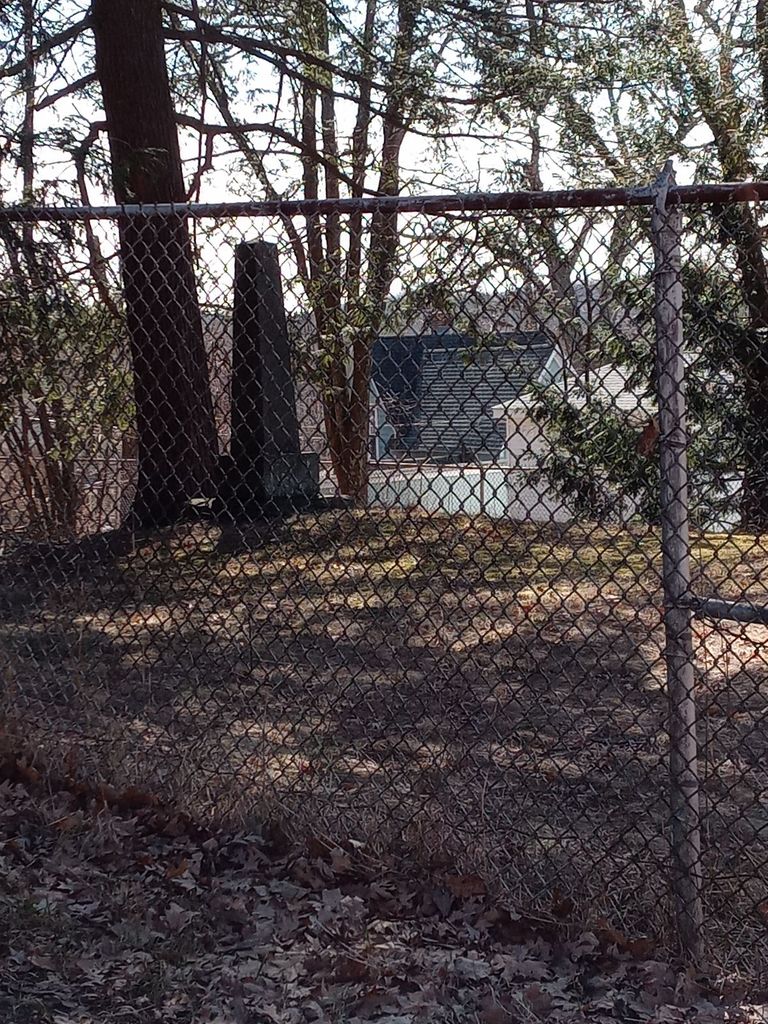
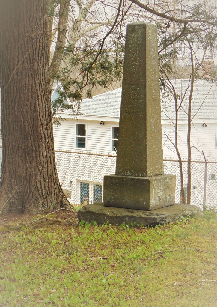
| Description | : | "Here sleep the early settlers of Pequoig (Athol) in their first burial ground. Indians watched from behind the trees as mourners came with muskets armed in sad procession." -Athol History Trail marker How many pioneers were buried here is not certain. At one time 40 graves could be clearly traced. A few of the names are known. Residents still debate whether Indians also were buried here, but there is no firm tradition or proof. In its center is seen the First Settlers' Monument, raised on July 4, 1859 by school children pulling on a rope. Athol History Train booklet,... Read More |
frequently asked questions (FAQ):
-
Where is Old Burial Ground?
Old Burial Ground is located at Athol, Worcester County ,Massachusetts ,USA.
-
Old Burial Ground cemetery's updated grave count on graveviews.com?
0 memorials
-
Where are the coordinates of the Old Burial Ground?
Latitude: 42.5889840
Longitude: -72.2270420
Nearby Cemetories:
1. Old Pleasant Street Cemetery
Athol, Worcester County, USA
Coordinate: 42.5860800, -72.2145100
2. Highland Cemetery
Athol, Worcester County, USA
Coordinate: 42.5889015, -72.2110977
3. Calvary Cemetery
Athol, Worcester County, USA
Coordinate: 42.5842018, -72.2117004
4. Silver Lake Cemetery
Athol, Worcester County, USA
Coordinate: 42.6018982, -72.2249985
5. Mount Pleasant Cemetery
Athol, Worcester County, USA
Coordinate: 42.5943985, -72.2433014
6. Gethsemane Cemetery
Athol, Worcester County, USA
Coordinate: 42.5791960, -72.2578310
7. Ellinwood Cemetery
Athol, Worcester County, USA
Coordinate: 42.5589400, -72.2142600
8. Jones Cemetery
Orange, Franklin County, USA
Coordinate: 42.6148224, -72.2728806
9. Fay Cemetery
Athol, Worcester County, USA
Coordinate: 42.5466300, -72.2364200
10. Chestnut Hill Cemetery
Athol, Worcester County, USA
Coordinate: 42.6296997, -72.2042007
11. Adams Road Cemetery
Athol, Worcester County, USA
Coordinate: 42.5425560, -72.2133610
12. Stratton Cemetery
Athol, Worcester County, USA
Coordinate: 42.5407872, -72.2151265
13. New Sherborn Cemetery
Athol, Worcester County, USA
Coordinate: 42.5402985, -72.2166977
14. Tully Cemetery
Orange, Franklin County, USA
Coordinate: 42.6398000, -72.2504700
15. North Orange Cemetery
Orange, Franklin County, USA
Coordinate: 42.6360230, -72.2690530
16. Central Cemetery
Orange, Franklin County, USA
Coordinate: 42.5932960, -72.3066420
17. South Cemetery
Orange, Franklin County, USA
Coordinate: 42.5657880, -72.3043410
18. Harvard Cemetery
Petersham, Worcester County, USA
Coordinate: 42.5305000, -72.1896100
19. Branch Bridge Cemetery
New Salem, Franklin County, USA
Coordinate: 42.5337500, -72.2743640
20. Maple Cemetery
Royalston, Worcester County, USA
Coordinate: 42.6545520, -72.2235460
21. Northwest Cemetery
Petersham, Worcester County, USA
Coordinate: 42.5210991, -72.2268982
22. Lower Cemetery
Phillipston, Worcester County, USA
Coordinate: 42.5583000, -72.1425018
23. Riverside Cemetery
Royalston, Worcester County, USA
Coordinate: 42.6302986, -72.1453018
24. Nahum Greene Gravesite
Royalston, Worcester County, USA
Coordinate: 42.6545700, -72.1712900