
| Memorials | : | 0 |
| Location | : | Busby, Lawrence County, USA |
| Coordinate | : | 35.1277050, -87.4347730 |
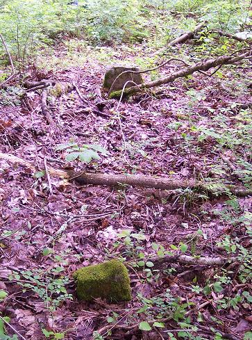
| Description | : | Before 1916, the Lawrence County "Poor" Farm was located on Shoal Creek at Busby, Tennessee. This cemetery is on private land and very difficult to locate. The graves are all marked with unscribed natural stones. There are about 3 rows of approximately 7 visible graves. This graveyard is where the poor residents of the County Farm were interred at death. The stones are in a small grove of hardwood and cedar trees surrounded by pine trees. This grave yard is located about 300 yards from the County farm buildings which are present, but are collapsing. The graves are 1 mile... Read More |
frequently asked questions (FAQ):
-
Where is Old County Farm Cemetery?
Old County Farm Cemetery is located at 1.6 miles off of Hwy 43 on Busby Road, Right on Jaxton Ln 1 mile. Busby, Lawrence County ,Tennessee ,USA.
-
Old County Farm Cemetery cemetery's updated grave count on graveviews.com?
0 memorials
-
Where are the coordinates of the Old County Farm Cemetery?
Latitude: 35.1277050
Longitude: -87.4347730
Nearby Cemetories:
1. Busbee Cemetery
Loretto, Lawrence County, USA
Coordinate: 35.1082411, -87.4085555
2. Clack Branch Cemetery
Lawrence County, USA
Coordinate: 35.1035995, -87.4664001
3. Belew Cemetery
Long Branch, Lawrence County, USA
Coordinate: 35.1600700, -87.4110500
4. Belew Cemetery
Long Branch, Lawrence County, USA
Coordinate: 35.1652100, -87.4204300
5. Cedar Hill Cemetery
Lawrence County, USA
Coordinate: 35.1488991, -87.3925018
6. Restview Cemetery
Loretto, Lawrence County, USA
Coordinate: 35.0826900, -87.4331600
7. Hensley Ridge Cemetery
Lawrence County, USA
Coordinate: 35.1156006, -87.4886017
8. Blue Water Cemetery
Lawrence County, USA
Coordinate: 35.0946999, -87.3833008
9. Sacred Heart Cemetery
Loretto, Lawrence County, USA
Coordinate: 35.0724900, -87.4454100
10. Loretto Cemetery
Loretto, Lawrence County, USA
Coordinate: 35.0718994, -87.4475021
11. Loretto Memorial Gardens
Loretto, Lawrence County, USA
Coordinate: 35.0714550, -87.4460220
12. Fuller Chapel Cemetery
Lawrence County, USA
Coordinate: 35.1363983, -87.3581009
13. Collier Cemetery
Lawrence County, USA
Coordinate: 35.1917000, -87.4044037
14. Crews Cemetery
Deerfield, Lawrence County, USA
Coordinate: 35.1960983, -87.4505997
15. Ander Smith Cemetery
Lawrence County, USA
Coordinate: 35.1852989, -87.3842010
16. Chinubee Cemetery
Lawrence County, USA
Coordinate: 35.1147003, -87.5203018
17. McClain Cemetery
Lawrence County, USA
Coordinate: 35.1913986, -87.4822006
18. Bishop Chapel Cemetery
Lawrence County, USA
Coordinate: 35.0643997, -87.3833008
19. Clayton-Beeler Cemetery
Lawrence County, USA
Coordinate: 35.2036896, -87.4227219
20. Freemon Cemetery
Lawrence County, USA
Coordinate: 35.1493988, -87.3432999
21. Nelson Cemetery
Crewstown, Lawrence County, USA
Coordinate: 35.1960983, -87.3824997
22. Leoma Cemetery
Leoma, Lawrence County, USA
Coordinate: 35.1617012, -87.3450012
23. Center Point Baptist Church Cemetery
Leoma, Lawrence County, USA
Coordinate: 35.1103517, -87.3375888
24. Center Point United Methodist Church Cemetery
Lawrence County, USA
Coordinate: 35.1062220, -87.3385570