
| Memorials | : | 0 |
| Location | : | Fayette, Jefferson County, USA |
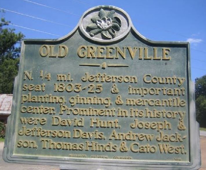
| Description | : | Old Greenville, Mississippi town cemetery may have been established as early as 1798 and received burials up to 1825 and later. According to the book, Mississippi; a Guide to the Magnolia State, the outlaws in the Samuel Mason Gang, Wiley Harpe and Peter Alston were convicted and hanged on February 8, 1804 at the Gallows Field in Old Greenville, Mississippi. There heads were cut off and displayed on sharpened wood poles, along the north and south ends of the Natchez Trace, as a warning to other criminals. The headless of corpes of Harpe and Alston were buried in the... Read More |
frequently asked questions (FAQ):
-
Where is Old Greenville Cemetery?
Old Greenville Cemetery is located at No GPS information available Add GPSLocated in former town site of Old Greenville near present-day Mississippi Historical Marker Fayette, Jefferson County ,Mississippi , 39069USA.
-
Old Greenville Cemetery cemetery's updated grave count on graveviews.com?
0 memorials
Nearby Cemetories:
1. Barland Cemetery
Jefferson County, USA
Coordinate: 31.6871200, -91.1914400
2. Bell Grove Cemetery
Jefferson County, USA
Coordinate: 31.6286010, -91.2033580
3. Little Zion Cemetery
Blue Hill, Jefferson County, USA
Coordinate: 31.6285500, -91.2034900
4. Nevels Cemetery
Blue Hill, Jefferson County, USA
Coordinate: 31.6691600, -91.1887900
5. Singletary Cemetery
Blue Hill, Jefferson County, USA
Coordinate: 31.6142006, -91.0535965
6. Trevillion Cemetery
Blue Hill, Jefferson County, USA
Coordinate: 31.6395100, -90.7786400
7. Woods Cemetery
Blue Hill, Jefferson County, USA
Coordinate: 31.7264004, -90.7388992
8. Bethlehem Baptist Church Cemetery
Cannonsburg, Jefferson County, USA
Coordinate: 31.7346992, -91.0500031
9. Chamberlain Cemetery
Cannonsburg, Jefferson County, USA
10. Cole Family Cemetery
Cannonsburg, Jefferson County, USA
Coordinate: 31.7450330, -91.1480660
11. Davenport Family Cemetery
Cannonsburg, Jefferson County, USA
Coordinate: 31.6760998, -90.8283005
12. McKnight Family Cemetery
Cannonsburg, Jefferson County, USA
13. Mount Locust Slave Cemetery
Cannonsburg, Jefferson County, USA
Coordinate: 31.6871200, -91.1914400
14. Saint James African Methodist Episcopal Church
Cannonsburg, Jefferson County, USA
Coordinate: 31.6286010, -91.2033580
15. Saint James Baptist Church Cemetery
Cannonsburg, Jefferson County, USA
Coordinate: 31.6285500, -91.2034900
16. Tyler-Frisby Cemetery
Cannonsburg, Jefferson County, USA
Coordinate: 31.6691600, -91.1887900
17. Old Rose Hill Cemetery
Jefferson County, USA
Coordinate: 31.6142006, -91.0535965
18. Piedmont Baptist Church
Jefferson County, USA
Coordinate: 31.6395100, -90.7786400
19. Pleasant Hill Cemetery
Pleasant Hill, Jefferson County, USA
Coordinate: 31.7264004, -90.7388992
20. Stuart Cemetery
Jefferson County, USA
Coordinate: 31.7346992, -91.0500031
21. Suggs Family Cemetery
Jefferson County, USA
22. Taylor Chapel Baptist Church Cemetery
Jefferson County, USA
Coordinate: 31.7450330, -91.1480660
23. Hickory Block Cemetery
Union Church, Jefferson County, USA
Coordinate: 31.6760998, -90.8283005
24. Mount Comet Cemetery
Union Church, Jefferson County, USA