
| Memorials | : | 9 |
| Location | : | Roach, Camden County, USA |
| Coordinate | : | 37.9922800, -92.8341500 |
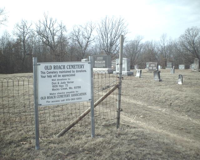
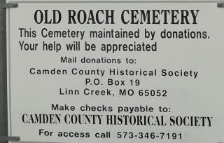
| Description | : | The UE Roach Cemetery is located on the south side of old Hwy 54 and 200 yards north of the present Hwy 54 on State Hwy AA. When Union Electric Company built Bagnell Dam, Lake of the Ozarks was created, flooding the Osage and Niangua River Bottoms and covering many of the oldest cemeteries in Camden County. Union Electric Company bought ground near Roach, Mo., and moved 286 bodies to this site. From lower Prairie Hollow (207), Moulder (46) and smaller numbers from the following cemeteries: Edwards, Laurie, Donzelot, Shockley, Rains, Libby, John McCrory, Roach, Crabtree, WP Jackson Farm,... Read More |
frequently asked questions (FAQ):
-
Where is Old Roach Cemetery?
Old Roach Cemetery is located at 89–159 State Road AA Roach, Camden County ,Missouri , 65787USA.
-
Old Roach Cemetery cemetery's updated grave count on graveviews.com?
9 memorials
-
Where are the coordinates of the Old Roach Cemetery?
Latitude: 37.9922800
Longitude: -92.8341500
Nearby Cemetories:
1. Niangua Cemetery
Roach, Camden County, USA
Coordinate: 37.9934200, -92.8360400
2. Laughlin Cemetery
Camdenton, Camden County, USA
Coordinate: 37.9921989, -92.8032990
3. Webster Cemetery
Camdenton, Camden County, USA
Coordinate: 37.9728012, -92.7972031
4. Baker Cemetery
Camden County, USA
Coordinate: 37.9571991, -92.8377991
5. Pleasant Grove Cemetery
Macks Creek, Camden County, USA
Coordinate: 37.9466500, -92.8744900
6. New Home Cemetery
Camdenton, Camden County, USA
Coordinate: 38.0325012, -92.7830963
7. Lodge Cemetery
Hahatonka, Camden County, USA
Coordinate: 37.9641991, -92.7688980
8. Dale Blair Memorial Cemetery
Camdenton, Camden County, USA
Coordinate: 38.0037117, -92.7605591
9. Parrack Grove Cemetery
Macks Creek, Camden County, USA
Coordinate: 38.0115814, -92.9054337
10. Saint Anthonys Catholic Cemetery
Camdenton, Camden County, USA
Coordinate: 38.0272320, -92.7658640
11. Warren Cemetery
Camden County, USA
Coordinate: 38.0525017, -92.8822021
12. Our Savior's Lutheran Church Columbarium
Camdenton, Camden County, USA
Coordinate: 38.0132100, -92.7390300
13. Wiley Gott Cemetery
Camden County, USA
Coordinate: 37.9206009, -92.8818970
14. Caviness Cemetery
Camdenton, Camden County, USA
Coordinate: 37.9872017, -92.7283020
15. Hedges-Scott Cemetery
Camden County, USA
Coordinate: 37.9989700, -92.7239100
16. Mills Cemetery
Camden County, USA
Coordinate: 37.8993988, -92.8621979
17. Raggs Cemetery
Camden County, USA
Coordinate: 38.0597000, -92.9231033
18. Dickerson Cemetery
Camden County, USA
Coordinate: 37.8958015, -92.8110962
19. Allee Memorial Gardens
Camdenton, Camden County, USA
Coordinate: 37.9874687, -92.7043228
20. Farmer Cemetery
Hurricane Deck, Camden County, USA
Coordinate: 38.0950012, -92.7981033
21. A. B. Union Church Cemetery
Tunas, Dallas County, USA
Coordinate: 37.8939018, -92.8906326
22. Selby-Hall Cemetery
Linn Creek, Camden County, USA
Coordinate: 38.0367012, -92.7074966
23. Myetta Cemetery
Camdenton, Camden County, USA
Coordinate: 37.9614100, -92.7010600
24. Old Linn Creek Cemetery
Camden County, USA
Coordinate: 38.0738983, -92.7386017