
| Memorials | : | 0 |
| Location | : | Honesdale, Wayne County, USA |
| Coordinate | : | 41.5687140, -75.2564890 |
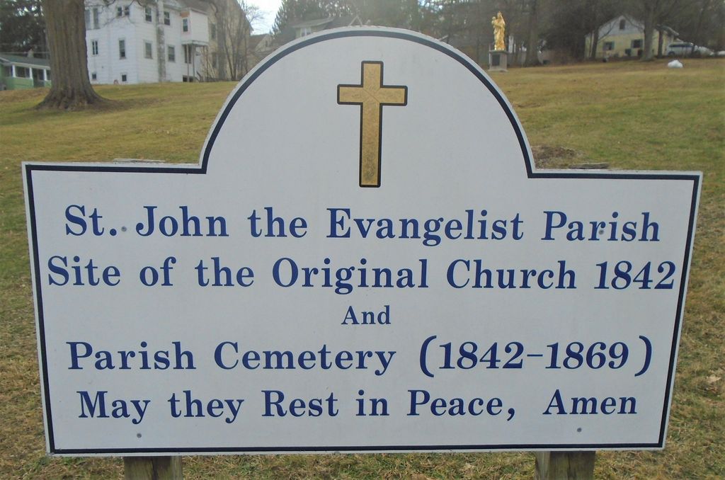
| Description | : | Established in 1842, Saint John the Evangelist Church was the first Catholic parish in Honesdale. The old church building (which disappeared after the 1890s) was replaced in the 1870s by the current church, located immediately adjacent to the site. According to an announcement in the Wayne County Herald (April 1866), the old parish cemetery was to discontinue interments on June 1, 1866. A similar notice in the same newspaper (May 1866) noted that land for a new cemetery had been purchased south of town (the site of the current St. John the Evangelist Catholic Cemetery). According to the parish, graves... Read More |
frequently asked questions (FAQ):
-
Where is Old Saint John the Evangelist Church Cemetery?
Old Saint John the Evangelist Church Cemetery is located at Corner of Carroll and Vine Streets Honesdale, Wayne County ,Pennsylvania , 18431USA.
-
Old Saint John the Evangelist Church Cemetery cemetery's updated grave count on graveviews.com?
0 memorials
-
Where are the coordinates of the Old Saint John the Evangelist Church Cemetery?
Latitude: 41.5687140
Longitude: -75.2564890

Nearby Cemetories:
1. Old Honesdale Cemetery
Honesdale, Wayne County, USA
Coordinate: 41.5741850, -75.2588230
2. Saint John The Evangelist Roman Catholic Cemetery
Honesdale, Wayne County, USA
Coordinate: 41.5622000, -75.2501000
3. Glen Dyberry Cemetery
Honesdale, Wayne County, USA
Coordinate: 41.5833015, -75.2589035
4. Saint Johns Lutheran Cemetery
Honesdale, Wayne County, USA
Coordinate: 41.5850190, -75.2603820
5. Beth Israel Cemetery
Honesdale, Wayne County, USA
Coordinate: 41.5853160, -75.2584830
6. Saint Mary Magdalen Cemetery
Honesdale, Wayne County, USA
Coordinate: 41.5874050, -75.2616130
7. Schoonover Cemetery
Honesdale, Wayne County, USA
Coordinate: 41.5926000, -75.2647000
8. Berlin Valley Cemetery
Wayne County, USA
Coordinate: 41.5930000, -75.2237000
9. Darling Cemetery
Cherry Ridge, Wayne County, USA
Coordinate: 41.5386925, -75.2928467
10. Indian Orchard Cemetery
Indian Orchard, Wayne County, USA
Coordinate: 41.5447400, -75.2127540
11. Nelson Cemetery
Dyberry, Wayne County, USA
Coordinate: 41.6191500, -75.2600040
12. Smith Hill Cemetery
Honesdale, Wayne County, USA
Coordinate: 41.6111150, -75.2179280
13. Bethany Cemetery
Bethany, Wayne County, USA
Coordinate: 41.6154500, -75.2880510
14. Prompton Cemetery
Wayne County, USA
Coordinate: 41.5830490, -75.3256610
15. Glass Factory Cemetery
Bethany, Wayne County, USA
Coordinate: 41.6232986, -75.3107986
16. Saint Patricks Mission Church Cemetery
Fermoy, Wayne County, USA
Coordinate: 41.5500630, -75.3483530
17. Vine Hill Cemetery
Wayne County, USA
Coordinate: 41.5918999, -75.1658020
18. Torrey Cemetery
Wayne County, USA
Coordinate: 41.6345060, -75.1930370
19. Beach Lake Cemetery
Beach Lake, Wayne County, USA
Coordinate: 41.6042000, -75.1530000
20. East Dyberry Cemetery
Dyberry, Wayne County, USA
Coordinate: 41.6543010, -75.2693720
21. Keen Cemetery
Wayne County, USA
Coordinate: 41.5929000, -75.3686000
22. Jonathan Brink Family Cemetery
White Mills, Wayne County, USA
Coordinate: 41.4899883, -75.1956269
23. Bayley Cemetery
Waymart, Wayne County, USA
Coordinate: 41.6180800, -75.3808100
24. Queen of Peace Cemetery
Hawley, Wayne County, USA
Coordinate: 41.4715000, -75.1839000