
| Memorials | : | 5 |
| Location | : | Benton, Grafton County, USA |
| Coordinate | : | 43.9978145, -71.9209265 |
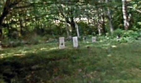
| Description | : | Located one tenth of a mile from the intersection of Route 25 and Oliverian Road, on the left (southwest) side of Oliverian Road. Only four gravestones visible. The name of this cemetery is subject to change. According to "Some Things About Coventry-Benton New Hampshire", by William F. Whitcher, dated 1905, on page 219, this cemetery is described as being on "the Meadows on the A. L. Warren farm, but only a few of the graves are marked." The description names three of the four gravestones seen at present. The cemetery is not named in this... Read More |
frequently asked questions (FAQ):
-
Where is Oliverian Road Cemetery?
Oliverian Road Cemetery is located at Benton, Grafton County ,New Hampshire ,USA.
-
Oliverian Road Cemetery cemetery's updated grave count on graveviews.com?
5 memorials
-
Where are the coordinates of the Oliverian Road Cemetery?
Latitude: 43.9978145
Longitude: -71.9209265
Nearby Cemetories:
1. High Street Cemetery
Glencliff, Grafton County, USA
Coordinate: 43.9851100, -71.8913900
2. Lund Cemetery
Warren, Grafton County, USA
Coordinate: 43.9882800, -71.9589200
3. Number 6 Cemetery
East Haverhill, Grafton County, USA
Coordinate: 44.0326400, -71.9518600
4. Rodimon-Cross Cemetery
Piermont, Grafton County, USA
Coordinate: 43.9901100, -71.9924500
5. East Haverhill Cemetery
East Haverhill, Grafton County, USA
Coordinate: 44.0289688, -71.9889297
6. Pine Hill Cemetery
Warren, Grafton County, USA
Coordinate: 43.9370003, -71.8929977
7. East Piermont Cemetery
Piermont, Grafton County, USA
Coordinate: 43.9438890, -71.9689890
8. Warren Village Cemetery
Warren, Grafton County, USA
Coordinate: 43.9326200, -71.8917600
9. Clay Hollow Cemetery
Piermont, Grafton County, USA
Coordinate: 43.9597220, -72.0333330
10. Clough Cemetery
Warren, Grafton County, USA
Coordinate: 43.9090200, -71.8878800
11. Center Haverhill Cemetery
Center Haverhill, Grafton County, USA
Coordinate: 44.0770650, -71.9868740
12. Brown Farmstead Cemetery
Benton, Grafton County, USA
Coordinate: 44.0778000, -71.8420830
13. East Cemetery
Benton, Grafton County, USA
Coordinate: 44.0985985, -71.8846970
14. Ladd Street Cemetery
Haverhill, Grafton County, USA
Coordinate: 44.0439600, -72.0532800
15. East Orford Cemetery
Orford, Grafton County, USA
Coordinate: 43.9096900, -72.0032600
16. West Cemetery
Benton, Grafton County, USA
Coordinate: 44.1033700, -71.9014000
17. Abbott Cemetery
North Haverhill, Grafton County, USA
Coordinate: 44.0821730, -72.0186420
18. East Side Cemetery
Wentworth, Grafton County, USA
Coordinate: 43.8837000, -71.9002200
19. Cedar Grove Cemetery
Piermont, Grafton County, USA
Coordinate: 43.9720300, -72.0813400
20. South Lawn Cemetery
Piermont, Grafton County, USA
Coordinate: 43.9667600, -72.0812500
21. Foster Cemetery
Wentworth, Grafton County, USA
Coordinate: 43.8708100, -71.9127800
22. Wentworth Village Cemetery
Wentworth, Grafton County, USA
Coordinate: 43.8707280, -71.9128410
23. Oxbow Cemetery
Newbury, Orange County, USA
Coordinate: 44.0881830, -72.0486670
24. River Road Cemetery
Piermont, Grafton County, USA
Coordinate: 44.0019500, -72.1013600