
| Memorials | : | 1 |
| Location | : | Ouderkerk aan den IJssel, Krimpenerwaard Municipality, Netherlands |
| Coordinate | : | 51.9322220, 4.6361110 |
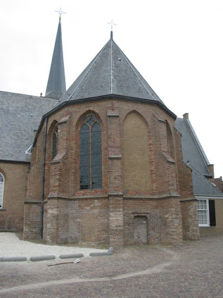
| Description | : | Parts of the church date from the 12th century. Between 1425 and 1428 it was destroyed and then rebuilt as a cruciform church. In 1661 a vault was constructed in the choir, by order of Lodewijk van Nassau-Beverweerd [43983818]. The first who was buried there was his wife Isabella in 1664, followed by 33 others. The last interment took place in 1824. In 1753 Count Willem Maurits (1679-1753) ordered the construction of a monument. It was made or blue stone and its height is 7 m., its breadth 6 m. In 1798 Countess Maria Wilhelmina [44149279] ordered for fear of... Read More |
frequently asked questions (FAQ):
-
Where is Ouderkerk aan den IJssel Nederlands Hervormde Kerk?
Ouderkerk aan den IJssel Nederlands Hervormde Kerk is located at Ouderkerk aan den IJssel, Krimpenerwaard Municipality ,Zuid-Holland ,Netherlands.
-
Ouderkerk aan den IJssel Nederlands Hervormde Kerk cemetery's updated grave count on graveviews.com?
1 memorials
-
Where are the coordinates of the Ouderkerk aan den IJssel Nederlands Hervormde Kerk?
Latitude: 51.9322220
Longitude: 4.6361110
Nearby Cemetories:
1. Begraafplaats De essehof
Nieuwerkerk aan den IJssel, Zuidplas Municipality, Netherlands
Coordinate: 51.9599272, 4.6087006
2. Oude Begraafplaats Nieuwerkerk aan den IJssel
Nieuwerkerk aan den IJssel, Zuidplas Municipality, Netherlands
Coordinate: 51.9646128, 4.6186162
3. Oude Begraafplaats
Capelle aan den IJssel, Capelle aan den IJssel Municipality, Netherlands
Coordinate: 51.9166860, 4.5755210
4. Joodse Begraafplaats
Lekkerkerk, Krimpenerwaard Municipality, Netherlands
Coordinate: 51.9026200, 4.6836500
5. Algemene begraafplaats Lekkerkerk
Lekkerkerk, Krimpenerwaard Municipality, Netherlands
Coordinate: 51.8986600, 4.6967709
6. Oude Algemene Begraafplaats
Nieuw-Lekkerland, Molenwaard Municipality, Netherlands
Coordinate: 51.8921164, 4.6930499
7. Oud Kralingen Algemene Begraafplaats
Rotterdam, Rotterdam Municipality, Netherlands
Coordinate: 51.9320000, 4.5481900
8. Begraafplaats en Uitvaartcentrum IJsselmonde
IJsselmonde, Rotterdam Municipality, Netherlands
Coordinate: 51.9002288, 4.5558824
9. Joodse Begraafplaats Toepad
Rotterdam, Rotterdam Municipality, Netherlands
Coordinate: 51.9088890, 4.5322220
10. Begraafplaats Vredehof
Ridderkerk, Ridderkerk Municipality, Netherlands
Coordinate: 51.8683230, 4.5891290
11. Alblasserdam General Cemetery
Alblasserdam, Alblasserdam Municipality, Netherlands
Coordinate: 51.8620100, 4.6682900
12. Joodse begraafplaats Oostzeedijk
Rotterdam Municipality, Netherlands
Coordinate: 51.9219440, 4.5036110
13. Achterambacht Algemene Begraafplaats
Hendrik-Ido-Ambacht, Hendrik-Ido-Ambacht Municipality, Netherlands
Coordinate: 51.8489900, 4.6108200
14. Gouda Old Cemetery
Gouda, Gouda Municipality, Netherlands
Coordinate: 52.0064100, 4.7068900
15. Begraafplaats Sint Laurentius
Rotterdam, Rotterdam Municipality, Netherlands
Coordinate: 51.9342100, 4.4958500
16. Rotterdam Crooswijk General Cemetery
Rotterdam, Rotterdam Municipality, Netherlands
Coordinate: 51.9393500, 4.4911600
17. Protestantse Begraafplaats Hillegersberg
Hillegersberg-Schiebroek, Rotterdam Municipality, Netherlands
Coordinate: 51.9559332, 4.4934316
18. Joods begraafplaats Jan van Loonslaan
Rotterdam Municipality, Netherlands
Coordinate: 51.9252400, 4.4883000
19. Barendrecht General Cemetery
Barendrecht, Barendrecht Municipality, Netherlands
Coordinate: 51.8593700, 4.5382500
20. Gouda Ijsselhof Cemetery
Gouda, Gouda Municipality, Netherlands
Coordinate: 52.0095400, 4.7268000
21. Rotterdam Zuiderbegraafplaats
Rotterdam, Rotterdam Municipality, Netherlands
Coordinate: 51.8763300, 4.5045100
22. RK begraafplaats Gouda
Gouda, Gouda Municipality, Netherlands
Coordinate: 52.0174067, 4.7190455
23. Krimpen aan de Lek Cemetery
Krimpenerwaard Municipality, Netherlands
Coordinate: 51.9833330, 4.7833330
24. Rooms Katholieke Begraafplaats Bleiswijk
Bleiswijk, Lansingerland Municipality, Netherlands
Coordinate: 52.0146067, 4.5324334