
| Memorials | : | 0 |
| Location | : | Ellis County, USA |
| Coordinate | : | 35.8798100, -99.7361000 |
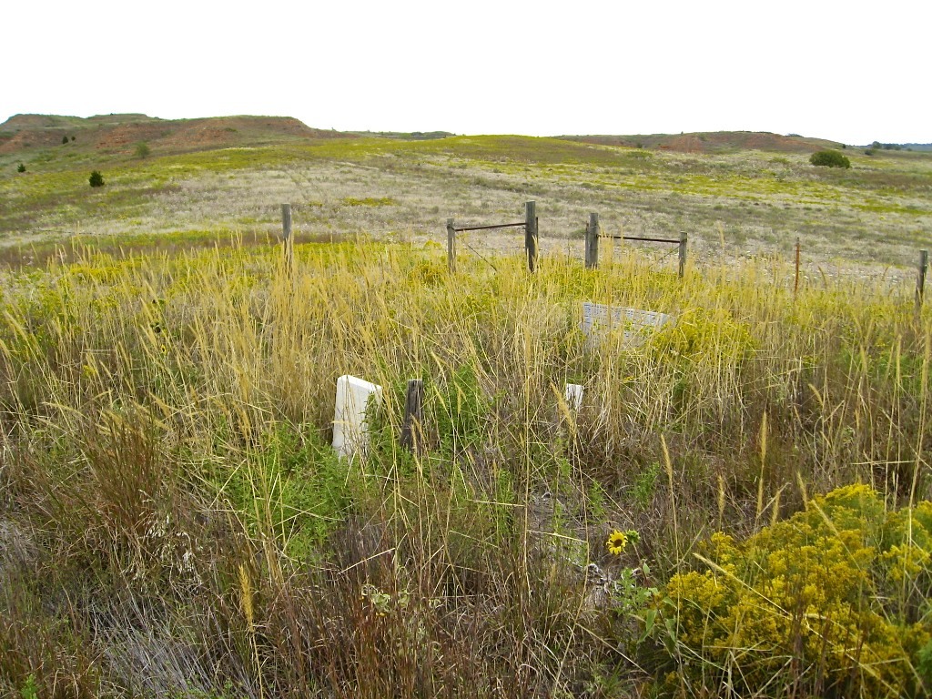
| Description | : | Ellis County Historical Society's description shows the cemetery is on land owned by the Oklahoma Department of Wildlife. Permission should be obtained to cross private land before reaching the wildlife area. At this time there is not an actual road to the cemetery from the access road. Packsaddle Cemetery, in the rolling prairie between Cheyenne and Arnett, Oklahoma. No sign exists, and only a few locals know its location way off Highway 283. Map coordinates are: 35D 52M 47.31S N by 99D 44M 11.66S W at 2097 ft elev. |
frequently asked questions (FAQ):
-
Where is Packsaddle Cemetery?
Packsaddle Cemetery is located at Ellis County ,Oklahoma ,USA.
-
Packsaddle Cemetery cemetery's updated grave count on graveviews.com?
0 memorials
-
Where are the coordinates of the Packsaddle Cemetery?
Latitude: 35.8798100
Longitude: -99.7361000
Nearby Cemetories:
1. Pie Flat Cemetery
Roger Mills County, USA
Coordinate: 35.8363991, -99.7106018
2. Silent Home Cemetery
Roll, Roger Mills County, USA
Coordinate: 35.7972500, -99.7465940
3. Lone Bell Cemetery
Ellis County, USA
Coordinate: 35.8614006, -99.6188965
4. Fairview Cemetery
Durham, Roger Mills County, USA
Coordinate: 35.8638992, -99.8897018
5. Bellview Cemetery
Roger Mills County, USA
Coordinate: 35.9564018, -99.8677979
6. Sunrise Cemetery
Roger Mills County, USA
Coordinate: 35.7503014, -99.8174973
7. Grand Cemetery
Ellis County, USA
Coordinate: 36.0130997, -99.8178024
8. Rhome Cemetery
Roger Mills County, USA
Coordinate: 35.7761002, -99.5702972
9. Eddie Cemetery
Ellis County, USA
Coordinate: 36.0435000, -99.6311400
10. Ioland Cemetery
Ellis County, USA
Coordinate: 35.9449997, -99.5227966
11. Ike Watkins Gravesite
Arnett, Ellis County, USA
Coordinate: 35.9439370, -99.5217820
12. Lone Tree Cemetery
Ellis County, USA
Coordinate: 35.9399986, -99.9617004
13. Lone Star-Archer Cemetery
Roger Mills County, USA
Coordinate: 35.7937300, -99.5132200
14. Center Chapel Cemetery
Roger Mills County, USA
Coordinate: 35.9350014, -99.4847031
15. Wagoner Cemetery
Strong City, Roger Mills County, USA
Coordinate: 35.7469440, -99.5208330
16. Allmon Cemetery
Arnett, Ellis County, USA
Coordinate: 36.0710983, -99.8768997
17. Brown Family Cemetery
Arnett, Ellis County, USA
Coordinate: 36.0696400, -99.8828900
18. Union Chapel Cemetery
Roger Mills County, USA
Coordinate: 35.7263985, -99.9542007
19. Red Star Cemetery
Roger Mills County, USA
Coordinate: 35.8413887, -99.4469376
20. Strong City Cemetery
Strong City, Roger Mills County, USA
Coordinate: 35.6636505, -99.6056595
21. Snakey Bend Cemetery
Strong City, Roger Mills County, USA
Coordinate: 35.6516991, -99.6147003
22. Lone Star Cemetery
Ellis County, USA
Coordinate: 36.0572014, -99.5152969
23. Chapel Hill Cemetery
Roger Mills County, USA
Coordinate: 35.6718700, -99.5529700
24. Black Home Burial
Arnett, Ellis County, USA
Coordinate: 36.0224500, -99.4647200