
| Memorials | : | 0 |
| Location | : | Pahala, Hawaii County, USA |
| Coordinate | : | 19.1970130, -155.4729800 |
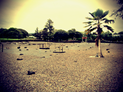
| Description | : | Following Mamalahoa Hwy from east to west, this cemetery is right past the medical center, on your right. It is the first cemetery among three plantation cemeteries (Filipino, Chinese, Japanese). There is an entryway, but it is not labeled. Many of the stones have only a number, or are simply lava rocks. The entry way has a Lion's Club logo, leading me to believe the cemetery preservation is in the hands of the local Lion's Club. |
frequently asked questions (FAQ):
-
Where is Pahala Filipino Methodist Cemetery?
Pahala Filipino Methodist Cemetery is located at 96-1113 Paauau Pl Pahala, Hawaii County ,Hawaii , 96777USA.
-
Pahala Filipino Methodist Cemetery cemetery's updated grave count on graveviews.com?
0 memorials
-
Where are the coordinates of the Pahala Filipino Methodist Cemetery?
Latitude: 19.1970130
Longitude: -155.4729800

Nearby Cemetories:
1. Pahala Chinese Cemetery
Pahala, Hawaii County, USA
Coordinate: 19.1975600, -155.4727970
2. Holy Rosary Catholic Church Cemetery
Pahala, Hawaii County, USA
Coordinate: 19.2031000, -155.4769000
3. Hoku Loa Congregational Christian Church Cemetery
Punaluu, Hawaii County, USA
Coordinate: 19.1335800, -155.5073300
4. Naalehu Cemetery
Naalehu, Hawaii County, USA
Coordinate: 19.0646000, -155.5879000
5. Kauahaao Congregational Church Cemetery
Waiohinu, Hawaii County, USA
Coordinate: 19.0678620, -155.6121350
6. Kalahiki Cemetery
Hawaii County, USA
Coordinate: 19.3750000, -155.8762000
7. Saint Benedicts Catholic Church Cemetery
Honaunau, Hawaii County, USA
Coordinate: 19.4352000, -155.8887000
8. City of Refuge Cemetery
Honaunau, Hawaii County, USA
Coordinate: 19.4247070, -155.9102500
9. Keei Buddhist Church and Cemetery
Honaunau, Hawaii County, USA
Coordinate: 19.4574270, -155.8917150
10. Saints Family Cemetery
Keei, Hawaii County, USA
Coordinate: 19.4581560, -155.8922300
11. Mountain View Community Cemetery
Mountain View, Hawaii County, USA
Coordinate: 19.5516200, -155.1058300
12. Kahikolu Congregational Cemetery
Captain Cook, Hawaii County, USA
Coordinate: 19.4695320, -155.9152600
13. Saint John the Baptist Catholic Church Cemetery
Captain Cook, Hawaii County, USA
Coordinate: 19.5015460, -155.9197190
14. Kealakekua Bay
Captain Cook, Hawaii County, USA
Coordinate: 19.4830400, -155.9332500
15. Old Japanese Cemetery
Kurtistown, Hawaii County, USA
Coordinate: 19.5679000, -155.0841000
16. Christ Church Episcopal Cemetery
Kealakekua, Hawaii County, USA
Coordinate: 19.5081700, -155.9187800
17. Central Kona Union Church Cemetery
Kealakekua, Hawaii County, USA
Coordinate: 19.5085940, -155.9201790
18. Kona Hongwanji Mission Cemetery
Kealakekua, Hawaii County, USA
Coordinate: 19.5160000, -155.9186000
19. Kurtistown Filipino Cemetery
Kurtistown, Hawaii County, USA
Coordinate: 19.5767800, -155.0667000
20. Lanakila Congregational Church Cemetery
Kainaliu, Hawaii County, USA
Coordinate: 19.5348400, -155.9288700
21. Ola'a First Hawaiian Church Cemetery
Kurtistown, Hawaii County, USA
Coordinate: 19.5837110, -155.0599730
22. Kona Daifukuji Soto Mission Cemetery
Kealakekua, Hawaii County, USA
Coordinate: 19.5426000, -155.9275000
23. Saint Paul's Catholic Cemetery
Honalo, Hawaii County, USA
Coordinate: 19.5412700, -155.9314000
24. Tong Wo Tong Cemetery
Kealakekua, Hawaii County, USA
Coordinate: 19.5539920, -155.9346470