
| Memorials | : | 0 |
| Location | : | Glass, Obion County, USA |
| Coordinate | : | 36.2602070, -89.2573340 |
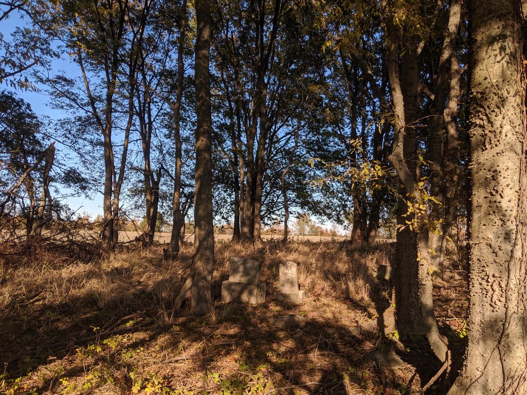
| Description | : | Not maintained. From the Highway 51/I-69 exit west of Obion, continue west for 2.3 miles. Turn left (south) on Sharps Ferry Road. Continue for approximately 1,600 feet. The cemetery is in a grove of trees about 0.1 of a mile on the east side of the road. This cemetery is believed to have once been the community cemetery of Palestine due to the variety of surnames found here, even though it has been given many unofficial names in the past, such as Taylor, Timberman, and Starrett. Palestine was once a thriving community that was at least the size of Obion.... Read More |
frequently asked questions (FAQ):
-
Where is Palestine Cemetery?
Palestine Cemetery is located at Sharps Ferry Road Glass, Obion County ,Tennessee ,USA.
-
Palestine Cemetery cemetery's updated grave count on graveviews.com?
0 memorials
-
Where are the coordinates of the Palestine Cemetery?
Latitude: 36.2602070
Longitude: -89.2573340
Nearby Cemetories:
1. Simpson Hill Cemetery
Obion, Obion County, USA
Coordinate: 36.2521590, -89.2500030
2. Hadley-Parks Cemetery
Glass, Obion County, USA
Coordinate: 36.2482460, -89.2582360
3. Mills Cemetery
Mount Moriah, Obion County, USA
Coordinate: 36.2888890, -89.2522220
4. Fox Cemetery
Obion, Obion County, USA
Coordinate: 36.2624670, -89.2209960
5. Oak Ridge Church of Christ Cemetery
Elbridge, Obion County, USA
Coordinate: 36.2828550, -89.2959020
6. Oak Ridge Cemetery
Obion County, USA
Coordinate: 36.2783012, -89.3007965
7. Beard Cemetery
Troy, Obion County, USA
Coordinate: 36.2977982, -89.2300034
8. Mount Moriah Cemetery
Troy, Obion County, USA
Coordinate: 36.3019000, -89.2328000
9. Hendricks Cemetery
Elbridge, Obion County, USA
Coordinate: 36.2167330, -89.2769010
10. Elbridge Cemetery
Obion, Obion County, USA
Coordinate: 36.2619200, -89.3236400
11. Moses Wright Gravesite
Obion, Obion County, USA
Coordinate: 36.2832780, -89.1970760
12. Thompson Cemetery
Obion, Obion County, USA
Coordinate: 36.2667790, -89.3251550
13. Rose Hill Cemetery
Obion, Obion County, USA
Coordinate: 36.2717018, -89.1800003
14. Bethlehem Cemetery
Troy, Obion County, USA
Coordinate: 36.3148900, -89.2173340
15. Lippard Cemetery
Cloverdale, Obion County, USA
Coordinate: 36.2450070, -89.3352650
16. Beech Grove Cemetery
Obion, Obion County, USA
Coordinate: 36.2914000, -89.1869000
17. Obion Chapel Cemetery
Hornbeak, Obion County, USA
Coordinate: 36.3320720, -89.2578030
18. Graves Chapel Cemetery
Hornbeak, Obion County, USA
Coordinate: 36.3331440, -89.2567170
19. Via Cemetery
Elbridge, Obion County, USA
Coordinate: 36.2555556, -89.3481694
20. Long Cemetery
Elbridge, Obion County, USA
Coordinate: 36.2556500, -89.3483440
21. Campground Cemetery
Camp Ground, Obion County, USA
Coordinate: 36.3149800, -89.1960600
22. Pierce Cemetery
Trimble, Dyer County, USA
Coordinate: 36.1996210, -89.2041830
23. New Campground Cemetery
Troy, Obion County, USA
Coordinate: 36.3168460, -89.1967820
24. Goodman Cemetery
Troy, Obion County, USA
Coordinate: 36.3348270, -89.2498700