| Memorials | : | 0 |
| Location | : | Rheingau-Taunus-Kreis, Germany |
| Coordinate | : | 49.9792300, 7.9239600 |
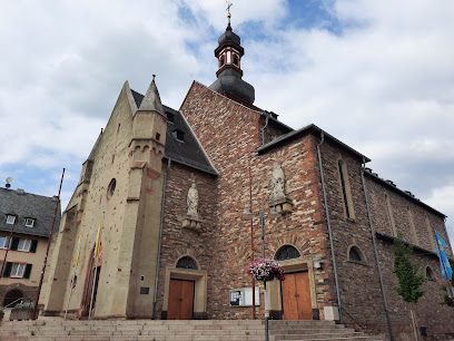
| Description | : | The Catholic parish church of St. James the Apostle is a grade II listed Church in Rüdesheim. The oldest parts of the building are located in the basement of the North Tower. The early Romanesque chapel dating back to the 11th century. During a severe air raid during of the second world war in Rüdesheim, the Church burnt out on November 25, 1944. A large part of the inventory fell victim to fire. From 1946 to 1956, rebuilding of the Church in a modified form and in 1959 set up the Spire. |
frequently asked questions (FAQ):
-
Where is Pfarrkirche St. Jakobus?
Pfarrkirche St. Jakobus is located at Rüdesheim am Rhein Rheingau-Taunus-Kreis ,Hessen , 65385Germany.
-
Pfarrkirche St. Jakobus cemetery's updated grave count on graveviews.com?
0 memorials
-
Where are the coordinates of the Pfarrkirche St. Jakobus?
Latitude: 49.9792300
Longitude: 7.9239600
Nearby Cemetories:
1. Friedhof Rüdesheim am Rhein
Rüdesheim am Rhein, Rheingau-Taunus-Kreis, Germany
Coordinate: 49.9842100, 7.9414800
2. Jüdische Friedhof
Rüdesheim am Rhein, Rheingau-Taunus-Kreis, Germany
Coordinate: 49.9834595, 7.9422207
3. Abtei St. Hildegard
Eibingen, Rheingau-Taunus-Kreis, Germany
Coordinate: 49.9928420, 7.9287090
4. Jewish Cemetery
Bingen am Rhein, Landkreis Mainz-Bingen, Germany
Coordinate: 49.9617295, 7.9006683
5. Weiler
Weiler bei Bingen, Landkreis Mainz-Bingen, Germany
Coordinate: 49.9559028, 7.8697942
6. Schloßkapelle
Trechtingshausen, Landkreis Mainz-Bingen, Germany
Coordinate: 49.9896423, 7.8579141
7. Friedhof Frei-Weinheim
Ingelheim am Rhein, Landkreis Mainz-Bingen, Germany
Coordinate: 49.9911542, 8.0316346
8. Friedhof Grolsheim
Landkreis Mainz-Bingen, Germany
Coordinate: 49.9069900, 7.9184200
9. Evangelische Kirche Waldlaubersheim
Waldlaubersheim, Landkreis Bad Kreuznach, Germany
Coordinate: 49.9287820, 7.8334000
10. Friedhof Gensingen
Gensingen, Landkreis Mainz-Bingen, Germany
Coordinate: 49.8999951, 7.9233923
11. Friedhof Langenlonsheim
Langenlonsheim, Landkreis Bad Kreuznach, Germany
Coordinate: 49.8933884, 7.8967011
12. Sankt Remigius Kirche
Landkreis Mainz-Bingen, Germany
Coordinate: 49.9762560, 8.0652140
13. Burgkirche
Ingelheim am Rhein, Landkreis Mainz-Bingen, Germany
Coordinate: 49.9635250, 8.0635920
14. Friedhof Lorch
Lorch, Rheingau-Taunus-Kreis, Germany
Coordinate: 50.0438553, 7.8065637
15. Jüdischer Friedhof Bretzenheim
Bretzenheim, Landkreis Bad Kreuznach, Germany
Coordinate: 49.8801500, 7.8981800
16. Kloster Eberbach in Eltville am Rhein
Mainz, Stadtkreis Mainz, Germany
Coordinate: 50.0425000, 8.0466700
17. Pfarrkirche St. Martin
Rheingau-Taunus-Kreis, Germany
Coordinate: 50.0441670, 7.8033330
18. Evangelische Kirche Windesheim
Windesheim, Landkreis Bad Kreuznach, Germany
Coordinate: 49.9046960, 7.8157110
19. Friedhof Bacharach
Bacharach, Landkreis Mainz-Bingen, Germany
Coordinate: 50.0455956, 7.7819442
20. Friedhof Bubenheim
Bubenheim, Landkreis Mainz-Bingen, Germany
Coordinate: 49.9233758, 8.0789769
21. Friedhof Winzenheim
Winzenheim, Landkreis Bad Kreuznach, Germany
Coordinate: 49.8719134, 7.8608964
22. Schwabenheim
Schwabenheim, Landkreis Mainz-Bingen, Germany
Coordinate: 49.9332600, 8.0955200
23. Katholische Pfarrkirche St. Valentinus und Dionys
Kiedrich, Rheingau-Taunus-Kreis, Germany
Coordinate: 50.0411670, 8.0847220
24. Stift Pfaffen-Schwabenheim
Pfaffen-Schwabenheim, Landkreis Bad Kreuznach, Germany
Coordinate: 49.8516670, 7.9527780

