
| Memorials | : | 0 |
| Location | : | Hodgenville, LaRue County, USA |
| Coordinate | : | 37.5834940, -85.7325840 |
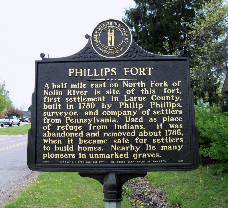
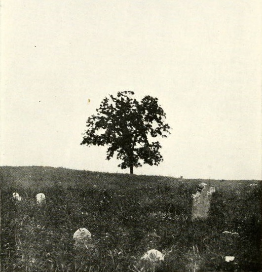
| Description | : | [Source: "The Mather Papers" by Otis M. MATHER, pg. 46] "The following listing of the Phillips Fort Cemetery was copied by Otis M. Mather on April 11, 1920 on the A. B. Twyman farm. In 1967 the farm was owned by Adrian Atherton. Today the cemetery is extinct as it was bulldozed several years ago. According to ATHS member James D. LaRue, Jr. "We have the cemetery plotted on a topographical map. The stones were all removed and thrown in a ditch. I salvaged a footstone." |
frequently asked questions (FAQ):
-
Where is Phillip's Fort Cemetery?
Phillip's Fort Cemetery is located at Hodgenville, LaRue County ,Kentucky ,USA.
-
Phillip's Fort Cemetery cemetery's updated grave count on graveviews.com?
0 memorials
-
Where are the coordinates of the Phillip's Fort Cemetery?
Latitude: 37.5834940
Longitude: -85.7325840
Nearby Cemetories:
1. Red Hill Cemetery
Hodgenville, LaRue County, USA
Coordinate: 37.5717010, -85.7307968
2. Our Lady of Mercy Catholic Church Cemetery
Hodgenville, LaRue County, USA
Coordinate: 37.5675200, -85.7312080
3. Hubbard Cemetery
Hodgenville, LaRue County, USA
Coordinate: 37.5674710, -85.7430280
4. Stonehouse Loop Cemetery
Hodgenville, LaRue County, USA
Coordinate: 37.5855052, -85.7014367
5. Hodgenville Pentecostal Church Cemetery
LaRue County, USA
Coordinate: 37.5586440, -85.7156480
6. Victory Baptist Church Cemetery
Hodgenville, LaRue County, USA
Coordinate: 37.5499210, -85.7383410
7. Hill Family Cemetery
LaRue County, USA
Coordinate: 37.5450500, -85.7466600
8. Friendship Baptist Church Cemetery
Hodgenville, LaRue County, USA
Coordinate: 37.6144000, -85.6863000
9. Nolynn Baptist Church Cemetery
LaRue County, USA
Coordinate: 37.5604320, -85.7896740
10. Pleasant Grove Cemetery
Hodgenville, LaRue County, USA
Coordinate: 37.5874040, -85.6630170
11. Lincoln Memorial Baptist Cemetery
LaRue County, USA
Coordinate: 37.5281850, -85.7285430
12. Castleman Cemetery
Hodgenville, LaRue County, USA
Coordinate: 37.6408005, -85.7292023
13. Oak Grove Church Cemetery
LaRue County, USA
Coordinate: 37.5631030, -85.6636670
14. Salem Christian Church Cemetery
LaRue County, USA
Coordinate: 37.6299660, -85.6852540
15. Round Top Baptist Church Cemetery
Elizabethtown, Hardin County, USA
Coordinate: 37.6185830, -85.8004760
16. Middle Creek Baptist Church Cemetery
Hodgenville, LaRue County, USA
Coordinate: 37.6486000, -85.7405000
17. Saint Joachim Cemetery
Hodgenville, LaRue County, USA
Coordinate: 37.5828018, -85.6466980
18. Big Spring Cemetery
LaRue County, USA
Coordinate: 37.5718994, -85.8227997
19. George Redmon Family Cemetery
LaRue County, USA
Coordinate: 37.5988700, -85.6419210
20. Buffalo Baptist Cemetery
Buffalo, LaRue County, USA
Coordinate: 37.5141100, -85.7018990
21. Coombs-Williams Family Cemetery
Hodgenville, LaRue County, USA
Coordinate: 37.5670040, -85.8229980
22. Daugherty Cemetery
LaRue County, USA
Coordinate: 37.6571999, -85.7311020
23. Potts Spring Cemetery
LaRue County, USA
Coordinate: 37.6481018, -85.6817017
24. South Fork Baptist Church Cemetery
LaRue County, USA
Coordinate: 37.5064760, -85.7423500