
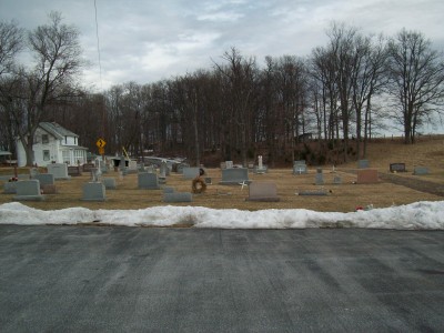
| Memorials | : | 33 |
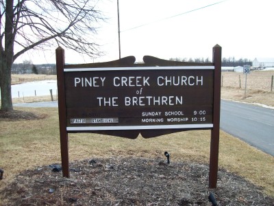
| Location | : | Taneytown, Carroll County, USA |
| Phone | : | 410-756-2820 |
| Coordinate | : | 39.7033005, -77.1536026 |
frequently asked questions (FAQ):
-
Where is Piney Creek Church of the Brethren Cemetery?
Piney Creek Church of the Brethren Cemetery is located at 4699 Teeter Road Taneytown, Carroll County ,Maryland , 21787USA.
-
Piney Creek Church of the Brethren Cemetery cemetery's updated grave count on graveviews.com?
33 memorials
-
Where are the coordinates of the Piney Creek Church of the Brethren Cemetery?
Latitude: 39.7033005
Longitude: -77.1536026
Nearby Cemetories:
1. Saint James Reformed Cemetery
Mount Joy Township, Adams County, USA
Coordinate: 39.7312000, -77.1583000
2. Piney Creek Reformed Presbyterian Church Cemetery
Taneytown, Carroll County, USA
Coordinate: 39.6984500, -77.1977600
3. Sunrise Cemetery
Harney, Carroll County, USA
Coordinate: 39.7125015, -77.2031021
4. Trinity Lutheran Cemetery
Taneytown, Carroll County, USA
Coordinate: 39.6626900, -77.1760600
5. Mountain View Cemetery
Harney, Carroll County, USA
Coordinate: 39.7196500, -77.2098600
6. Grace United Church of Christ Cemetery
Taneytown, Carroll County, USA
Coordinate: 39.6610000, -77.1795800
7. Saint Josephs Catholic Church Cemetery
Taneytown, Carroll County, USA
Coordinate: 39.6579800, -77.1791900
8. Baptist Road Cemetery
Taneytown, Carroll County, USA
Coordinate: 39.6706900, -77.2023900
9. Saint John's Lutheran Cemetery
Germany Township, Adams County, USA
Coordinate: 39.7434000, -77.1030000
10. Mount Pleasant United Methodist Cemetery
Taneytown, Carroll County, USA
Coordinate: 39.6455994, -77.1508026
11. Mount Carmel Cemetery
Littlestown, Adams County, USA
Coordinate: 39.7397003, -77.0892029
12. Saint Aloysius Cemetery
Germany Township, Adams County, USA
Coordinate: 39.7364006, -77.0793991
13. Mount Joy Cemetery
Mount Joy Township, Adams County, USA
Coordinate: 39.7479000, -77.2228000
14. Benner Mausoleum
Mount Joy Township, Adams County, USA
Coordinate: 39.7460190, -77.2280750
15. Elizabeth Horn Gravesite
Arters Mill, Carroll County, USA
Coordinate: 39.6646700, -77.0717900
16. Mayberry First Church of God Cemetery
Mayberry, Carroll County, USA
Coordinate: 39.6417800, -77.0985300
17. Two Taverns Cemetery
Mount Joy Township, Adams County, USA
Coordinate: 39.7789000, -77.1676000
18. Saint Marys Cemetery
Silver Run, Carroll County, USA
Coordinate: 39.6844100, -77.0490800
19. Pine Bank Cemetery
Mount Joy Township, Adams County, USA
Coordinate: 39.7761002, -77.2080994
20. Emmanuel Baust Church Cemetery
Westminster, Carroll County, USA
Coordinate: 39.6215400, -77.1002700
21. Christ United Church of Christ Cemetery
Union Township, Adams County, USA
Coordinate: 39.7566681, -77.0558319
22. Saint Mark's Reformed Cemetery
Mount Joy Township, Adams County, USA
Coordinate: 39.7918000, -77.1925000
23. Saint Luke's Lutheran Church Cemetery
Mount Pleasant Township, Adams County, USA
Coordinate: 39.8006150, -77.1200140
24. Morehead Memorial Cemetery
Union Mills, Carroll County, USA
Coordinate: 39.6705000, -77.0268300